Paddling the Prism: Kayaking the Stunning Coastline of Pictured Rocks, Michigan
Explore the colorful sandstone cliffs and hidden caves of Pictured Rocks by kayak, tracing a stunning 40-mile stretch along Lake Superior’s coast. This adventure offers both thrills and practical challenges, perfect for paddlers ready to engage with nature’s raw artistry.
Check the Weather and Lake Forecast
Lake Superior’s conditions can shift rapidly. Strong winds and waves can make kayaking dangerous. Always confirm reliable weather updates and warnings before setting out.
Use a Sea-Kayak with a Spray Skirt
The open waters and wave action demand a kayak built for stability and protection against splashing. A spray skirt will keep you dry and comfortable throughout the journey.
Plan for Proper Hydration and Nutrition
Paddling can be physically demanding, especially when battling wind and currents. Carry enough water and snacks to maintain energy over a multi-hour trip.
Respect Wildlife and Sensitive Areas
Pictured Rocks is home to nesting birds and fragile rock formations. Keep your distance from wildlife and avoid disturbing cliffs and caves unnecessarily.
Paddling the Prism: Kayaking the Stunning Coastline of Pictured Rocks, Michigan
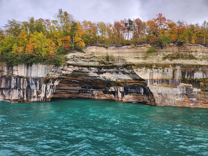
Set your paddle in the cold, clear waters of Lake Superior and let the winds and waves of Pictured Rocks push you forward along one of the Great Lakes’ most striking coastlines. Located within Burt Township, Michigan, this kayaking route traces nearly 40 miles of dramatic cliffs, caves, and waterfalls carved into the sandstone, with colors shifting through ochre, red, and cream as sunlight dances against the rocky face.
From the moment you launch at Miners Beach, the cliffs rise like ancient storytellers, daring you to explore their secrets. The journey demands attention—not just to your strokes but to the lake’s mood. Currents swirl unpredictably among caves, and sudden gusts can catch an unwary paddler off-guard. Approaching Chapel Rock, the waves hum with energy, urging a respectful distance. This isn’t a coast to conquer but to read and move with.
The tactile feel of your paddle dips rhythmically, breaking the silence between calls of distant gulls and the water’s smooth slap against rock. Inland, dense forests drape the hills above, while below, the shoreline’s dramatic cliffs offer vantage points and hidden alcoves accessible only by water. Keep an eye out for the multicolored streaks that earned this place its name—iron and mineral deposits that paint the stone with vibrant reds and yellows.
Planning for this journey means balancing your adventurous spirit with practical preparation. Kayaking here requires a sturdy, sea-worthy kayak and a willingness to navigate wind, waves, and sometimes chilly water temperatures. Depending on your endpoint, expect a full day on the water, with distances ranging up to 13 miles one-way.
Bring layered clothing, waterproof gear, and plenty of hydration. Weather can shift swiftly on Lake Superior, and while the sun lights up the cliffs, the wind may slice through the morning chill. Early summer to early fall offers calmer conditions, but always check local weather and lake forecasts before setting out.
Shoreline campsites and ranger stations offer occasional respites, but many kayakers plan day trips or arrange pick-ups at different launch points. Carry dry bags for your essentials and always wear a life jacket. Tracking water depth and watching for submerged rocks around caves and cliffs is vital—these features draw kayakers, but they demand respect.
For those ready to engage with a coastline fiercely itself, Pictured Rocks promises not just views, but a dialogue between land, water, and paddler. It’s a journey that sharpens your senses, tests your skill, and rewards with moments of pure, elemental beauty.
Nearby Trips
All Adventures
Boat Charters
Water Activities
Adventures near Munising, Michigan
Discover the unique and memorable adventures that make Munising, Michigan special.
Frequently Asked Questions
How long does the Pictured Rocks kayaking route take?
A full paddle covering the main 13-mile stretch can take between 6 to 9 hours depending on weather, paddler experience, and chosen start/end points.
Are there kayak rental options nearby?
Yes, Munising offers several rental shops supplying sea kayaks, gear, and guided tours for Pictured Rocks.
What safety precautions are needed?
Always wear a life vest, carry communication devices, keep an eye on the weather, and avoid caves during rough conditions or high waves.
Can beginners attempt this kayaking route?
The route leans toward intermediate to advanced paddlers because of the open water, wind, and navigating cliffs and caves. Beginners should consider guided tours.
Is camping allowed along the route?
Yes, but only at designated backcountry campsites managed by the National Park Service. Permits are required and should be secured in advance.
What wildlife might I encounter on this trip?
Peregrine falcons nest on the cliffs, and you may spot bald eagles, otters, and seasonal migrations of waterfowl.
Recommended Gear
Sea Kayak with Rudder
A stable, maneuverable kayak equipped with a rudder enhances control on Lake Superior’s open water and around cliffs.
Spray Skirt
Protects you from waves and splashes, keeping you dry and comfortable during the paddle.
Waterproof Dry Bags
Keep clothes, electronics, and food dry despite the inevitable splashes and wet environment.
Layered Clothing Including a Waterproof Jacket
Temperature and wind changes make layering important, with waterproof outer layers to guard against lake spray and sudden rain.
Local Insights
Hidden Gems
- "Miners Castle viewpoint offers an alternative perspective on the cliffs from above."
- "Chapel Rock’s unique patterning of iron-stained streaks visible only from the water."
- "Au Sable Point Lighthouse a few miles east shows historic guidance for Lake Superior mariners."
Wildlife
- "Peregrine falcons nesting cliffside"
- "River otters near shorelines"
- "Eagles soaring overhead especially at dawn and dusk"
History
"Pictured Rocks has been a place of significance to the Ojibwe people for generations, serving as a natural boundary and resource area. The area was later an important site for logging and mineral mining in the 19th century."