Top Scenic Backpacking Routes in Baxter State Park: Multi-Day Adventures Starting from Mount Katahdin
Baxter State Park offers some of Maine’s most compelling multi-day backpacking routes, all radiating out from the imposing Mount Katahdin. These rugged trails challenge hikers with steep climbs, rocky scrambles, and pristine wilderness while delivering unforgettable panoramic views and serene campsites. Ready your pack and boots for a balanced adventure of raw nature and practical route planning.
Permit Your Campsite Early
Baxter State Park requires advanced permits for overnight stays; secure your spot early to avoid disappointment.
Bring Durable Footwear
Trails combine rocky slabs and exposed roots, so wear sturdy hiking boots with good ankle support for safety and comfort.
Plan for Variable Weather
Mountain weather shifts quickly; pack layered clothing to adjust through sun, wind, and sudden rain.
Hydration Is Critical
Reliable water sources can be sparse on tougher sections, so carry enough water and a purification method.
Top Scenic Backpacking Routes in Baxter State Park: Multi-Day Adventures Starting from Mount Katahdin
Mount Katahdin stands as the fierce heart of Baxter State Park, daring adventurers to engage with its rugged trails and expansive wilderness. Beginning your multi-day backpacking journey here means stepping onto paths where each day challenges your endurance and rewards you with unmatched panoramas. The park’s granite peaks hold a forceful presence, while the surrounding forested valleys quietly test your grit with steep climbs and rocky scrambles.
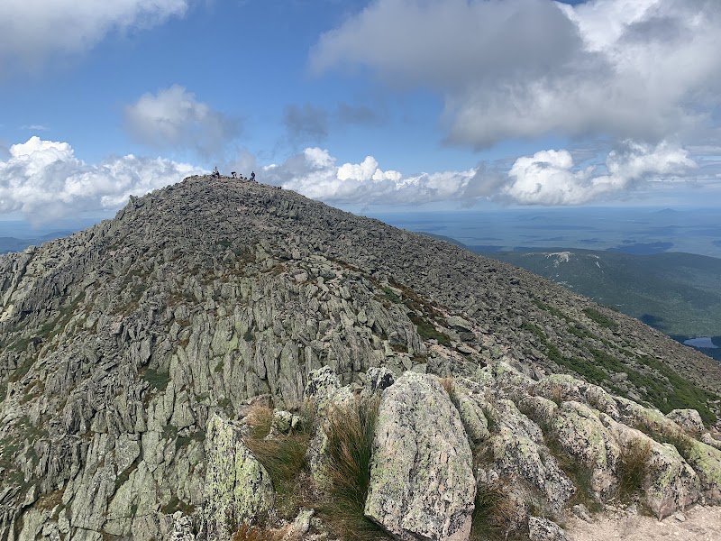
The Knife Edge Traverse is a classic start—5 miles of exposed ridges packed with steady elevation gain of nearly 2,500 feet. It demands sure footing and focus as the granite slabs push upward, offering sweeping views of Maine’s wild interior. Expect a mix of narrow pathways and straightforward rocky scrambles, punctuated by the wind’s constant whisper. This trail is best tackled clockwise, allowing the Knife Edge itself to draw your full attention while fresh.
For a longer route, the Pleasant Pond Loop creates a 12-mile circuit south of Katahdin through old-growth forest and along a crystal-clear pond that reflects the jagged skyline. The terrain here is more forgiving but still rewarding, with elevation gains around 1,000 feet and campsites by the water that invite you to pause and listen. The pond seems to breathe with the woods around it, its quiet surface disrupted only by the occasional daring fish or bird.
The Hunt Trail ascending Katahdin from the east amplifies the intensity—an 8.4-mile climb with over 4,000 feet elevation gain. Its rocky steps zigzag past waterfalls that appear to leap down the mountain’s face, challenging your pace but invigorating your senses. At higher elevations, the trees grow determinedly stunted, bracing the wind, while clouds sweep around the peak in restless, swift currents.
Planning is key: start early to avoid afternoon storms common in summer, carry hydration for long stretches without water sources, and opt for sturdy footwear because roots and slabs hold no quarter. Campsites are limited and require permits, so booking in advance is essential.
Baxter State Park’s landscapes don’t just await; they dare you to know them as they are—direct, unyielding, and raw. Whether you’re stepping lightly on the Knife Edge, resting by Pleasant Pond, or pushing toward Katahdin’s summit, this wilderness tests the body while rewarding the spirit with its unsparing beauty.
Nearby Trips
All Adventures
Boat Charters
Water Activities
Adventures near Millinocket
Discover the unique and memorable adventures that make Millinocket special.
Frequently Asked Questions
What permits are needed for backpacking in Baxter State Park?
Overnight wilderness permits are mandatory for camping in Baxter State Park. These must be reserved in advance through the park’s reservation system, especially during busy summer and fall months.
Are there reliable water sources along the Knife Edge Traverse?
Water is scarce on the Knife Edge itself; nearby streams and ponds are more accessible before and after this section. Carry sufficient water to stay hydrated during the exposed ridge portion.
When is the best time to avoid crowds on Katahdin trails?
Late spring and early fall see fewer hikers, but trail conditions are more variable. Weekdays during these periods offer the most solitude compared to summer weekends.
What wildlife might I encounter on multi-day hikes here?
Expect to see white-tailed deer, moose in distant wetlands, and birds such as the hermit thrush and peregrine falcon. Be aware of black bears; proper food storage is required.
Are there any lesser-known viewpoints off the main trails?
Yes, the chairback trail junction near Katahdin provides a quieter vantage overlooking the Penobscot River valley, perfect for sunrise photography without the crowds.
What historic or cultural significance does Baxter State Park hold?
The park honors Percival Baxter, who protected this land from development. The region also has historical ties to Native American tribes who considered Katahdin sacred.
Recommended Gear
Hiking Boots
Sturdy boots provide ankle support and grip on rocky and root-filled trails.
Layered Clothing System
Allows quick adjustments for changing weather from cool mornings to warm afternoons and sudden showers.
Water Filter or Purification Tablets
Clean hydration is crucial on longer trails where water stops are unpredictable.
Lightweight Tent or Shelter
Required for overnight camping in designated areas and protection from the elements.
Local Insights
Hidden Gems
- "Chairback Mountain overlook—less crowded and offers sweeping valley views."
- "Shawnee Peak—an isolated summit south of Katahdin with quiet ponds nearby."
- "The Hermit Stream Falls—smaller but stunning cascading waters hidden on longer loops."
Wildlife
- "Black bears often roam the forests but are mostly shy."
- "Moose inhabit lower wetlands and forest edges."
- "Peregrine falcons nest along steep cliffs—watch for aerial displays."
History
"Percival Baxter purchased this land to protect it from logging, donating it to Maine as a state park; the area remains one of the last large, undeveloped wilderness areas in the Northeast."