Best Day Hikes Around Millinocket: Exploring the Hidden Trails Beyond Baxter State Park
Beyond Baxter State Park, the trails around Millinocket offer hikers a range of challenges and scenic rewards. From rugged ridges to peaceful streams, discover lesser-known paths that invite exploration and preparation for a day immersed in Maine’s wild forests.
Wear Sturdy Hiking Boots
Trails feature mixed terrain including rocky ridges and soft forest floors, so boots with good ankle support and traction are essential.
Start Early to Avoid Afternoon Storms
Summer storms are frequent in the region; begin hikes by mid-morning to complete routes safely before afternoon weather changes.
Carry At Least 2 Liters of Water
Though streams line parts of the trails, water availability varies; staying hydrated ensures energy on longer climbs.
Check Trail Conditions Before You Go
Weather and seasonal changes affect trail accessibility; consult local resources or ranger stations for up-to-date info.
Best Day Hikes Around Millinocket: Exploring the Hidden Trails Beyond Baxter State Park
Millinocket offers more than just a gateway to Baxter State Park. Its surrounding wilderness invites hikers of all levels to engage with nature on trails that challenge and charm in equal measure. Beyond the popular peaks and established routes, these lesser-known paths reveal deep forests that breathe with life and ridges that open to views daring you to keep climbing.
Start with the West Branch Trail, a 5.4-mile loop pushing through pine and hardwood corridors, where the West Branch Penobscot River dares you to follow its course. This moderate hike features a steady 900-foot elevation gain over mixed terrain—well-trodden yet cloaked in quiet solitude. The path dips close to moss-covered boulders and winds through occasional clearings where sunlight earns its place between the trees.
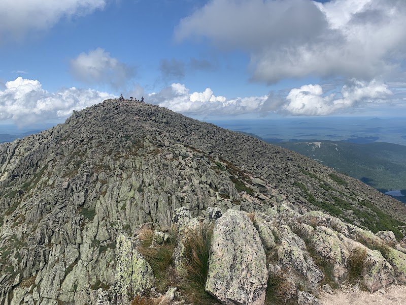
A more rigorous option is the Owl Ridge Trail, 7 miles one-way with an elevation gain of 1,600 feet. The ridge asserts itself sharply, its craggy slopes fiercely alive underfoot. Expect rugged rock scrambles balanced by stretches of soft needle-covered ground. The trail culminates in vistas that cast Millinocket’s forested expanse like a living map, rivers and mountains pulling your gaze farther.
For a shorter diversion, the Sandy Stream Trail provides a manageable 3.8 miles with gentle elevation, ideal for casual explorers or families. The trail embraces the sandy banks of a burbling stream, which pushes forward with a lively voice, guiding hikers through a forest that shifts from dense evergreens to light-filled birches.
Preparation is key. Familiar footwear with reliable traction is essential, especially on uneven or rocky sections. Carry 2 liters of water—streams here feed the forest, but some sections run dry. Early starts help avoid afternoon thunderstorms common in summer, and layered clothing prepares you for sudden temperature changes at higher elevations.
Each trail is an invitation to engage with a landscape fiercely itself: rivers that push, ridges that challenge, and forests that watch quietly. Bring curiosity and respect for this rugged ground. The reward is a day steeped in adventure, clarity, and the steady rhythm of your own footsteps meeting the wild.
Nearby Trips
All Adventures
Boat Charters
Water Activities
Adventures near Millinocket
Discover the unique and memorable adventures that make Millinocket special.
Frequently Asked Questions
Are the trails pet-friendly around Millinocket?
Many trails allow dogs, but it’s important to keep them leashed due to wildlife and other hikers. Always carry water for your pet and watch for ticks, especially in warmer months.
What wildlife might I encounter on these hikes?
White-tailed deer, moose, and black bears roam the forests here. Early mornings and dusk are best for sightings. Be sure to make noise on trails to alert animals and avoid surprise encounters.
Is cell phone reception reliable on these trails?
Reception can be spotty to nonexistent, especially deeper into the woods or on ridges. It’s wise to carry a map and compass and let someone know your itinerary.
Can I swim or ford streams along these routes?
Streams are often shallow and suitable for dipping or cooling off, but water levels can rise quickly after rain. Use caution for any crossings, especially if currents become swift.
Are there any permits required for these hikes?
No permits are required for the day hikes around Millinocket outside Baxter State Park, but some areas might have parking fees or seasonal access restrictions—check local ranger info.
Where can I find reliable trail condition updates?
The Millinocket Chamber of Commerce and Baxter State Park rangers provide current trail information. Local outdoor stores also offer insights from recent hikers.
Recommended Gear
Hiking Boots
Provides ankle support and grip on mixed surfaces, essential for safely managing rocky and uneven terrain.
Water Bottle or Hydration Pack
Maintains hydration, especially necessary during warmer months or longer hikes where water sources may be sparse.
Layered Clothing
Adjusts to changing temperatures and weather, from cool mornings to sudden rain or wind at higher elevations.
Trekking Poles
Aid stability on steep ascents or loose surfaces, reducing strain on knees during long hikes.
Local Insights
Hidden Gems
- "A small viewpoint on Owl Ridge Trail offers unexpected panoramic views of local rivers winding through the forest, less crowded than summit points."
- "An old stone foundation near Sandy Stream Trail hints at early settler campsites—quiet spots for rest and reflection."
Wildlife
- "Look for the elusive black-throated green warbler in spring, its unfamiliar call weaving amid pine needles."
- "American marten occasionally cross forest trails, a rare sight for hikers patient enough at dawn."
History
"Millinocket’s heritage as a logging town is reflected in subtle ways—fallen, mossy logs and weathered ax marks sometimes surface along trails, reminders of human interaction with this fierce landscape."