Summit to Sea: Hiking Mount Katahdin and Exploring the Gulf of Maine
Mount Katahdin challenges with raw rock and steep ridges, rewarding hikers with sweeping views of the Gulf of Maine. This adventure combines demanding mountain terrain with the rugged serenity of Maine’s coast, perfect for outdoor enthusiasts ready to engage fully with nature’s complexities.
Secure Your Baxter State Park Permit Early
Permits are required year-round to hike Mount Katahdin and must be reserved months in advance during peak season to ensure access.
Wear Footwear with Excellent Traction
Trail sections include granite slabs and steep rocky terrain where slip-resistant, sturdy boots can prevent injury.
Start Hike Early to Avoid Afternoon Thunderstorms
Weather changes rapidly; beginning before dawn maximizes daylight and safety on exposed ridges like the Knife Edge.
Bring Ample Water and Layers
The mountain’s microclimate shifts quickly—stay hydrated and dress in moisture-wicking clothes with insulating layers.
Summit to Sea: Hiking Mount Katahdin and Exploring the Gulf of Maine
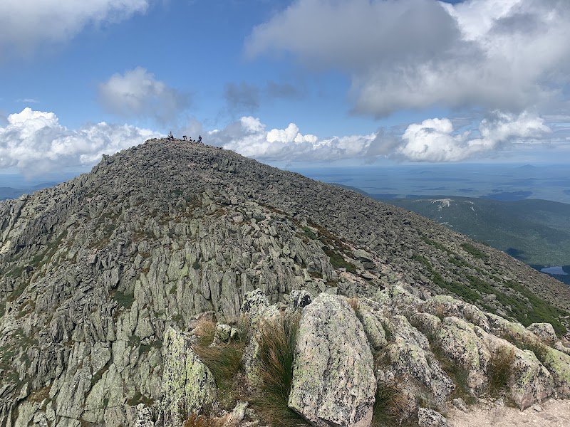
Mount Katahdin rises with a raw insistence, its granite face daring you to move upward where the forest thins and the wind speaks sharply. The Appalachian Trail’s northern terminus, this peak is not a casual stroll but an agreement with a mountain fiercely itself—steep, rugged, and unyielding. Starting at the wooded Chimney Pond, the trail winds through dense fir trees, their shadows cool yet watchful. The air hums with pine and damp earth, every footstep a dialogue with the natural world. Ascending 4,000 feet over approximately 10 miles round trip, hikers navigate slick rock ledges, granite slabs, and exposed roots. The Knife Edge, a narrow, jagged ridge, is the apex of challenge, where the mountain demands steady footing and respect.
From atop Katahdin, the view unfolds vast and immediate. The Gulf of Maine sprawls eastward, its waters shimmering beyond the tapestry of coastal islands and inlets. Here, the sea is alive, currents pushing forward and tides shifting with an urgency that echoes the mountain’s own pulse. Descending to the coastline, the landscape softens but remains compelling. Rugged cliffs brush sharply against the salty air, and hidden coves invite exploration. The Maine coast’s complexity testifies to the land-sea relationship, a dynamic dance of stone, water, and wind.
Planning requires pragmatism: good waterproof boots with solid grip, layered clothing for swiftly changing weather, and ample water—both for hydration and to cool the skin during strenuous climbs. Aim for early starts to avoid afternoon storms and enjoy quieter trails. Permits are essential, and reservations fill quickly; securing your place months ahead is wise. Be prepared to carry out all waste and respect natural quietude.
Beyond the physical challenge, the adventure sharpens the senses. The mountain and sea are not just backgrounds; they engage the explorer actively, responding to footsteps and breaths with rustling leaves, rushing streams, and the resilient cry of seabirds. This journey from summit to sea connects elements in a way that is both invigorating and humbling, a vivid reminder that wild places remain untamed and insist on mutual respect.
Nearby Trips
All Adventures
Boat Charters
Water Activities
Adventures near Millinocket, Maine
Discover the unique and memorable adventures that make Millinocket, Maine special.
Frequently Asked Questions
How difficult is the Knife Edge on Mount Katahdin?
The Knife Edge is a narrow, exposed ridge requiring sure footing and no fear of heights. While not technical climbing, it demands careful balance and attention, especially in wet or windy conditions.
Are reservations required to hike Mount Katahdin?
Yes. Baxter State Park requires permits and overnight reservations for Katahdin access, particularly from late May through October. Permits must be secured months in advance due to limited capacity.
What is the total distance and elevation gain for the hike?
The most common route via the Hunt Trail is approximately 10 miles round trip with roughly 4,000 feet of elevation gain from base to summit.
Can beginners attempt the Katahdin summit?
Due to the hike's length, steepness, and technical sections, it is best suited for fit and experienced hikers. Beginners should gain experience on less demanding trails before attempting Katahdin.
What wildlife might I encounter on the trails and coast?
Expect to see white-tailed deer, peregrine falcons near cliff faces, and harbor seals or porpoises along the Gulf’s coastline. Black bears inhabit the park but are generally shy.
Is it possible to extend the adventure beyond the summit?
Yes. Several multi-day backpacking options start from Katahdin, and coastal exploration along the Gulf of Maine offers kayaking, tidepooling, and scenic drives for a varied outdoor experience.
Recommended Gear
Sturdy Hiking Boots
Provides grip and ankle support on rocky, uneven terrain.
Layered Clothing System
Allows temperature regulation in unpredictable mountain weather.
Hydration System (at least 3 liters)
Maintains hydration through long, strenuous ascents.
Headlamp with Spare Batteries
Essential for early starts and unexpected delays to ensure safe descent in darkness.
Local Insights
Hidden Gems
- "Table Land - a flat, sub-alpine plateau just below the summit with panoramic views and fewer crowds"
- "Saddle Trail - quieter descent route offering forest immersion and streams"
- "Baxter Peak’s quieter north face viewpoints"
- "Remote tide pools along Schoodic Point on the Gulf coast"
Wildlife
- "Peregrine Falcons nesting on cliff ledges"
- "Harbor seals hauled out near rocky shores"
- "Eastern red-backed salamanders beneath leaf litter"
- "Black bear tracks common in early morning"
History
"Mount Katahdin has long been sacred to the Penobscot Nation and represents the spiritual heart of Maine. Baxter State Park was established through Governor Percival Baxter’s land donations to preserve the mountain as wilderness for future generations."