Exploring The Best Scenic Backpacking Routes In The 100-Mile Wilderness Near Baxter State Park
Discover the raw beauty of the 100-Mile Wilderness near Baxter State Park, where rugged trails wind through old forests, lakes, and roaring streams. This guide highlights top backpacking routes that combine scenic rewards with practical advice for a safe and memorable adventure.
Hydrate with Caution
Though water sources like streams and lakes are frequent, always carry a reliable water filter or purification method to avoid waterborne illnesses.
Footwear Matters
Wear sturdy, well-broken-in hiking boots with decent ankle support to handle rocky and uneven terrain throughout the trails.
Early Season Start
Start hikes early in the day to avoid afternoon thunderstorms common in summer and to maximize daylight hours for safe progress.
Prepare for Bug Season
Late spring and early summer bring black flies and mosquitoes—pack insect repellent and consider wearing long sleeves and pants.
Exploring The Best Scenic Backpacking Routes In The 100-Mile Wilderness Near Baxter State Park
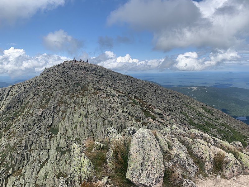
The 100-Mile Wilderness, extending south from Baxter State Park in Maine, presents one of the most rugged and compelling stretches of forest in the northeastern United States. It challenges hikers with its raw, fiercely independent landscape — where old-growth pines and birch trees crowd narrow paths, and rivers push forward with relentless energy. This region isn’t about easy strolls; it’s about engaging with nature on its own terms, where every climb and descent reveals raw, unfolding scenery.
Here are some of the best backpacking routes that capture the spirit and scenic variety of this wilderness:
1. Nahmakanta Stream to Big Eddy Trail Loop (23 miles) Starting at Nahmakanta Public Reserved Land, this route moves alongside the ever-daring Nahmakanta Stream, crossing roots and rocks as it climbs gentle ridges. The trail dips into deep forests where the air smells of moss and pine needles damp from frequent rain. The final stretches offer views of clear, shimmering water pools where brook trout dart beneath the surface. Expect moderate elevation gain around 2,000 feet with uneven terrain requiring good traction.
2. Jo-Mary Lake Circuit (18 miles) This path skirts around Jo-Mary Lake, a mirror reflecting cloud-streaked skies. Wide campsites allow for restful stops close to water, where loons call at dawn. The terrain is mixed — from smooth, flat lake shores to rocky inclines punctuated by blueberry bushes and fir trees lending scent and shade. Elevation rises steadily but never sharply, making it an ideal choice for those seeking a balanced challenge.
3. Old Logging Roads to Little Wilson Falls (15 miles) An approachable yet stirring route weaving old logging roads and deciduous woods that extend autumn’s golden glow. Waterfalls splash fiercely here, boasting crashing currents that seem to dare every traveler to sit and watch their power. Elevation gain is manageable at roughly 1,000 feet, perfect for those new to the wilderness but ready to engage physically.
Practical Tips for Success: Hydrate thoroughly—streams and lakes are plentiful but treat water before drinking. Sturdy, well-broken-in boots with ankle support will help on rugged sections. Early summer or fall visits mean cooler temps and fewer bugs. Bring a reliable map and compass; cell service is sparse.
The 100-Mile Wilderness tests resolve and rewards with honestly earned solitude and natural beauty. Whether it’s the rocky outcrops offering vast woodland vistas or the whispering fir forests that seem to lean in and listen, these trails draw you into an environment fiercely itself—waiting for respectful interaction, not conquest.
Nearby Trips
All Adventures
Boat Charters
Water Activities
Adventures near Millinocket
Discover the unique and memorable adventures that make Millinocket special.
Frequently Asked Questions
Are there reliable water sources throughout the 100-Mile Wilderness?
Yes, the region is rich with streams, brooks, and lakes. However, it’s essential to purify any water before drinking due to natural contaminants.
Is camping allowed anywhere in the 100-Mile Wilderness?
Camping is permitted, but only in designated areas or at least 150 feet away from water sources and trails. Respect local regulations to preserve the environment.
What wildlife might I encounter while hiking here?
Expect to see moose, white-tailed deer, black bears, and a variety of bird species, including loons and the occasional ruffed grouse. Always store food securely.
How well-marked are the trails in this remote wilderness?
Trails can be rough and markings sparse or faded. Navigation skills and a reliable map and compass are necessary for safe travel.
When is the best time to see fall foliage in this area?
Late September to mid-October offers peak foliage with vibrant reds, oranges, and yellows across the hardwood forests.
Are there any historical sites along the trails?
Remains of old logging camps and stone foundations peek through woods, telling quiet stories of Maine’s logging past but are typically unmarked.
Recommended Gear
Lightweight Backpacking Tent
Provides necessary shelter from insects and weather while keeping weight low on long trail days.
Water Filter or Purification System
Ensures safe drinking water from natural sources along the trail.
Hiking Boots with Ankle Support
Protects feet and ankles on rocky, uneven terrain common in this wilderness.
Insect Repellent
Keeps biting insects at bay during peak black fly and mosquito season.
Local Insights
Hidden Gems
- "Smith Brook Falls, a lesser-known waterfall with quiet pools perfect for a break."
- "The viewpoint atop Little Wilson Pond Spur Trail, offering a sweeping panorama with minimal crowd."
Wildlife
- "Keep watch for moose near wetland areas at dawn and dusk."
- "Look for indicators of beaver activity along streams and ponds."
History
"This wilderness was heavily logged in the late 19th and early 20th centuries; remnants of those operations remain in the form of old logging roads and abandoned campsites."