The Traprock Ridge Challenge: Hiking the Metacomet Trail
The Metacomet Trail offers a rugged, action-packed hike along Connecticut’s Traprock Ridge, featuring sharp cliffs and sweeping valley views. Perfect for those ready to meet the challenge head-on, this trail blends natural beauty with a demanding terrain that rewards preparedness and grit.
Hydrate Early and Often
The ridge’s dry terrain and limited water sources mean you should carry ample water—at least 2 liters—to stay fully hydrated throughout the hike.
Wear Sturdy, Grippy Footwear
Expect rocky, uneven ground with frequent elevation changes; trail runners or hiking boots with solid traction are vital to avoid slips on steep ledges.
Start Early for Cooler Conditions
Mornings bring cooler temperatures and softer light, making for safer hiking conditions and better visibility across ridges and vistas.
Use Trail Markings and Maps
While the blue diamond markers guide the way, pack a detailed map or GPS device since some areas overlap with neighboring trails and road crossings.
The Traprock Ridge Challenge: Hiking the Metacomet Trail
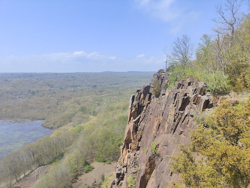
Stretching over 50 miles along Connecticut’s rugged Traprock Ridge, the Metacomet Trail offers a hiking experience that balances raw nature with a sturdy challenge. This trail carves through dense forests, ascends sharp cliff faces, and unveils panoramic views that stare out over the Connecticut River Valley. It’s a route where nature dares your resolve and tests your pace. The trail’s terrain is a mix of rocky ledges, narrow ridgelines, and forest carpeted paths, with elevation gains pushing about 1,500 feet on steeper stretches.
The hike invites you into a rhythmic push and pause—steps crunch on weathered stones, branches brush with wind, and the sky opens to reveal sweeping views behind a playground of rugged traprock outcrops. Each ascent demands attention; the cliffs here don’t yield easily, their edges sharp and their presence fierce. The trail challenges your footing and will, requiring sturdy boots with good grip; slip carelessly and the rawness of the ridge quickly reminds you it’s unforgiving.
Practical planning is key. Start early to beat the midday heat, especially in summer months when the ridge basks in full sun. Carry at least two liters of water; the porous traprock pulls moisture from soil, leaving spring-fed streams sparse. Wear layered clothing—the wind atop the ridge cuts through, even on warm days. Navigation is straightforward with blue diamonds marking the route, though some sections weave closely with other trails. A topo map or GPS is a smart backup.
Look for quiet moments when the forest muffles your footsteps and the air hums with bird calls. The ridge feels alive, not passive—a force that presses in around you, pushing and pulling with weather and light. Whether you’re tackling the full trail in stages or hitting iconic viewpoints like Mount Tom or East Rock, the challenge is the same: respect what the ridge demands and stay alert.
The Traprock Ridge isn’t a stroll in the park. It’s a conversation with stone and sky, a test of endurance with a clear-cut prize: nature fiercely itself, waiting to be met head-on.
Nearby Trips
All Adventures
Boat Charters
Water Activities
Adventures near Meriden, Connecticut
Discover the unique and memorable adventures that make Meriden, Connecticut special.
Frequently Asked Questions
How long is the Metacomet Trail along Traprock Ridge?
The Metacomet Trail spans roughly 51 miles along Traprock Ridge, typically tackled in sections over multiple days but suitable for challenging day hikes.
Are there water sources along the trail?
Water is scarce on the ridge due to porous traprock draining moisture quickly. Hikers should carry all necessary water, especially in summer.
What level of experience is needed for this hike?
The trail is best suited for hikers with moderate to advanced experience because of steep climbs, rocky terrain, and variable conditions requiring good navigation skills.
Is the trail well-marked?
Yes, the Metacomet Trail is marked with blue diamond blazes, though overlaps with other trails mean a map or GPS device is advisable for clarity.
When is the best time to hike the trail?
Spring and fall offer the best balance of comfortable weather and scenic views, though early mornings in summer can also be pleasant with proper hydration.
Are dogs allowed on the trail?
Dogs are permitted but must be kept on a leash due to the rugged terrain and potential encounters with wildlife.
Recommended Gear
Hiking Boots with Good Traction
The mix of rocky ledges and uneven surfaces demands dependable footwear to prevent slips and provide ankle support.
Hydration System (Water Bottles or Bladder)
With few reliable water sources on the ridge, carrying sufficient water is critical, especially during warmer months.
Layered Clothing
Variable temperatures across the ridge call for easy-to-adjust layers to maintain comfort from cool mornings to warmer afternoons.
Trekking Poles
Poles help maintain balance on slippery or icy trail sections and reduce impact on knees during steep descents.
Local Insights
Hidden Gems
- "The lesser-known cliff overlook near Ragged Mountain offers solitude and panoramic eastward views."
- "The historic Powder Ridge Ski Area remnants provide a unique spot for quiet reflection along the trail."
Wildlife
- "Keep an eye out for timber rattlesnakes basking on warm rocks and migratory hawks soaring the ridge thermals."
- "Eastern box turtles occasionally cross forest paths, signaling a healthy ecosystem."
History
"The trail runs along ridges that once provided strategic vantage points during colonial times and includes areas with Native American significance tied to the Quinnipiac tribe."