Navigating Nature: The Rossendale Walking Festival Experience in Rawtenstall
Rossendale Walking Festival in Rawtenstall brings accessible yet challenging trails to hikers of all experience levels. Explore forested paths and open moorlands while gaining practical tips for preparation to enjoy this dynamic Lancashire landscape.
Choose Footwear for Variable Terrain
Trails range from muddy woodland floors to stony upland paths; waterproof boots with solid tread ensure stability and comfort throughout your hike.
Carry Adequate Hydration
Bring at least one litre of water; many routes have no safe water sources en route, and the physical effort on moorland can increase dehydration risk.
Start Early for Best Conditions
Morning hikes offer quieter trails, cooler temperatures, and reduced risk of afternoon rain showers typical in this region.
Use Navigation Aids
Though routes are marked, carrying a local map or GPS app prevents disorientation, especially on longer or less trafficked paths.
Navigating Nature: The Rossendale Walking Festival Experience in Rawtenstall
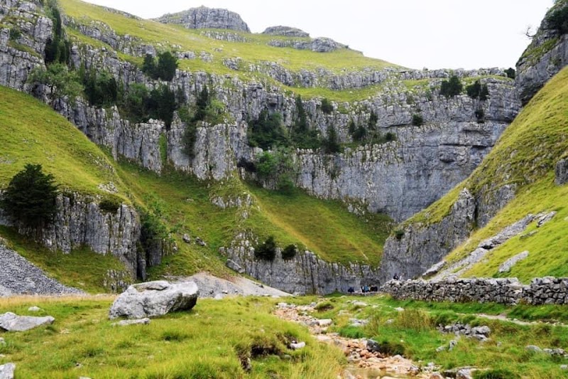
The Rossendale Walking Festival unfolds across the hills and woods around Rawtenstall, Lancashire, offering routes that welcome everyone from casual walkers to seasoned hikers. With trails ranging from gentle 3-mile strolls to more demanding 12-mile treks climbing over 900 feet, the festival introduces an invigorating variety of landscapes—soft forest floors carpeted with leaves, open moorland where the wind dares you forward, and sweeping views that hold the grit and grace of northern England’s character.
Begin your day in Rawtenstall, where the town’s historic charm meets landscapes fiercely themselves. Trails weave through woodland sections where trees lean in like old friends, guiding you along narrow, sometimes uneven paths that reward careful steps with bursts of sunlight and the earthy scent of moss and wet stone. Beyond the forests, the moorland opens, raw and restless under wide skies, pushing walkers to engage with the elements—sometimes teasing you with quick changes in weather or headwinds that test your stamina and resolve.
Practical preparation will enhance the experience. Footwear with reliable grip is critical; many paths are stony or muddy depending on recent weather. Carry at least a litre of water and layer clothing to manage shifting temperatures from shaded woodlands to exposed hilltops. Timing your hike allows for optimal conditions—early morning starts catch the dew and quieter trails, while afternoon walks benefit from warmer temperatures but can bring more changeable weather.
The festival’s marking system is clear, but local maps or a GPS app loaded with the Rossendale routes are recommended to keep on track, especially on the longer or less frequented routes. Along the way, local fauna—the occasional darting squirrel or cautious grouse—add life to the terrain, alongside subtle cultural marks like old stone walls and remnants of industrial heritage tucked into the hills.
By the end of a route, you’ll have wrestled with this landscape on its terms—feeling the push of natural forces, the forest’s quiet insistence, and the open stretches that challenge your lungs and pace. It’s an adventure firmly planted in the here and now, where preparation meets unpredictability. Whether aiming for the full festival experience or a single day’s hike, Rawtenstall’s walking festival offers a grounded, engaging day outdoors defined by honest terrain and spectacular views.
Nearby Trips
All Adventures
Boat Charters
Water Activities
Adventures near Rawtenstall, Lancashire
Discover the unique and memorable adventures that make Rawtenstall, Lancashire special.
Frequently Asked Questions
Are the Rossendale Walking Festival routes suitable for families?
Yes, the festival offers a mix of route lengths and difficulties, including shorter, more gentle paths suitable for families and casual walkers. Check individual route details in advance to match your group’s abilities.
What wildlife might I encounter during the festival?
Expect to see local species such as red squirrels in wooded areas, various birds like grouse and kestrels, and seasonal insects and butterflies. Early mornings and quieter trails improve your chances of glimpses.
Is public transportation available to Rawtenstall for the festival?
Rawtenstall is accessible by train and bus services from Manchester and surrounding towns, making it a practical base without a car. Check schedules ahead, especially on weekends, to align with your hike timing.
What should I know about the terrain when planning my hike?
Terrain varies from soft earth and leaf-covered forest paths to open, rocky moorland with elevation gains up to 900 feet. Hikers should be prepared for potentially slippery surfaces after rain.
Are dogs allowed on the festival trails?
Dogs are welcome on most routes but should be kept on leads, especially in areas with grazing livestock and wildlife. Always check individual trail rules and respect local guidelines.
What local cultural features might I discover along the paths?
Stone walls, old quarry workings, and small chapels link the landscape to Rawtenstall’s industrial past. These traces offer a tangible connection to the community’s heritage alongside natural beauty.
Recommended Gear
Waterproof Hiking Boots
Provide necessary grip and protect feet from wet, uneven terrain common throughout the festival trails.
Water Bottle (1L+)
Staying hydrated is essential, particularly given the physical demands and limited water points on the routes.
Layered Clothing
Adjust to temperature swings from cool mornings to warmer afternoons across changing microclimates.
Compact Map or GPS Device
Ensures accurate navigation—important as some paths intersect and markers may be obscured.
Local Insights
Hidden Gems
- "Ringley Old Bridge viewpoint, offering serene river views away from main trails"
- "The quiet summit of Holdworth Hill, a lesser-known vantage point with panoramic moorland views"
Wildlife
- "Native red squirrels thriving in the forested pockets"
- "Seasonal appearances of curlews and lapwings on moorland"
History
"Rawtenstall’s walking paths often trace routes linked to its 19th-century textile industry, providing a living landscape where industry met nature. Stone walls and former quarry sites highlight this intersection."