Best Secluded Hiking Trails Around Stratton Mountain: Forests, Ridges & Scenic Vistas
Stratton Mountain offers more than well-worn paths. Discover secluded hikes where rugged ridges and deep forests provide quiet adventure punctuated by sweeping views. This guide equips you with practical details and essentials to explore trails that challenge and inspire in equal measure.
Hydrate Before and During Hikes
Water sources are limited on many of these trails. Carry at least 2 liters per person and consider a water filter if planning longer hikes.
Use Layered Clothing
Temperature changes are common between shaded valleys and exposed ridges. Pack breathable layers that can be added or removed easily.
Start Early in the Day
Begin hikes in the morning to avoid afternoon heat and afternoon weather shifts. This timing also allows for a comfortable pace with plenty of daylight.
Carry Navigation Tools
Some trails, like the Goshen Trail, can be faintly marked. A map, compass, or GPS unit ensures you stay on track.
Best Secluded Hiking Trails Around Stratton Mountain: Forests, Ridges & Scenic Vistas
Stratton Mountain, located in southern Vermont, offers more than just its popular ski slopes and crowded summer routes. For those seeking quiet hiking experiences away from the weekend crowds, several trails carve through dense forests, crest rugged ridges, and open to sweeping views that reward persistence. Each hike demands respect—these paths reflect a land fiercely itself, with nature pushing back in thorny scrambles and ridge winds that test your focus.
Start your adventure on the Sherburne Pass Loop, a 5.6-mile circuit with approximately 1,000 feet of elevation gain. The trail moves steadily through spruce and hardwood forests where sunlight sparsely tricks the floor, while the mountain ridges invite gusts that dare you to steady your step. The terrain mixes firm dirt with scattered rocks; waterproof boots with solid tread are a must. Timing is key: mornings cut through the humid haze before mid-day heat settles.
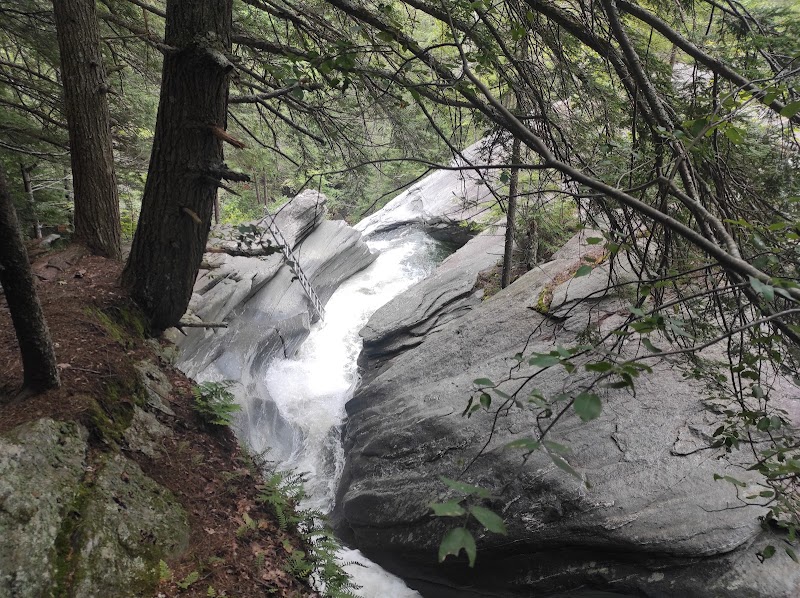
For those ready to tackle a more demanding route, the Stratton Mountain Trail itself climbs 3.5 miles one way with a 1,900-foot elevation rise. It traces exposed ridges where wind has shaped the trees into leaning guardians, branches clawing at the blue. The summit reveals panoramic views spanning the Green Mountains and beyond. Prepare for switchbacks and occasional slick rock faces, particularly after rain. Hydration cannot be overlooked here; with limited natural water sources along the trail, carry enough for the round trip.
If solitude is your goal, try the Goshen Trail, an 8.2-mile path weaving through quiet woods far south of the main mountain. This trail demands endurance more than technical skill but rewards hikers with serene streams that seem to flow with purpose, birdcalls sharp, and occasional glimpses of hidden mossy clearings. Trail markers are subtle, so a map or GPS device will keep you on course.
Regardless of which trail you choose, timing visits during the shoulder seasons—late spring and early fall—helps avoid crowds and enjoy cooler temperatures. Wear layers to adjust to fluctuating ridge winds and shaded valleys. Carry trail essentials: a reliable water source, trail snacks, a map, and weather protection. Always inform someone of your plans when heading into these less trafficked areas.
Taking on these secluded trails around Stratton Mountain is not just a walk in the woods. It’s a physical conversation with the mountain’s ridge lines and forests, a measured challenge that blends the thrill of discovery with real-world trail knowledge. Pack smart, move steady, and let the mountain speak through its steep climbs, whispering streams, and wide-open skies.
Nearby Trips
All Adventures
Boat Charters
Water Activities
Adventures near Manchester
Discover the unique and memorable adventures that make Manchester special.
Frequently Asked Questions
Are the Stratton Mountain trails dog-friendly?
Yes, most trails allow dogs but must be kept on a leash. Be mindful of wildlife, and ensure your dog is comfortable with variable terrain.
Where can I find water sources along these hikes?
Streams exist mainly on the Goshen Trail but may be seasonal and unreliable. It’s best to start fully hydrated and carry extra water.
Is there cell phone coverage on these trails?
Coverage is spotty on ridges and in valleys. Do not rely solely on cell phones for navigation or emergencies.
Which trail offers the best panoramic views?
The Stratton Mountain Trail reaches several summits with broad views of the Green Mountains and surrounding valleys, especially rewarding at sunrise or sunset.
Are there any cultural or historical landmarks along the trails?
Some areas near Sherburne Pass hold remnants of early logging and stone foundations, offering glimpses into local settler history.
What wildlife might I encounter?
Expect to see white-tailed deer, red foxes, and if lucky, a glimpse of black bears or moose in remote sections, particularly during dawn and dusk.
Recommended Gear
Hiking Boots
Sturdy boots with good ankle support and grip handle rocky and sometimes muddy terrain comfortably.
Hydration System
A hydration bladder or water bottles that allow easy access to water on-the-go.
Layered Clothing
Moisture-wicking base layers, insulating mid-layers, and a windproof shell prepare you for temperature swings.
GPS or Map and Compass
Navigation tools are essential on less-marked trails like the Goshen Trail to avoid getting off-route.
Local Insights
Hidden Gems
- "The small ledge viewpoint halfway up the Sherburne Pass Loop offers a quiet spot rarely visited but with excellent eastward outlook."
- "Mossy clearings along Goshen Trail provide a quiet pause with subtle natural beauty."
Wildlife
- "white-tailed deer"
- "black bear (rare sightings)"
- "red fox"
- "various songbirds"
History
"This region was heavily logged in the 1800s, leaving behind old stone cellar holes along Sherburne Pass trails, reminders of past homesteads."