Hiking the Yorkshire Dales from Leyburn: Panoramas and Village Charm
Experience the rugged beauty of the Yorkshire Dales on a hike from Leyburn that balances panoramic views with the charm of traditional villages. This accessible route offers a mix of limestone paths and forested stretches, ideal for adventurers seeking both natural splendor and local culture.
Wear sturdy boots
The terrain varies from rocky limestone pavement to uneven paths, so solid footwear with good grip is essential to avoid slips.
Bring sufficient water
While quaint villages offer chances for refreshments, carry enough water to stay hydrated throughout your hike, especially in warmer months.
Start early
Begin your walk in the morning to enjoy cooler temperatures and take advantage of soft natural lighting for panoramic views and photography.
Mind the weather
Weather in the Dales can shift quickly—pack waterproof layers and check forecasts before setting out to stay comfortable and safe.
Hiking the Yorkshire Dales from Leyburn: Panoramas and Village Charm
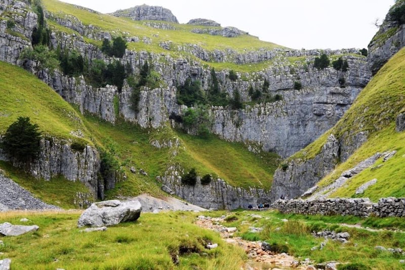
Stretching across the rolling hills and limestone cliffs of North Yorkshire, the Yorkshire Dales command attention with their fierce, ever-changing character. From Leyburn, a vibrant market town that balances quaint village life with easy access to outdoor adventure, you can step into a hike teeming with panoramic views and the touchstones of rural England.
Start your journey just outside Leyburn, where the trail guides you over uneven limestone pavements and along dry stone walls that push forward like quiet guardians of the landscape. Expect an elevation gain around 300 meters over a 10-kilometer loop, manageable but lively enough to keep the heart engaged.
The path whispers through forested patches where birds engage in purposeful chatter and winds dare the bracken to bend. Each bend gifts a new frame: distant hills rolling stubbornly against the sky, the River Ure weaving below like a silver thread that won’t be tamed. Quaint villages—spotted along the route—offer moments to pause, soak in centuries-old stone cottages, or enjoy the subtle warmth of local tea rooms.
Preparation is straightforward but necessary: sturdy footwear to handle loose gravel and variable terrain, layered clothing to respond to shifting weather, and a water supply to meet the demands of this living landscape. Early morning departures or late afternoons provide the softest light, the perfect window for clear vistas and cooler air.
This is hiking with a practical spirit: respect for nature’s rhythms, a readiness to move steadily and thoughtfully, and the reward of vistas that command attention without shouting. Here, adventure isn’t about conquering but moving with a force that is fiercely itself—a countryside that invites both reflection and action.
Whether you’re chasing views, village charm, or the blend of both, Leyburn and the Yorkshire Dales illuminate each step as much as your destination.
Nearby Trips
All Adventures
Boat Charters
Water Activities
Adventures near Leyburn
Discover the unique and memorable adventures that make Leyburn special.
Frequently Asked Questions
How challenging is the hike around Leyburn in the Yorkshire Dales?
The hike is moderate in difficulty with around 10 kilometers distance and 300 meters elevation gain. The terrain includes limestone pavements and forest trails that can be uneven, so a reasonable level of fitness and stable footwear are recommended.
Are there opportunities to stop for food or rest in the villages along the route?
Yes. Leyburn itself has several pubs and tea rooms ideal for breaks before or after your hike. Smaller villages on the trail may also offer quaint local cafes, but their opening hours can vary seasonally.
What’s the best time of day to start the hike for optimal views?
Starting early in the morning gives you cooler conditions and soft, directional lighting that enhances the rolling landscapes and village scenes, making it ideal for both hiking comfort and photography.
Is the trail suitable for families or beginner hikers?
Families can enjoy parts of the route, especially those comfortable with moderate walking and some uneven surfaces. Beginners should prepare for variable terrain and possibly adjust the route according to energy and experience levels.
Are there any local environmental rules or guidelines hikers should follow?
Yes. It’s important to stick to marked paths to protect fragile limestone grasslands, respect livestock by closing gates, and carry out all litter to maintain the area’s natural beauty and ecology.
Can I navigate the trail with a smartphone GPS or is a paper map better?
Smartphone GPS apps work well if you have good signal and a fully charged battery; however, carrying a paper map as backup is advisable in case of spotty coverage or device failure.
Recommended Gear
Waterproof hiking boots
Protect feet from rough, rocky paths and unpredictable wet conditions.
Layered clothing
Allows adjustment to changing temperatures and weather throughout the hike.
Reusable water bottle
Keeps you hydrated during longer sections without immediate access to drinking water.
Map or GPS device
Helpful for route planning and maintaining course through less-marked trails and village detours.
Local Insights
Hidden Gems
- "Calver Hill viewpoint offers less crowded views with sweeping panoramas of Leyburn and the distant Pennines."
- "Small dry stone walls along the route are home to nesting birds and tiny wildflowers not easily spotted from the main path."
Wildlife
- "Keep an eye out for red grouse and curlews, which are characteristic birds that add sound and life to the Dales’ open spaces."
- "You might also spot roe deer cautiously threading through woodlands, most active at dawn or dusk."
History
"Leyburn’s heritage as a market town dates back to medieval times, and the dry stone walls lining the trails reflect centuries of agricultural tradition, standing as guardians to the land’s changing use."