Conquer Taum Sauk Mountain: Your Guide to Missouri’s Highest Summit and Its Vast Views
Experience Missouri’s highest peak on the Taum Sauk Mountain trail near Ironton. This moderate 3.5-mile hike rewards adventurers with rugged forest paths and vast, open views from the state’s summit. Plan ahead to tackle the rocky terrain and embrace the changing moods of the mountain.
Start Early to Beat the Heat
Summertime temperatures on exposed rock sections can climb quickly, so morning hikes keep you cooler and less crowded.
Wear Sturdy Footwear
Traction is key on uneven, rocky terrain—the right hiking boots reduce injury risk and increase confidence on steep segments.
Bring Ample Water
The trail has no water sources suitable for drinking; carry at least 2 liters per person, especially during warmer months.
Check Weather Conditions
Weather can shift rapidly in the St. Francois Mountains; a forecast check helps avoid thunderstorms or icy patches in shoulder seasons.
Conquer Taum Sauk Mountain: Your Guide to Missouri’s Highest Summit and Its Vast Views
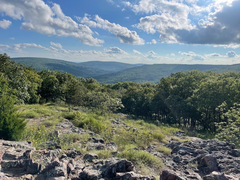
Hiking to the summit of Taum Sauk Mountain near Ironton, Missouri, offers an adventurous challenge with the reward of sweeping vistas from the state's highest point at 1,772 feet. The trail is a 3.5-mile loop through the rugged terrain of the St. Francois Mountains, part of the expansive Taum Sauk Mountain State Park. You’ll step onto well-marked paths that rise steadily over exposed rocks and shaded hardwood forests, where the wind can push as if testing your resolve.
The journey demands steady footing and moderate endurance with an elevation gain of about 500 feet. The terrain shifts between packed dirt, gravel, and steep rock sections that invite focus and respect. Forests whisper around you—the oaks and hickories stand firm, and maples dare you upward with their rustling leaves. Water trickles from hidden springs, urging you onward.
At the top, the landscape opens broadly. The Iron County hills stretch like an old, slow-moving current, green waves interrupted only by distant farms and hollows. The viewing platform offers a clear vantage, framing the St. Francois Mountains and Taum Sauk Hydroelectric Plant’s intriguing reservoirs.
Timing your hike early in the morning or late afternoon lets you feel the mountain’s changing moods—the warmth of sun against your skin and cool drafts that demand a steady grip. Proper footwear with good traction and reliable hydration are essentials. Packing light but prepared ensures you can focus on the climb without distraction.
This trail is an invitation to engage with nature fiercely itself: a place where the terrain doesn’t give way easily but rewards persistence with quiet grandeur. Whether you come for the exercise, the views, or both, Taum Sauk Mountain challenges and rewards in equal measure. Prepare well, move deliberately, and take in the summit’s vast perspective—a fitting payoff for the effort.
Nearby Trips
All Adventures
Boat Charters
Water Activities
Adventures near Ironton, Missouri
Discover the unique and memorable adventures that make Ironton, Missouri special.
Frequently Asked Questions
How long is the hike to the summit of Taum Sauk Mountain?
The loop trail is approximately 3.5 miles in length, typically completed within 2 to 3 hours depending on pace and breaks.
Is the hike suitable for beginners?
While the trail is moderate, beginners should be prepared for rocky terrain and steady elevation gain. Proper footwear and pacing make it accessible for most with reasonable fitness.
Are pets allowed on the trail?
Pets are permitted but must be kept on a leash. Ensure you bring enough water for your pet and be attentive to the trail conditions.
When is the best time to visit for photography?
Early mornings and late afternoons offer the best light and fewer crowds, lending themselves to striking landscapes and softer shadows.
Is there parking available near the trailhead?
Yes, there is a designated parking area at Taum Sauk Mountain State Park near the trail entrance with room for several vehicles.
Are restrooms available at the trailhead or summit?
Restrooms are available at the state park facilities near the trailhead but not on the summit itself, so plan accordingly.
Recommended Gear
Hiking boots
Provide necessary traction and ankle support on rocky and uneven surfaces.
Hydration system / water bottles
Ensures adequate water supply since there are no potable water sources on the trail.
Layered clothing
Adjusts to temperature changes from cool mornings to warm afternoons and wind exposure at the summit.
Microspikes or traction devices
Improves footing on icy or slippery rocks during winter months.
Local Insights
Hidden Gems
- "Castle Rock viewpoint along the trail offers a less crowded panorama with sheer cliffs dropping away below."
- "Lower reservoirs visible near the base hold small amphibia and bird species uncommon elsewhere."
Wildlife
- "Watch for white-tailed deer cautiously moving through the forest edges."
- "Eastern box turtles can sometimes be spotted along shaded trail sections."
History
"Taum Sauk Mountain has cultural significance as part of the ancient St. Francois Mountains and was historically used by indigenous peoples and early settlers for its mineral resources."