Exploring Grayling, Michigan: Why Booking with Grayling Recreation Authority Makes All the Difference
Grayling, Michigan blends rugged natural beauty with accessible adventure, from river paddling to forest trails. Booking with the Grayling Recreation Authority ensures you’re equipped with essential info, gear access, and expert insight to make your outdoor experience safe and unforgettable.
Adventure Tips
Wear Trail-Ready Footwear
The trails range from packed earth to rocky patches with roots; sturdy hiking boots with good traction will prevent slips.
Stay Hydrated and Time Your Hike
Carry at least 2 liters of water and aim to hike early morning or late afternoon to avoid midday heat and catch better light.
Check River Conditions Before Paddling
The Au Sable River’s current changes with rain and season—booking with the Recreation Authority gives you up-to-date info to plan safe trips.
Pack for Variable Weather
Northern Michigan can shift from sun to rain quickly; waterproof layers and sun protection are crucial year-round.
Exploring Grayling, Michigan: Why Booking with Grayling Recreation Authority Makes All the Difference
Grayling, Michigan offers a gateway to raw outdoor adventure where the forest challenges you with every step and rivers dare you to keep pace. The Grayling Recreation Authority isn’t just a booking service—they are your essential guide to experiencing this fierce northern wilderness with purpose and preparation.
Start with the Au Sable River, flowing with restless energy that carves through the landscape, offering paddlers both serenity and challenge. Whether you’re kayak-ready or prefer fishing along its banks, booking with the authority ensures you have access to the best launch points, equipment recommendations, and local river conditions.
For hikers, the nearby trails offer a practical mix of distances and terrain. Take the River Trail Loop: 5.2 miles of gentle elevation changes, mostly packed earth with occasional rocky patches, passing through dense pine groves and open hardwoods. Early morning or late afternoon hikes provide dappled sunlight filtering through the trees, the forest alive with birdsong and the occasional rustle of deer. The terrain commands respect—a few roots and steep inclines test your footing, making solid footwear a must.
The Recreation Authority takes the guesswork out of your trip, providing detailed maps, trail updates, and safety tips that turn ambiguity into confidence. Hydration advice, ideal hiking windows, and weather forecasts come standard with their booking packages, helping you avoid common pitfalls.
Mountain biking in Grayling is a practical adventure in itself. The trails range from moderate to challenging, with rolling terrain that pushes your endurance but rewards with wide clearings and north woods vistas. Booking with the Authority includes access to trail maintenance info and bike rentals tailored to the terrain.
Don’t overlook the local wildlife that watches silently from the underbrush or glides across wetlands—whitetail deer, bald eagles, and even elusive otters remind you that this wilderness is fiercely alive.
In all, Grayling is not about conquering nature but engaging with its raw force. Booking through the Grayling Recreation Authority arms you with knowledge, gear, and insider insight that keep your adventure safe, practical, and exhilarating. Let the forest test you, the river call you, and the trails teach you—Grayling awaits, and so should your plan.
Nearby Trips
All Adventures
Boat Charters
Water Activities
Adventures near Grayling, Michigan
Discover the unique and memorable adventures that make Grayling, Michigan special.
Frequently Asked Questions
What are the best trails in Grayling for beginners?
The River Trail Loop is ideal for beginners, offering 5.2 miles of mostly gentle terrain. It’s well-marked, forested, and provides scenic river views without steep elevation.
When is the Au Sable River safest for paddling?
Late spring through early fall offers the most stable river conditions. Avoid after heavy rains or thaw periods. The Grayling Recreation Authority provides current flow reports which are highly recommended.
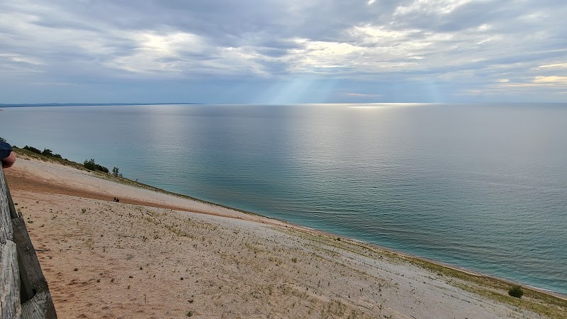
Are there any hidden viewpoints worth visiting?
Yes, the overlook near North Down River Trail gives a sweeping view of the Au Sable valley and is often overlooked by casual visitors. It’s a short moderate hike with rewarding panoramas.
Which wildlife species should I watch for during hikes?
Expect to see whitetail deer and a variety of songbirds. Bald eagles frequently soar above the river corridors. Keep an eye on wetlands for signs of otters or beavers.
How environmentally responsible is Grayling’s recreation area?
Grayling Recreation Authority actively promotes Leave No Trace principles. They manage trails and river access to minimize erosion and habitat disturbance while educating visitors.
What is the historical significance of Grayling’s outdoor spaces?
Grayling holds roots in logging and river transport history. Many trails follow old logging roads, and the Au Sable River was once a thoroughfare for timber rafting, a legacy that enriches the landscape’s story.
Recommended Gear
Hiking boots with ankle support
Protects feet on rocky, root-strewn trails and provides important traction in variable conditions.
Hydration pack or water bottles
Maintaining hydration is critical on all excursions, especially in summer heat or longer hikes.
Layered clothing system
Allows adaptation to swift temperature changes common in northern Michigan.
Insect repellent
Useful to deter mosquitoes and black flies prevalent during warm months.
Local Insights
Hidden Gems
- "North Down River Trail overlook"
- "Small fishing spots along secluded bends of the Au Sable River"
- "Quiet sections of the Hartwick Pines State Park nearby"
Wildlife
- "Whitetail deer"
- "Bald eagles"
- "River otters"
- "Great horned owls"
History
"Grayling's forests were vital to Michigan's early 20th-century logging economy, and many trails trace paths once used by loggers. The area's transformation into a recreational destination reflects this evolving human relationship with the land."