Remote Roads & Big Vistas: Overlanding the Magruder Corridor in Idaho
Experience the untamed beauty of Idaho’s Magruder Corridor, a 92-mile overland route where dense forests give way to expansive mountain valleys. This guide offers practical tips and vivid descriptions to help you prepare for an adventure that blends rugged wilderness with breathtaking views.
Pack extra water supplies
Water sources are few and far between along the corridor, so carry at least 3 liters per person per day to stay hydrated safely.
Use a high-clearance 4x4 vehicle
Rocky and uneven sections require clearance and traction. A 4-wheel-drive vehicle reduces risk of getting stuck on rough terrain.
Travel between late July and early October
Prioritize this window to avoid snow closures and enjoy milder weather, but be prepared for sudden temperature drops.
Carry offline maps and GPS
Cell phone reception is almost nonexistent; reliable navigation tools are crucial to stay on route and avoid getting lost.
Remote Roads & Big Vistas: Overlanding the Magruder Corridor in Idaho
The Magruder Corridor Scenic Byway stretches 92 miles across Idaho's rugged backcountry, threading between the Selway-Bitterroot Wilderness and the Frank Church-River of No Return Wilderness. This remote, unpaved road challenges overlanders with its raw landscapes—a place where dense forests whisper stories and mountain ridges lay open, daring you to explore deeper and stay longer.
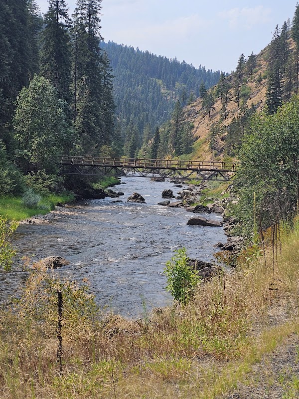
Expect a journey carved by nature’s fierce independence. The route’s elevation ranges from roughly 3,800 to nearly 6,000 feet, offering varied terrain from smooth dirt tracks to rocky stretches that demand focus and cautious driving. Trees crowd the beginning of the route, their branches leaning in like old friends warning to respect the solitude ahead. As the road unfolds, the forest thins and reveals vast valleys where rivers rush with urgency, pushing forward with relentless current beneath you.
Though considered one of the more accessible wild roads in Idaho, the Magruder Corridor calls for preparation. Water is scarce outside small ranger stations, so bring ample supplies. Vehicles need good clearance and sturdy tires, especially for the steeper climbs near Packer John Mountain. The corridor’s layers shift—heat by day, cold by night—so pack clothing in adaptable layers to stay comfortable and safe.
Adventure here means engaging with a land unfettered by crowds. Campsites are primitive, but each offers a chance to witness sky-swathing stars uninterrupted by light pollution. Wildlife keeps a watchful eye, from elusive elk blending into thick stands to eagles soaring overhead, surveying their domain.
Plan your timing carefully: late summer to early fall reduces the threat of early snow but may bring rapid weather swings. Night falls quickly, and cell service is non-existent; navigation demands reliable maps or GPS units programmed offline.
Overlanding the Magruder Corridor isn’t about conquering the road—it’s about respecting it, listening to the wild’s rhythm, and allowing the mountain vistas and rushing rivers to redefine your pace. Here, adventure meets practicality in every mile covered, and every vista earned.
Nearby Trips
All Adventures
Boat Charters
Water Activities
Adventures near Grangeville, Idaho
Discover the unique and memorable adventures that make Grangeville, Idaho special.
Frequently Asked Questions
Is the Magruder Corridor open to all vehicles?
No, only high-clearance 4x4 vehicles are recommended. The rugged terrain includes rocky hills and uneven road surfaces that can damage passenger cars.
Are there any services or fuel stops along the corridor?
No fuel or services are available on the route itself. The closest reliable town for refueling and supplies is Grangeville, Idaho, so plan accordingly before departure.
What permits or fees are required to travel the corridor?
There are no fees or permits required for the Magruder Corridor itself, but camping in designated wilderness areas may require a free permit, which can often be obtained at trailheads or ranger stations.
When is the best time to attempt overlanding the Magruder Corridor?
Late July through early October is ideal when the road is generally clear of snow and weather is more stable, reducing the risk of closures or dangerous conditions.
Is it safe to camp along the corridor?
Yes, primitive camping is allowed in designated areas. Keep in mind that bears and other wildlife are active, so use proper food storage techniques and follow Leave No Trace principles.
Can I hike portions of the corridor?
Yes, the corridor offers access to multiple trails and viewpoints. Hikes range from short walks to multi-day backcountry treks, all demanding solid preparation due to rugged and remote conditions.
Recommended Gear
High-clearance 4x4 vehicle
Mandatory for safely handling rugged, uneven surfaces and steep inclines throughout the route.
Hydration system with 3+ liters capacity
Staying hydrated is critical; the route has limited water sources, especially in dry months.
Layered clothing
Temperatures can swing rapidly; layers help maintain comfort from hot days to chilly evenings.
Portable GPS with preloaded maps
Essential for navigation because cellular signals are virtually non-existent on the corridor.
Local Insights
Hidden Gems
- "Hiker’s Peak viewpoint offers panoramic vistas of the Salmon River Valley, often overlooked by travelers focused on the main corridor."
- "The Ghost Ranger Station, an abandoned Forest Service outpost, provides a glimpse into the area's historical management."
Wildlife
- "Keep an eye out for Roosevelt elk moving silently through the forests and occasional bald eagles circling the river canyons."
- "Mountain lions are present but elusive—stay aware and avoid nocturnal hikes."
History
"The Magruder Corridor follows historic routes used by Native American tribes and early settlers. It was later developed for forest management but remains largely wild, preserving a glimpse of Idaho’s untamed past."
