Explore the rugged ascent to Celaque National Park’s cloud forests near Gracias, Honduras. This hike offers both thrilling natural beauty and a practical challenge, weaving through misty pines and moss-thick oaks to reach sweeping mountain vistas.
Start Early to Beat the Fog
Begin your hike at dawn to avoid dense midday fog that reduces visibility and moistens the trail, making footing tricky.
Hydrate Thoroughly
Carry at least 2 liters of water per person; despite the moisture-rich environment, the climb can quickly dehydrate you.
Wear Grip-Ready Footwear
Choose waterproof hiking boots with good traction as the trail shifts between rocky paths and slippery mud.
Hire a Local Guide
Guides from Gracias provide valuable insight on trail conditions and natural features, enhancing both safety and experience.
Trail to the Clouds: Hiking Through Celaque’s Legendary Cloud Forests
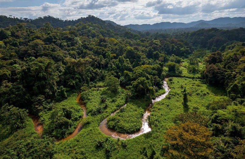
Rising sharply from the rolling hills near Gracias, Honduras, Celaque National Park is a call to adventurers who seek more than just a day hike. Climbing to the cloud forests of Cerro Las Minas—the park’s crown jewel and the highest peak in Honduras at 2,870 meters—offers a raw mountain experience where fog-laden trees drip with life and the wind dares you to keep moving forward. The trail itself stretches roughly 12 kilometers round trip, with an elevation gain of about 850 meters. It’s a gradual ascent through thick pine and oak forests that transition into the dense, moisture-saturated canopy of cloud forest.
Prepare to feel the forest’s pulse as moss-covered branches reach toward you like watchful sentinels. The air thickens with mist, and the ground beneath your boots turns soft with decomposing leaves and damp earth. Streams appear suddenly, daring you to find their crossing points as they push with stubborn currents. The trail weaves between rhododendron and wild orchids, each step inviting attentiveness.
Timing your hike is key—start early to avoid the mid-day fog that can cloak the path in near invisibility and bring a slickness that demands cautious footing. Wear sturdy, waterproof hiking shoes; the terrain shifts from rocky sections to muddy slopes. Carry enough water—at least 2 liters—because though the forest seems to breathe moisture, the altitude and climb can dehydrate you quickly.
Beyond the physical challenge, the reward is panoramic views that stretch over lush valleys and distant peaks, often framed by drifting clouds that seem to caress the ridges. Birdsong becomes clearer here, almost defiant in the moist air. Local guides recommend spending a night in the nearby town of Gracias beforehand to acclimate and gather supplies.
This hike to Celaque’s cloud forests is a tangible encounter with nature in a form fiercely itself—unpredictable and alive. It’s a test of endurance and respect for the environment, offering an experience that carries you through shifting weather, vibrant ecosystems, and the satisfying ache of high-altitude effort. Plan wisely, move steadily, and let the forest communicate its secrets on every step.
Nearby Trips
All Adventures
Boat Charters
Water Activities
Adventures near Gracias
Discover the unique and memorable adventures that make Gracias special.
Frequently Asked Questions
How long does it take to hike to the cloud forests in Celaque?
The hike typically takes between 5 to 7 hours round trip, depending on fitness and pace, including breaks for rest and photography.
Is the trail suitable for beginners?
While the path is well-marked, the elevation gain and distance make it more suitable for hikers with moderate experience or better fitness levels.
Do I need a guide to hike in Celaque National Park?
Though not mandatory, hiring a local guide is strongly recommended for navigation help, safety, and to enrich your understanding of the environment.
What wildlife can I expect to see on this hike?
Bird species like the resplendent quetzal and various hummingbirds are common, along with small mammals and abundant insect life.
Are there accommodations near the trailhead?
Yes, the town of Gracias offers several guesthouses and lodges where hikers can stay before and after the trek.
What should I do if the weather turns bad during my hike?
Return promptly if conditions worsen. The clouds can thicken quickly, reducing visibility and making the trail slippery and hazardous.
Recommended Gear
Waterproof Hiking Boots
Keeps feet dry and provides grip on the slippery, uneven terrain common throughout the trail.
Light Rain Jacket
Protects against spring showers and mist without overheating during the climb.
Hydration System or Water Bottles
Hydrating frequently is essential at altitude where moisture loss accelerates, regardless of the humid environment.
Sun Protection (Hat & Sunscreen)
Even cloud cover can’t block UV rays at high elevations, especially in summer.
Local Insights
Hidden Gems
- "Mirador La Piedra, a lesser-known vantage point offering a sweeping view of the lower valleys with fewer visitors."
- "The ancient La Tigra cave, an archaeological site within the park, holding cultural significance."
Wildlife
- "Look for the elusive Resplendent Quetzal in the upper cloud forest layers early in the morning."
- "Listen for the calls of the colorful motmot bird, a resident of this moist environment."
History
"Celaque National Park was established to protect the rich biodiversity and cultural heritage of the Lenca people, indigenous to the region."