Conquer the Annual Glendora Mountain Road Hike: Your Guide to Adventure and Preparation
The Annual Glendora Mountain Road Hike offers a rigorous 7.3-mile ascent through the San Gabriel Mountains with over 3,000 feet of elevation gain. Challenging yet accessible, this unique hike invites adventurers to experience sweeping valley views and forested mountain edges while testing stamina and preparation.
Hydrate Early and Often
Carry at least 2 liters of water and sip regularly to avoid dehydration, especially as the climb heats up midday.
Wear Breathable, Grippy Footwear
Choose trail runners or hiking shoes with solid traction to handle paved inclines and rocky side paths.
Start Early to Beat the Heat
Begin your hike in the cool morning hours to avoid exposure to the strong sun and reduce fatigue.
Prepare for Steady Elevation Gain
Expect consistent uphill with occasional steep pitches; maintain a comfortable pace and use walking poles if needed.
Conquer the Annual Glendora Mountain Road Hike: Your Guide to Adventure and Preparation
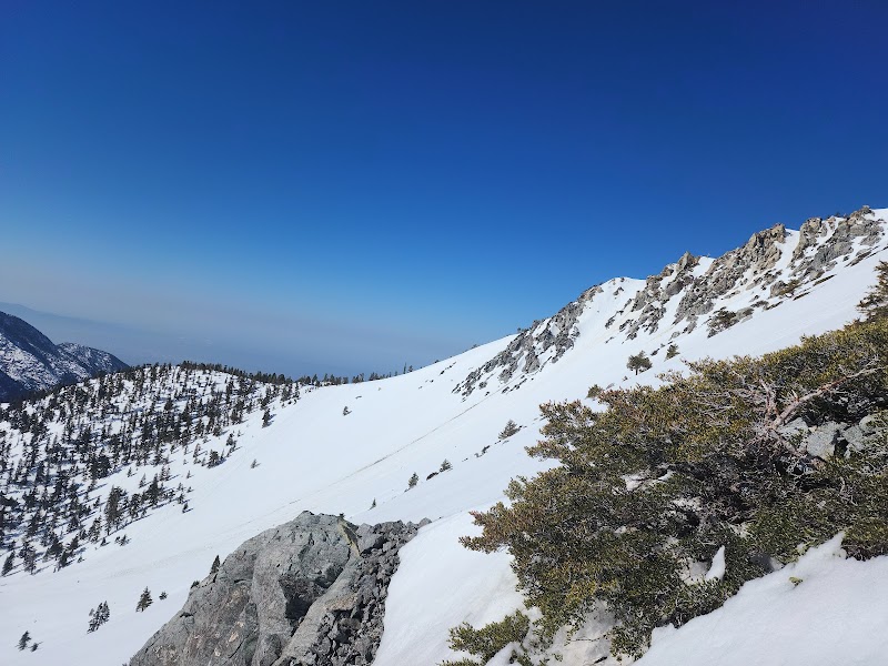
Each October, the Annual Glendora Mountain Road Hike unspools along a challenging 7.3-mile stretch of road that climbs steadily through the San Gabriel Mountains just outside Glendora, California. This route is not your typical forest trail; it’s a rugged artery of asphalt that dares you to test your endurance against steep switchbacks and wide-open vistas. Elevation gains surpass 3,000 feet, pushing hikers from the streets of Glendora at about 1,000 feet up to the edge of the forested San Gabriel peaks cresting around 4,200 feet. The roadway, closed to vehicles during the event, becomes a playground for those eager to engage with a mountain fiercely itself — raw, exposed, yet spectacular.
The terrain is primarily paved but varies from smooth stretches to cracked, weather-worn surfaces shadowed by chaparral and stands of ancient oaks that flirt with the sunlight. As you ascend, the dense urban hum fades and the wind picks up, nudging you upward alongside shrubs that lean into the breeze. Low scrub sometimes crowds the narrow shoulder, making footing on the occasional side path rocky and uneven. At key points, towering pines stand like guards over incredible panoramas of the valley below, where city grids flatten out like an open map, waiting.
The hike’s rhythm is relentless but rewarding. It asks for steady pacing, conscious hydration, and respect for the mountain’s honest challenge. Mornings bring cool air that invigorates muscles, but midday sun demands a broad-brimmed hat and sunscreen. Water carried in adequate supply is non-negotiable—the climb does not forgive dehydration. Multiple rest stops are available, staffed with volunteers handing out encouragement and basic first aid, but preparedness remains your best ally.
Aside from physical readiness, practical footwear is crucial; trail runners or sturdy hiking shoes with good grip will handle both the pavement and surging side trails. Lightweight layers serve best here, as the climb begins cool and can warm considerably with exposure. For those planning to join the event, registration and logistics details are available months in advance, with clear markers and safety protocols in place.
This event is an ideal way to experience the San Gabriel Mountains' rugged edge with a crowd of motivated hikers. No matter your level, it’s an invitation to engage with terrain that challenges and rewards—reminding every adventurer, whether casual or seasoned, that the mountain is not to be conquered but understood and respected. The road may be closed to vehicles, but it's wide open for those willing to meet it with steady feet and determination.
If you’re looking to test stamina with views that hold nothing back, the Annual Glendora Mountain Road Hike in Glendora, California is a must-do. Come prepared, pace yourself, and enjoy the mountain’s raw invitation to push onward.
Nearby Trips
All Adventures
Boat Charters
Water Activities
Adventures near Glendora, California
Discover the unique and memorable adventures that make Glendora, California special.
Frequently Asked Questions
Is the Annual Glendora Mountain Road Hike suitable for beginners?
The hike is challenging due to steady elevation gain and length, but beginners with solid fitness and preparation can complete it. Pace yourself, take breaks, and bring plenty of water.
Are there any facilities or aid stations along the route?
During the event, volunteers staff aid stations offering water and first aid at intervals along the course. Outside the event, facilities are limited, so come prepared.
Can I access the hike outside the annual event date?
Yes, the Glendora Mountain Road is open to hikers most of the year but closed to vehicles only during the event weekend. Check local signage for closures.
What wildlife might I encounter on this hike?
Expect to see birds such as scrub jays and hawks, occasional lizards warming on rocks, and if lucky, glimpses of mule deer along quieter forested patches.
Is this hike dog-friendly?
Dogs are allowed but must be on leash. The climb may be strenuous for some pets, so bring water and gauge your dog’s endurance.
Are there safer or easier alternative routes near Glendora Mountain Road?
Yes, the nearby East Fork Trail offers a less steep, more shaded forest path for those looking for gentler terrain.
Recommended Gear
Hydration Pack or Water Bottles
Critical to stay hydrated given the climb’s length and sun exposure.
Trail Running Shoes or Hiking Boots
Provides grip and support for ascending asphalt and uneven side trails.
Sun Hat and Sunscreen
Protects from direct sun during exposed sections of the road.
Lightweight Layered Clothing
Helps regulate body temperature as the hike shifts from cool start to warmer climb.
Local Insights
Hidden Gems
- "Hidden overlook at mile 4 with bench seating, offering panoramic views of the San Gabriel foothills."
- "A quiet oak grove near the 3,000-foot mark where hikers often spot local wildlife."
Wildlife
- "California scrub jay"
- "mule deer"
- "western fence lizard"
- "red-tailed hawk"
History
"Glendora Mountain Road was originally a fire access route before becoming a popular hiking corridor; its pavement remains a reminder of its functional past."