Beyond the Presidential Range: Best Day Hikes in White Mountain National Forest
Escape the crowds of the Presidential Range and explore White Mountain National Forest’s quieter trails. Discover scenic ridges, hidden viewpoints, and forested paths that challenge and inspire with every step.
Carry Enough Water
Reliable water sources can be sparse on these trails. Plan for at least 2 liters per person and consider a lightweight filtration system if extending your hike.
Wear Supportive Footwear
Expect rocky and uneven terrain with occasional steep sections. Hiking boots or sturdy trail shoes with ankle support reduce injury risk.
Early Starts Are Key
Afternoon showers are common in summer and fall. Beginning your hike early maximizes daylight and reduces exposure to storms.
Practice Leave No Trace
These lesser-traveled routes require responsible use. Pack out all trash and stay on established trails to protect sensitive habitats.
Beyond the Presidential Range: Best Day Hikes in White Mountain National Forest
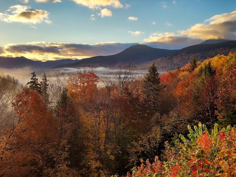
Venture beyond the well-trodden Presidential Range to uncover some of White Mountain National Forest’s lesser-known, yet equally compelling day hikes. These trails offer a mix of old-growth forests, rugged ridges, and quiet mountain ponds, perfect for hikers seeking adventure without the crowds. Each path challenges you to engage with a landscape fiercely itself—streams daring you to cross, winds pushing you forward, and woods that seem alive with whispered history.
Start with the Osceola Ridge Trail, a 5.4-mile moderate loop that ascends through dense pine and fir, presenting patches of rocky terrain and steady elevation gain of 1,700 feet. The trail’s crest rewards you with wide views across the Pemigewasset Wilderness, where rolling hills stretch in uneven layers. Early mornings highlight songbirds and shy chipmunks darting at your feet, while late afternoon often ushers in cooling breezes that hint at the coming dusk.
For those craving a steadier pace, the Welch-Dickey Loop offers a 4.4-mile hike featuring exposed ledges with panoramic views of the Squam Lake area and beyond. The trail’s rugged rubbly sections will test your footing but not your nerve. Look out for wild blueberries pitching their tart sweetness along sunlit stretches. The elevation gain approaches 1,500 feet, providing invigorating climbing balanced by manageable descents.
If solitude is your goal, the Carr Mountain Trail sits on the forest’s quieter edge. This 7.6-mile out-and-back climbs just over 2,000 feet, winding through moss-laden hardwoods and across babbling creeks that demand careful steps. The summit’s broad, open ledges are unmarked but known to locals, offering sweeping views that include distant ranges and the patchwork farmland below. This trail speaks softly but rewards handsomely.
Preparation is key: sturdy footwear with axle support is necessary for rocky, uneven ground. Water sources are limited and unpredictable beyond well-marked springs, so carry ample hydration. Time your trips to start early, sidestepping afternoon thunderstorms common in summer. Daylight wanes swiftly come fall, making daylight management crucial.
These hikes require respect for the terrain’s raw character. The forest here isn’t a backdrop; it’s a participant—tough, vibrant, and fully engaged with your journey. In return for your preparations and awareness, the White Mountain National Forest outside the Presidential Range delivers adventure, insight, and a genuine connection to nature that only an engaged hiker can earn.
Nearby Trips
All Adventures
Boat Charters
Water Activities
Adventures near Franconia
Discover the unique and memorable adventures that make Franconia special.
Frequently Asked Questions
Are there any lesser-known viewpoints on these trails?
Yes, the Carr Mountain Trail offers hidden rocky outcrops with sweeping views of distant ranges rarely visited by casual hikers. These points are unmarked but reachable via side paths near the summit.
What wildlife might I encounter?
Expect to see white-tailed deer, red squirrels, and a variety of songbirds. In quieter sections, black bears occasionally roam, so make noise and carry bear spray during warmer months.
How do these hikes compare to those in the Presidential Range?
These trails provide less elevation and fewer exposed ridges, making them more approachable for hikers seeking solitude without the intense weather conditions often found on Presidential summits.
What environmental protections are in place here?
The area is managed to minimize human impact; camping is restricted to designated zones, and all visitors are urged to practice Leave No Trace to protect delicate habitats.
Are dogs allowed on these trails?
Dogs are permitted if leashed. Trail conditions can be rugged, so ensure your pet is fit for the terrain and always clean up after them.
When are bugs most active, and how to manage them?
Insects peak late spring through early summer. Wearing long sleeves, using insect repellent, and timing hikes for early morning or late afternoon can reduce bites.
Recommended Gear
Trail Boots
Provide ankle support and grip for rocky or uneven trails common outside the main range.
Hydration System
A hydration bladder or water bottles to carry at least two liters; water sources are unreliable.
Layered Clothing
Weather changes quickly, so dress in moisture-wicking base layers and insulating mid-layers.
Headlamp or Flashlight
Essential for hikes beginning early or finishing late; short daylight hours in cooler seasons.
Local Insights
Hidden Gems
- "Carr Mountain’s unmarked summit ledges with expansive views"
- "Quiet ponds near Osceola Ridge that reflect starry skies at night"
Wildlife
- "black bears"
- "white-tailed deer"
- "red squirrels"
- "ruffed grouse"
History
"This region was historically logged in the early 1900s; some trails follow old logging roads, revealing scars slowly healing under decades of forest regrowth."