Tour de Davis: A Practical Guide to Exploring Davis, California’s Scenic Paths
Tour de Davis offers a balanced route combining mild elevation and diverse terrain in Davis, California, perfect for both casual hikers and cyclists. This loop invites you to experience urban nature, riparian paths, and farmlands, with practical tips for hydration, gear, and timing to make the most of your adventure.
Stay Hydrated on Open Sections
Parts of the route lack tree cover, especially through farmland. Carry at least one liter of water per hour during warm months to avoid dehydration.
Time Your Ride for Morning or Evening
Davis can get hot in summer afternoons. Plan your trip early or late in the day for cooler temperatures and softer light for photography.
Use Hybrid or Trail-Ready Bikes
While much of the path is paved, some sections transition to packed gravel. Bikes with versatile tires provide better control on mixed surfaces.
Fuel Up in Town
Coordinate your outing with visits to local markets or cafes in Davis to replenish energy after your adventure without detouring far from the route.
Tour de Davis: A Practical Guide to Exploring Davis, California’s Scenic Paths
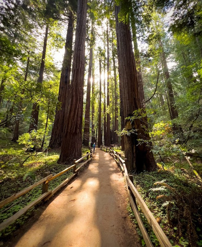
The Tour de Davis isn’t just a route; it’s an invitation to engage with Davis, California’s landscape on foot or bike, where the city’s accessible charm meets refreshing pockets of nature. Stretching roughly 7 miles in a loop, this route covers mixed terrain that’s mostly flat with gentle rises—ideal for casual hikers, cyclists, and seasoned adventurers looking for a manageable outing with a local twist. Expect paved bike paths weaving through tree-lined streets, open farmland that seems to stretch toward the horizon, and subtle glances of natural contours that quietly challenge your pace.
Starting near central Davis, the journey offers more than just physical activity. You move alongside riparian corridors where Willow trees lean toward you as if to whisper, "Keep going." A network of channels cuts through the landscape, daring you to slow and admire where water and land interact—especially in spring when the flow swells, pushing forward with gentle insistence.
Though the route’s elevation gain hovers under 300 feet, small inclines provide moments to catch your breath and scan the distance. On clear days, the Sierra Nevada silhouette lingers faintly on the skyline, a reminder of California’s diverse geography. Terrain varies: urban paths shift to rural gravel alongside orchards, soft underfoot but manageable with sturdy shoes or hybrid bikes.
Hydration is key; the route’s open stretches offer limited shade. Early mornings or evenings in spring and fall present the most comfortable temperatures, while summer heat demands extra preparation—lightweight clothing and ample water are non-negotiables here. Footwear wise, aim for dependable sneakers or cycling shoes with good grip—surface changes can surprise you.
Planning around local farmer’s markets or coffee stops injects practicality and pleasure into your tour, allowing you to refuel and rehydrate without straying far from the trail. The city’s commitment to bike infrastructure means you’re never far from a repair station or rest stop.
The allure of Tour de Davis lies not in harsh challenges but in the steady companionship of environment and city life that flows effortlessly together. Here, nature and human design converse in measured pace, inviting exploration without overwhelming. Whether mapping your route or simply following the signs, the experience encourages respect for a landscape that remains fiercely itself—accessible, active, and quietly alive.
Nearby Trips
All Adventures
Boat Charters
Water Activities
Adventures near Davis, California
Discover the unique and memorable adventures that make Davis, California special.
Frequently Asked Questions
Is the Tour de Davis suitable for beginner cyclists?
Yes. The route is mostly flat with gentle inclines, making it accessible to beginner cyclists who have basic bike handling skills. Stick to the paved paths during initial rides and avoid peak heat hours.
Are there restrooms or water refill stations available along the route?
Restrooms and water refill stations are limited along the route, so plan ahead by starting in central Davis near parks or commercial areas where these facilities are accessible.
What wildlife might I see along the Tour de Davis?
Look for great blue herons and red-winged blackbirds near the water channels. In spring, migrating songbirds become active, and small mammals such as rabbits may dart through the vegetation.
Can the route be completed year-round?
Yes, with preparation. Winter may bring muddy conditions, and summer demands sun protection and hydration. Spring and fall offer the most comfortable weather.
Is the Tour de Davis family-friendly?
Definitely. The moderate distance and flat terrain make it suitable for families, though younger children may need interruptions and sunscreen due to exposed areas.
Are there any unique historical or cultural landmarks along the route?
The tour passes near the Davis Arboretum and historic portions of downtown with plaques and public art offering local history insights, blending nature with community heritage.
Recommended Gear
Hydration Pack or Water Bottles
Crucial for staying hydrated on exposed sections, especially during warmer months with limited access to refill stations.
Sturdy Trail Shoes or Hybrid Bike
Ensures comfort and grip across paved and gravel surface transitions along the route.
Lightweight Layered Clothing
Protects from fluctuating temperatures and wind, allowing adaptation throughout the journey.
Sun Protection (Hat, Sunscreen)
Blocks strong midday sun during exposed stretches when shelter is scarce.
Local Insights
Hidden Gems
- "The Channel Islands along the water roads offer peaceful benches and hidden flora not immediately obvious from main paths."
- "A small wooden bridge near the northern loop presents a quiet spot often missed where you can hear the creek’s steady murmur."
Wildlife
- "Western pond turtles sun themselves on logs by water edges."
- "Seasonal sightings of white-tailed kites hunting above fields."
History
"Davis evolved as an agricultural college town, with many trails tracing former farming routes now integrated into urban greenways."