Traversing Shining Rock Wilderness: Panoramic Peaks and Quiet Trails Near Canton, NC
Explore the Shining Rock Wilderness near Canton, NC—a rugged expanse of rocky peaks and forested paths offering panoramic Blue Ridge views. This guide equips you with practical tips to prepare for a challenging yet rewarding hiking experience amid some of North Carolina’s most serene mountain landscapes.
Start Early to Avoid Afternoon Storms
Summer afternoons bring sudden storms; beginning hikes early improves safety and maximizes daylight for the trail.
Wear Trail Shoes with Good Traction
The trail varies from rocky to root-covered; shoes with solid grip prevent slips and protect your ankles on uneven ground.
Carry Enough Water and a Filter
Water sources can be scarce or unreliable; bring at least 2 liters and a portable filter for longer hikes.
Map Your Route and Monitor Your Location
Dense foliage and intersecting paths make navigation tricky. Use a physical map and GPS to stay on track.
Traversing Shining Rock Wilderness: Panoramic Peaks and Quiet Trails Near Canton, NC
Shining Rock Wilderness, located just outside Canton, North Carolina, invites hikers to step into a world where rugged peaks and tranquil forests command respect. The wilderness covers over 18,000 acres of steep ridges, crystalline streams, and rocky outcrops that dare you to tread carefully and attentively. Trails here offer a direct connection to nature fiercely itself—a place where every step along the forested paths or jagged summits challenges your endurance and rewards you with sweeping views.
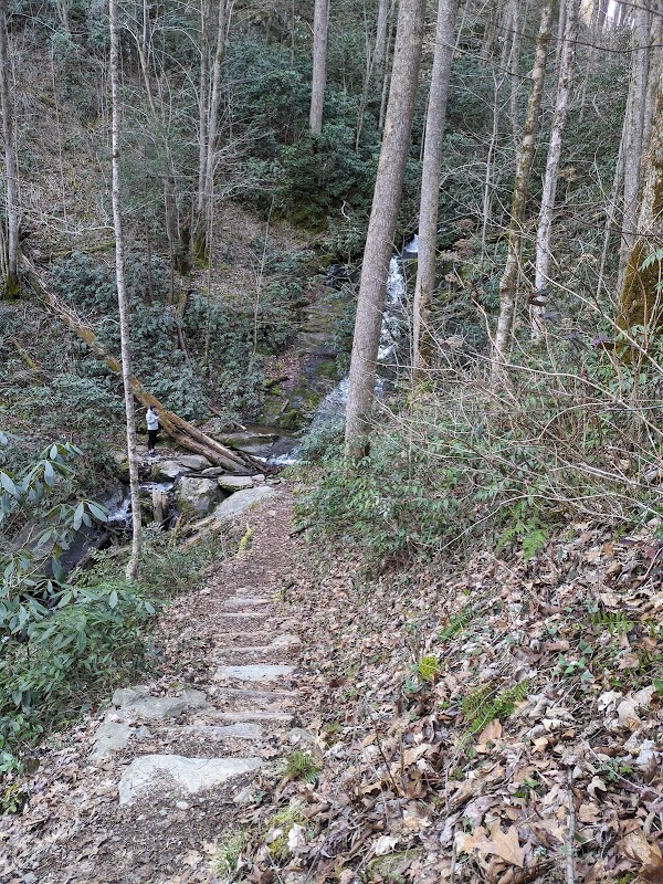
Start your adventure on the Art Loeb Trail, a demanding 30.1-mile route that snakes through the wilderness with nearly 6,000 feet of elevation gain. Many hikers opt for shorter sections, such as the 6-mile out-and-back leg to Shining Rock, a massive quartzite formation gleaming above dark green firs. The ground underfoot shifts between loose rock, packed dirt, and exposed roots, requiring sturdy, tread-gripping footwear to navigate safely.
As you ascend, the forest changes its character: spruces and firs stand tall, branches whispering secrets. Streams push forward beside the trail, their currents clear and bold, urging you onward. Above the treeline, the wind tests your balance and resolve, while panoramic views of the Blue Ridge Mountains unfold like a natural amphitheater, every ridge a new chapter in the story of the wilderness.
To tackle the terrain, plan for variable weather—layers are essential since temperatures can swing rapidly. Carry plenty of water; springs and streams may be sparse in dry months. Start early to avoid afternoon storms common in summer, and keep trail maps or GPS accessible as the dense foliage can disorient. Respect the area’s fragile environment by following Leave No Trace principles.
Whether you’re here for the invigorating challenge or the tranquility of the forest, Shining Rock Wilderness offers a measured balance—requiring preparation and respect but delivering unmatched mountain serenity and views. The wilderness doesn't surrender its beauty easily; it rewards those ready to meet it on its terms, step by step.
Nearby Trips
All Adventures
Boat Charters
Water Activities
Adventures near Canton, North Carolina
Discover the unique and memorable adventures that make Canton, North Carolina special.
Frequently Asked Questions
What is the best entry point for hiking in Shining Rock Wilderness?
Many hikers access the wilderness via the Art Loeb Trailhead at Daniel Boone Boy Scout Camp Road near Pisgah National Forest, which offers a direct route to Shining Rock and surrounding peaks.
Are dogs allowed on the trails?
Yes, dogs are permitted but must be kept on a leash. Be aware that some terrain may be tough for pets, and carry enough water for both yourself and your companion.
Is camping allowed within Shining Rock Wilderness?
Yes, backcountry camping is permitted but only in designated areas to protect the fragile ecosystem. Campfires are restricted, so plan accordingly.
What wildlife might I encounter here?
Expect to see white-tailed deer, black bears, and a variety of bird species. Maintain a respectful distance and store food properly to avoid attracting bears.
How difficult is the hike to Shining Rock summit?
The hike to Shining Rock involves about 6 miles round trip with roughly 1,800 feet of elevation gain. It’s moderately challenging, best suited for hikers with some experience.
Are there facilities or water sources along the trail?
Facilities are minimal. Some natural water sources exist but may not be reliable year-round. Always carry your own water and filtration if you plan extended hikes.
Recommended Gear
Sturdy Hiking Boots
Provides ankle support and grip on loose rock and uneven surfaces prevalent in the wilderness.
Layered Clothing
Allows for adjustments as temperatures shift quickly from trailhead to summit or with passing weather.
Hydration System or Water Bottles
Keeps you hydrated on long stretches where reliable water sources can be sparse.
Compact First Aid Kit
Essential for managing scrapes, blisters, or minor injuries encountered on rough terrain.
Local Insights
Hidden Gems
- "Hidden Falls, a quiet stream cascading into a small pool mid-trail, perfect for a cooling rest."
- "Looking Glass Rock viewpoint, visible from certain ridges, offers a lesser-crowded experience outside main summit vistas."
Wildlife
- "Black bears frequently roam these woods, especially near berry patches in late summer."
- "Northern flying squirrels, mostly nocturnal, but their rustling can be heard among the canopy."
History
"The wilderness area was designated in 1964, preserving traditional Cherokee hunting and gathering grounds alongside early Appalachian settlers’ trade routes."