Scenic Drives and Hidden Trailheads Around Blairsville, Georgia
Explore Blairsville’s scenic drives that wind through the Blue Ridge foothills and uncover hidden trailheads offering quiet waterfalls and forest views. This guide combines adventure with practical tips to help you plan an accessible yet invigorating mountain escape.
Stay Hydrated and Bring Snacks
Mountain trails can extend longer than expected, so carry at least two liters of water and energizing snacks to maintain energy.
Wear Sturdy Footwear
Trails feature rocky sections and exposed roots; hiking boots or trail runners with grip reduce risk of slips.
Start Early or Late
To avoid midday heat and crowds, aim to begin hikes early in the morning or mid-afternoon for better light and solitude.
Download Offline Maps
Cell service is patchy on trails and scenic routes; offline GPS or printed maps help with navigation.
Scenic Drives and Hidden Trailheads Around Blairsville, Georgia
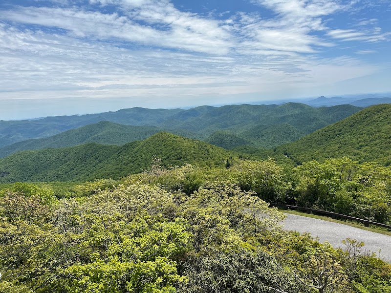
Blairsville, Georgia, in the heart of the Blue Ridge Mountains, offers a blend of scenic drives that stretch along ridges and valleys, alongside lesser-known trailheads that invite exploration beyond the usual paths. The roads here curve purposefully, inviting you to slow down and take in sweeping views of forest-clad hills where pockets of sunlight play along the leaves. Start with the winding Richard B. Russell Scenic Highway, where gusts from mountain rivers dare you closer to overlooks revealing miles of unbroken wilderness.
For those looking to stretch legs, hidden trailheads around Vogel State Park and Brasstown Bald challenge with well-maintained paths cutting through rhododendron thickets and through sections of old growth forest. The Arkaquah Trail, at 5 miles round-trip with a 750-foot elevation gain, offers a straightforward hike to a waterfall that commands quiet respect, its cascade pushing forward relentlessly. Expect uneven terrain peppered with roots and occasional rocky patches—trail shoes with good tread are a must.
Behind every turn, nature asserts itself as fiercely itself—trees bend in the wind, the Nottely River humbly charts its course, and wildflowers nod in time with the breeze. Afternoon light is often best, bringing out the warm tones of the forest floor and illuminating views from vistas like the Brasstown Bald summit trail. Timing your drive or hike outside of peak hours ensures a quieter, richer experience.
Be ready to pack water, snacks, and layers—mountain weather can shift quickly, dropping temperatures without warning. Many trails have limited cell reception, so a trail map or GPS device is prudent. Blairsville’s scenic drives and hidden trailheads offer both the quiet thrill of discovery and manageable challenge—perfect for anyone eager to step into a wild, vibrant landscape with both feet grounded firmly on practical preparation.
Nearby Trips
All Adventures
Boat Charters
Water Activities
Adventures near Blairsville, Georgia
Discover the unique and memorable adventures that make Blairsville, Georgia special.
Frequently Asked Questions
Are the scenic drives accessible year-round?
Yes, most scenic drives around Blairsville are accessible year-round. However, occasional winter storms may cause temporary road closures on higher elevations like Brasstown Bald Road, so it's wise to check local conditions ahead of time.
What kind of wildlife might I encounter on these trails?
Hikers may spot white-tailed deer, wild turkeys, and if fortunate, a black bear at a distance. Birdwatchers should keep an eye out for pileated woodpeckers and the occasional hawk soaring above.
Are there any historical sites along these drives or hikes?
Blairsville and the surrounding area have roots in early Cherokee settlements, with some old homestead sites and cemeteries near trails. While most are unmarked, local museums in Blairsville provide context on the region’s cultural past.
Is parking available at hidden trailheads?
Parking is limited at many hidden trailheads; arrive early on weekends to secure a spot. Some areas require a small fee or Georgia state park pass, especially within Vogel State Park.
What environmental practices should I follow while exploring?
Stick to marked trails to prevent erosion, pack out all trash, and avoid disturbing plants or wildlife. This area’s delicate mountain ecosystem depends on respectful visitor behavior.
Can these drives and hikes be done with children or novice hikers?
Many trails are family-friendly, though those with young children may prefer shorter loops like those in Vogel State Park. On drives, frequent pull-offs and overlooks offer opportunities to stretch legs and enjoy scenery safely.
Recommended Gear
Hiking Boots
Provides support and traction on rocky, root-filled trails.
Hydration Pack or Bottles
Ensures consistent hydration, vital for mountain hikes.
Layered Clothing
Prepares you for variable mountain weather, allowing adjustments for temperature.
Trail Map or GPS Device
Addresses patchy cell service and guides navigation on lesser-known trails.
Local Insights
Hidden Gems
- "Trackrock Campground trailhead accesses some of the less traveled paths with peaceful forest walks."
- "The lower sections of the Arkaquah Trail near the creek feature quiet pools ideal for a rest stop."
Wildlife
- "Look for signs of elusive Southern Appalachian salamanders in moist, shaded areas."
- "Raptors like red-tailed hawks use the thermals created by valley winds—watch the skies near ridges."
History
"Blairsville sits near ancestral Cherokee lands, and remnants of old pioneer routes influence current trail layouts. This blend of histories enriches the landscape’s story."