Tracing Trails: The History and Adventure of the Old Toll Road from Black Mountain to Mount Mitchell
Venture along the Old Toll Road from Black Mountain to Mount Mitchell and uncover a historic path that climbs through dense forests and rugged terrain. This trail offers a challenging yet rewarding journey, blending rich history with the untamed beauty of North Carolina’s highest peak.
Start Early to Beat Weather Shifts
Afternoon storms are common, so begin your hike before sunrise to ensure safer conditions and clearer skies.
Hydration is Critical
Bring at least 2 liters of water; the steady incline will push your endurance and dehydrate you faster than expected.
Wear High-Traction Hiking Boots
The trail’s rocky and uneven terrain demands boots with solid grip to prevent slips on loose gravel and wet paths.
Prepare for Rapid Temperature Changes
Dress in moisture-wicking layers to manage sweat and stay warm as elevation climbs, especially near Mount Mitchell’s summit.
Tracing Trails: The History and Adventure of the Old Toll Road from Black Mountain to Mount Mitchell
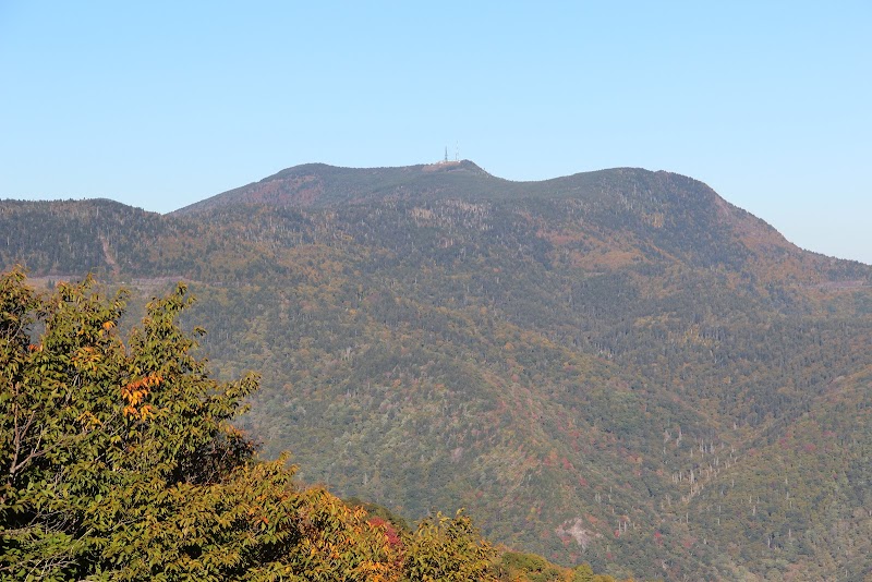
The Old Toll Road stretching from Black Mountain to Mount Mitchell is more than a mere pathway—it’s a journey through time etched into the rugged contours of North Carolina’s highest peaks. Originally built in the early 1900s, this historic route served miners, loggers, and early tourists as a critical conduit into the heart of the Blue Ridge, before modern roads took over. Designed as a toll road, it allowed access to what was then a remote wilderness, where nature pushed back with steep ascents and dense forest that seemed fiercely intent on remaining untamed.
Today, the remnants of this old road offer something more than just a hike—they provide a chance to engage directly with both history and nature’s raw forces. The trail itself covers approximately 6 miles of rugged terrain with an elevation gain near 3,000 feet, starting at the rolling foothills of Black Mountain and climbing relentlessly toward the summit of Mount Mitchell, the highest peak east of the Mississippi. Along the way, the forest presses in tight—tall firs and rhododendron hug the trail, their branches moving like restless guardians who dare you to go further.
Navigating this trail means facing rocky switchbacks and uneven footing, where every step demands your attention. The steep slopes push your endurance, but the payoff comes in spectacular views that suddenly open between the trees—glimpses of the surrounding Blue Ridge Mountains folding one into another beneath expansive skies. Each clearing offers a chance to pause and feel the mountain’s presence as a living, breathing force rather than a mere destination.
For those planning to follow these historic footsteps, preparation is key. The steep elevation means bringing plenty of water and wearing sturdy boots with solid traction to handle loose rock and occasional mud. Because weather on Mount Mitchell can change rapidly, layering clothing and starting early is vital to avoid afternoon storms that dare to turn the trail slick and dangerous.
The Old Toll Road tells stories from the past that weave into each traveler’s own adventure—the miners who once relied on it, the natural challenges it posed, and the unyielding spirit needed to traverse it. It invites not conquest, but respect and understanding of a landscape that remains fiercely itself, encouraging hikers to match its rhythm with steady effort and careful attention.
Embarking on this trail means stepping into a piece of history, feeling the pulse of the mountain, and walking a path that tests your resolve. It’s an experience built on the balance of challenge and reward, where every mile climbed uncovers a deeper connection to the wild heart of the Blue Ridge.
Nearby Trips
All Adventures
Boat Charters
Water Activities
Adventures near Black Mountain, North Carolina
Discover the unique and memorable adventures that make Black Mountain, North Carolina special.
Frequently Asked Questions
What is the total distance and elevation gain on the Old Toll Road trail?
The trail covers approximately 6 miles one-way with an elevation gain near 3,000 feet, climbing from Black Mountain to the summit of Mount Mitchell.
Is the trail suitable for beginners?
Due to its steep ascent and uneven terrain, the trail is best suited for hikers with moderate to advanced experience and a good fitness level.
Are there facilities or water sources along the way?
There are no reliable water sources on the trail, and limited facilities. Hikers should carry their own water and plan accordingly.
When is the best time to hike this trail?
Late spring through early fall offers more stable weather and better trail conditions, but early starts are recommended year-round to avoid afternoon storms.
Can cars access any part of the old toll road today?
Modern roads have replaced the Old Toll Road for vehicles, and the historical trail is now primarily a hiking route without motor access.
What historical significance does the Old Toll Road hold?
Built in the early 20th century, the toll road provided one of the first reliable access routes for miners, loggers, and early tourists seeking the higher elevations of Mount Mitchell.
Recommended Gear
Hiking Boots with Ankle Support
Provides stability and traction on rocky, uneven paths and protects ankles from twisting on steep sections.
Layered Clothing
Allows adaptation to changing temperatures and weather conditions, particularly important for summit winds and sudden storms.
Hydration System or Water Bottles
Maintains hydration; critical on steep climbs where exertion quickly leads to dehydration.
Trekking Poles
Helpful for balance on uneven terrain and reducing strain on knees during descents.
Local Insights
Hidden Gems
- "Small rock ledges along the trail offering intimate views of cascading streams usually missed by casual hikers."
- "A rarely visited spring near the midpoint that still flows clean and cold, ideal for refilling bottles."
Wildlife
- "Look for black bears cautiously moving through the forest understory, and listen for the sharp call of the pileated woodpecker high in the firs."
- "Eastern box turtles and salamanders inhabit the damp forest floor."
History
"The old toll road served as a vital artery for early 20th-century industries and tourism before paved roads were constructed. Toll fees funded its maintenance and were a testament to the effort required to access the mountain’s remote summit."