Top Scenic Backpacking Trails in the Sierra Nevada: Wilderness Lakes, Granite Domes, and High Mountain Passes
Explore the Sierra Nevada's top backpacking trails where wilderness lakes, granite domes, and high mountain passes combine for unforgettable adventure. This guide offers detailed trail info and practical tips to help you plan a trip that balances challenge with breathtaking scenery.
Hydration is Non-Negotiable
Alpine sections and granite ridges often lack water sources. Carry a reliable filter or purification method to stay hydrated throughout.
Footwear for Varied Terrain
Expect a mix of rocky slabs, forest trails, and loose scree. Choose sturdy, flexible boots or trail runners with good traction to handle this variety.
Start Early to Beat Weather
Afternoon thunderstorms are common in high passes July through September; aim to reach summits and exposed sections by midday.
Respect Wilderness Regulations
Permits are required for many Sierra backpacking routes. Secure all necessary permits early to avoid disruptions to your trip.
Top Scenic Backpacking Trails in the Sierra Nevada: Wilderness Lakes, Granite Domes, and High Mountain Passes
The Sierra Nevada stretches like a challenge daring you to explore its rugged edges and hidden sanctuaries. Among its granite giants and crystal-clear alpine lakes lie some of California's most breathtaking backpacking trails. Whether you seek forested switchbacks, expansive high passes, or windswept granite domes, these routes offer an unyielding blend of natural beauty and physical challenge.
1. The Rae Lakes Loop — Spanning roughly 41 miles with 5,800 feet of elevation gain, this trail winds through Kings Canyon National Park’s diverse ecosystems. You'll meet currents pushing forward at Rae Creek and glimpse shimmering lakes backing up to rolling granite domes. Expect dense lodgepole pine forests and open meadows where mountain goats roam with indifferent grace. Plan for 3 to 5 days, with campsites near water sources along the way.
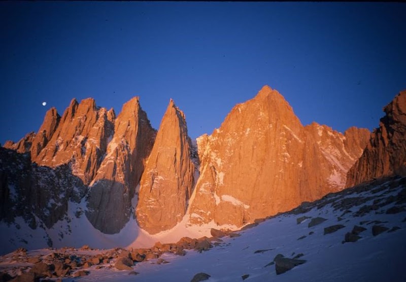
2. The John Muir Trail Segment: Yosemite to Mather Pass — Covering about 30 miles with significant climbs reaching over 12,000 feet, this segment threads through haunting high alpine terrain. The landscape shifts abruptly from shaded firs to exposed slick rock that demands confident footing. At Mather Pass, the world below suddenly feels distant as wind sculpts clouds around jagged peaks. It’s a route best tackled mid-summer when snowbanks have retreated.
3. The Desolation Wilderness: Lake Aloha Loop — Approximately 25 miles circling Lake Aloha, this trail highlights rugged granite domes and tranquil high lakes. The terrain is predominantly rocky and dry, requiring good navigation skills as trails can be narrow and faint. Water is scarce on certain stretches, so hydration planning is crucial. The area’s exposed ridges invite wind, making layering a non-negotiable.
Preparing for these trails demands respect for both wildlife and weather. Keep your pack light but well-stocked: water filtration systems, flexible footwear suitable for mixed terrain, and layered clothing to guard against alpine chills are essential. Start early to avoid afternoon thunderstorms, particularly from July to September.
The Sierra dialogues with those who listen. Rivers dare you to keep pace, granite summons patience, and high passes test endurance — all fiercely themselves. These backpacking paths invite you not to conquer but to engage, rewarding effort with searing views and quiet moments beside glacial waters. For adventurers ready to push limits and absorb wilderness on its terms, the Sierra's trails await and challenge in equal measure.
Nearby Trips
All Adventures
Boat Charters
Water Activities
Adventures near Bishop, California
Discover the unique and memorable adventures that make Bishop, California special.
Frequently Asked Questions
When is the best time to hike the Rae Lakes Loop to avoid crowds?
Late June to early July offers fewer hikers before the peak summer season, though some snow may remain. Mid-September is quieter but colder, with shorter daylight hours.
Are permits required for the John Muir Trail segment through Yosemite?
Yes, a wilderness permit is required for overnight trips on the John Muir Trail within Yosemite National Park. Permits must be reserved in advance, especially in summer months.
What wildlife might I encounter on these trails?
Expect to see mule deer, black bears, marmots, and occasionally mountain goats. Carry bear spray and store food properly to minimize wildlife encounters.
Can these trails be done year-round?
Generally no. Snowpack limits accessibility outside mid-summer to early fall. Winter trips require snow travel skills and equipment, and many trailheads are inaccessible in snow.
Are there lesser-known viewpoints worth seeking out on these trails?
Yes. Along the Rae Lakes Loop, the view from Glen Pass offers a less crowded, expansive perspective over multiple alpine lakes. Similarly, Estes Peak near Desolation Wilderness reveals a unique panorama away from main paths.
How should I prepare for river crossings in the Sierra Nevada?
Water levels can be deceptively strong, especially during snowmelt. Use trekking poles, unbuckle your backpack waist strap for quick release, and cross where water is calmest and shallowest.
Recommended Gear
Water Filtration System
Necessary to ensure safe drinking water from lakes and streams along the trail.
Layered Clothing
Vital for adjusting to temperature swings and chilly alpine conditions.
Sturdy Trail Boots
Supports feet across mixed terrain, including rocky granite and forest floors.
Lightweight Tent or Shelter
Provides protection from sudden weather changes and allows for overnight stays.
Local Insights
Hidden Gems
- "Glen Pass Overlook on Rae Lakes Loop"
- "Estes Peak around Desolation Wilderness"
- "Shadow Lake near Mather Pass route"
Wildlife
- "Mountain goats frequent granite ledges in Kings Canyon"
- "Black bears on forested trail sections"
- "Pikas scurrying among boulder fields in higher elevations"
History
"Many trails in the Sierra Sioux region follow routes used by Native American tribes such as the Mono and Paiute, as well as early 20th-century miners and conservationists who shaped access to these areas."