Trekking Through Time: Hiking the Aurès Mountains to the Roman Ruins of Timgad
Experience an unforgettable blend of natural beauty and ancient history hiking from the wild Aurès Mountains to the Roman ruins of Timgad near Batna. This trail offers a rewarding challenge for those ready to engage deeply with Algeria’s rugged landscapes and preserved past.
Start Early and Hydrate
Begin your hike at dawn to avoid the strongest sun and carry at least 2 liters of water per person to stay well hydrated on the dry mountain trail.
Wear Proper Footwear
Choose sturdy hiking boots with good grip to manage rocky and loose terrain safely.
Bring Offline Navigation
Mobile reception can be unreliable, so download offline maps or bring a GPS device for guidance along marked but remote trails.
Respect Fragile Ruins
Stay on designated paths within the archaeological site to protect ancient structures and avoid damage.
Trekking Through Time: Hiking the Aurès Mountains to the Roman Ruins of Timgad
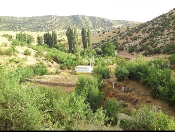
Set out early from Batna, where the Aurès Mountains rise with a rugged, unyielding presence, their slopes clothed in a mix of cedar and oak. The trail to Timgad spans roughly 12 kilometers one way, with an elevation gain of about 600 meters, demanding a steady pace through varied terrain—rocky switchbacks, shaded forest paths, and open ridges that offer wide, uninterrupted views of the Algerian plateau below. The mountains are not silent; the wind cuts sharp, pressing with intention against your back, while distant birds challenge your progress with sudden calls.
Along the way, the landscape challenges and rewards. Riverbeds dry or daring, depending on recent rains, sculpt the path’s urgency. Mid-hike, a sudden clearing allows your gaze to stretch far beyond, the ancient ruins of Timgad lying quietly beneath the sun, stone structures rising like echoes of a determined past. This Roman colonial city, founded in 100 AD, confronts you not just with history but with a lesson in longevity—its carefully laid streets and remnants of theaters, temples, and arches still standing fiercely after centuries.
Reaching Timgad after the hike feels earned, the ruins whisper their stories through cracked columns and the scattered remnants of mosaics. The practical side of exploring here includes carrying ample water—at least 2 liters per person—as the climate can turn quickly from cool mountain air to dry heat. Solid hiking boots with grip are a must: stones and loose dirt test your footing. The trail is well marked but cell service is spotty; offline maps or a GPS device are advisable.
Plan your trip for early morning starts to avoid midday heat, and wear layered clothing to respond to the temperature swings. Respect the environment: the Aurès Mountains are fiercely themselves and their wild ecosystem benefits from conscientious visitors. The archaeological site itself has areas fragile to foot traffic—stick to paths to preserve this remarkable piece of history.
This journey combines the wild force of nature with one of North Africa’s most impressive Roman relics—each step a measured engagement with the present and the past. It’s an adventure tuned to those who respect challenge, distance, and discovery in equal parts. Ultimately, the trail from the Aurès Mountains to Timgad offers more than a hike; it offers a mirror held up to endurance.
Nearby Trips
All Adventures
Boat Charters
Water Activities
Adventures near Batna
Discover the unique and memorable adventures that make Batna special.
Frequently Asked Questions
How difficult is the hike from Aurès Mountains to Timgad?
This hike is considered moderate. It covers about 12 km one way with roughly 600 meters elevation gain. The terrain is varied, including rocky paths and forested sections, requiring solid fitness and sure-footedness.
What should I bring for the hike?
Bring sturdy hiking boots, layered clothing, at least 2 liters of water per person, sun protection, and a navigation device or offline maps due to spotty cell service.
Is the site of Timgad easy to explore once I arrive?
Yes, Timgad is accessible with marked paths through the ruins. However, to protect the site, visitors should stay on designated walkways and respect any restricted areas.
When is the best time to hike this trail?
Early spring and fall provide the best combination of mild weather and scenic views. Summer afternoons can be too hot, and winter mornings may start cold but are generally manageable.
Are there guides available for this hike?
While the trail is marked, hiring a local guide can enrich the experience by providing historical context and ensuring safety especially for first-time visitors unfamiliar with the terrain.
Can I camp near the ruins or on the trail?
Camping is not officially permitted at the archaeological site of Timgad. On the trail, dispersed camping is possible but should be done responsibly and away from sensitive natural and historical areas.
Recommended Gear
Hiking boots
Protects feet and ankles on rocky, uneven surfaces, providing necessary grip.
Water reservoir or bottles
Staying hydrated is critical, especially under intense sun and dry mountain air.
Layered clothing
Allows you to adapt to temperature swings from chilly mornings to warmer afternoons.
Portable GPS or offline map
Reliable navigation backup for trails with unreliable mobile coverage.
Local Insights
Hidden Gems
- "The viewpoint at Oued el Abiod river valley near halfway point offers a quieter perspective with a dramatic natural setting."
- "Small, lesser-known mosaics tucked in shaded corners of Timgad’s residential quarters reveal intimate details of Roman daily life."
Wildlife
- "Keep an eye out for the endangered Barbary macaque in higher forested areas and birds of prey circling above cliffs."
- "Springtime brings bursts of colorful butterflies and humming insects that animate the mountain air."
History
"Timgad was established as a Roman military colony and designed with precise grid layouts. Its ruins reflect Roman urban planning in North Africa and hold importance both architecturally and culturally as evidence of Roman influence in the region."