Backpacking the Loyalsock Trail: Ridges, Streams, and Endless Solitude in Pennsylvania
The Loyalsock Trail offers backpackers an immersive route through rugged ridges, babbling streams, and deep solitude in northern Pennsylvania. This guide provides the essential details and tips to plan a rewarding trek through one of the state’s most overlooked wilderness paths.
Footwear Matters
Choose boots or trail shoes with strong ankle support and excellent traction to handle steep ascents and slippery rocks along the route.
Water Filtration Is Key
Though streams are abundant, treat all water before drinking to avoid common pathogens in backcountry sources.
Start Early Each Day
Begin hiking at dawn to tackle elevation gains in cooler temperatures and secure daylight for navigation in remote areas.
Pack for Variable Weather
Prepare for fast-changing conditions with moisture-wicking layers and rain gear, especially during spring and fall months.
Backpacking the Loyalsock Trail: Ridges, Streams, and Endless Solitude in Pennsylvania
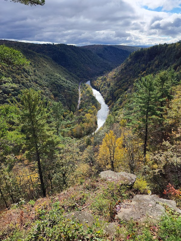
The Loyalsock Trail stretches nearly 59 miles through Pennsylvania’s northern wilds, a rugged path that challenges backpackers with its mix of steep ridges, rushing streams, and dense forests. From the moment you step onto the trail, the environment asserts itself — rock outcrops lean over narrow paths, creeks chatter alongside, daring you to keep pace. Elevation changes are frequent and sharp, with total gains pushing around 8,500 feet, demanding steady footing and a prepared mindset.
Expect a route shaped by the Allegheny Plateau that swings you across and along ridges, where panoramic views open suddenly, rewarding every laborious climb. The forest here is a company of tall hardwoods — oaks and maples whose leaves can sparkle like emeralds or blaze with fall’s fire depending on your timing. Streams punctuate the trek, their currents pushing forward relentlessly, inviting well-deserved breaks for hydration and reflection.
Packing smart means preparing for both heat and moisture. Sturdy, well-broken-in footwear with solid ankle support is key; sections of loose rock and wet roots demand sure steps. Water sources are frequent but not always crystal clear, so a reliable filtering system is a must for safety. And while the trail may feel remote, cell service appears sporadically — leave detailed plans with someone and carry navigation tools.
Start early to maximize daylight on the toughest climbs. Spring and fall offer cooler temps and fewer bugs, enhancing comfort and solitude. Summer’s warmth brings more active wildlife but also heat and thunderstorms, which the exposed ridges invite with little shelter. Winter requires experience beyond the average but delivers stark beauty and silent woods. Know the seasons, respect the trail’s demands, and enjoy the rare pleasure of moving through a trail fiercely itself.
The Loyalsock Trail doesn’t just test your physical limits; it invites a dialogue with nature. Each ridge, stream, and shadowed hollow feels alive — challenging your pace, your judgment, and your will to keep moving forward into solitude that refreshes and humbles. Prepare well, tread carefully, and you’ll carry home stories etched in the rhythm of the forest and the flowing wildness that refuses to be tamed.
Nearby Trips
All Adventures
Boat Charters
Water Activities
Adventures near Wellsboro, Pennsylvania
Discover the unique and memorable adventures that make Wellsboro, Pennsylvania special.
Frequently Asked Questions
Is the Loyalsock Trail well-marked?
Yes, the trail is marked with yellow blazes that are generally easy to follow, though map and compass or GPS are recommended due to occasional confusing junctions.
Are campsites available along the trail?
Designated campsites and established shelter areas are limited. Many hikers use dispersed camping near water sources, following Leave No Trace principles.
Can I hike sections of the trail as day trips?
Absolutely. Several access points allow for shorter day hikes ranging from a few miles to longer loop options, ideal for partial exploration.
What wildlife might I encounter?
Expect to see white-tailed deer, black bears, various songbirds, and occasionally wild turkeys. Carry bear spray and store food properly.
How difficult are the elevation changes?
The trail features frequent steep climbs and descents, with a total elevation gain around 8,500 feet, requiring solid fitness and careful pacing.
Is the trail accessible year-round?
Yes, but winter conditions can be severe. Spring mud and summer heat also pose challenges. Fall is often preferred for balance of conditions.
Recommended Gear
Water Filter or Purification Tablets
Consistent access to clean water requires filtering from streams to avoid illness.
Sturdy Hiking Boots
Essential for protecting feet and ankles on rocky, uneven trails with elevation shifts.
Layered Clothing System
Allows adjustment to temperature swings and weather changes common on the trail.
Rain Gear
Protects from sudden showers and storms typical in the region.
Local Insights
Hidden Gems
- "The High Knob lookout offers a less-visited panoramic view west of the trail’s main ridgeline."
- "Hidden waterfalls along Loyalsock Creek, such as Angel Falls, can be accessed with short side trails."
- "The rocky outcrop at T-Swamp provides unique terrain and quiet solitude away from the main path."
Wildlife
- "Black bears, especially in spring and early summer when food is scarce."
- "Ruffed grouse thrive in the mixed forest habitats along the trail."
- "Eastern hellbender salamanders inhabit some creek sections but are elusive."
History
"The trail follows routes used by Native American paths and early settlers, with some sections near remnants of logging railroads from the late 19th century."