Best Scenic Backpacking Routes in the Great Smoky Mountains Near Pisgah National Forest
Experience the rugged beauty of the Great Smoky Mountains near Pisgah National Forest through scenic backpacking routes that blend vivid landscapes with practical challenge. From waterfall loops to ridge-top trails, discover paths that invite all skill levels to engage with this fiercely alive wilderness.
Pack Layers for Variable Weather
Temperatures on these routes can swing dramatically with elevation and time of day; include moisture-wicking layers and a waterproof shell.
Treat All Water from Streams
Though many creeks run clear, always purify water using filters or chemical treatments to avoid waterborne illnesses.
Footwear With Good Traction
Expect wet rocks and uneven terrain—sturdy hiking boots with solid grip will reduce slip risk and ankle injuries.
Start Early to Avoid Afternoon Storms
Mountain weather shifts fast; begin hikes early to maximize daylight and avoid exposure to sudden summer storms.
Best Scenic Backpacking Routes in the Great Smoky Mountains Near Pisgah National Forest
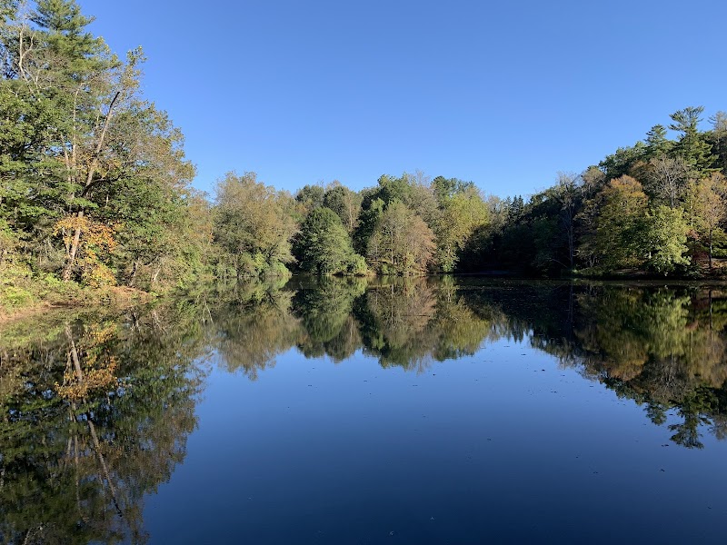
The Great Smoky Mountains rise with a raw energy just south of Pisgah National Forest, offering backpacking routes that both challenge and reward with vivid forest trails, rushing rivers, and panoramic mountain views. Whether you're starting from the Pisgah boundary or dipping deep into its neighboring ridges, these routes invite hikers to engage closely with terrain that is fiercely itself. Expect paths that twist through rhododendron thickets, cross creeks daring you to stay dry, and ascend to overlooks commanding great sweeping vistas.
One prime route is the Appalachian Trail segment from Clingmans Dome down to Newfound Gap. It stretches just under 10 miles with an elevation drop of about 2,000 feet, making it moderately challenging. The rocky footing demands solid boots but rewards with ridges where clouds drift like living curtains and spruce trees reach heavenward. Hydration is critical here — streams are plentiful but always treat water before drinking.
Another notable journey is the Deep Creek Loop, at about 6 miles, with moderate elevation gain and a terrain mixing gravel beds, forest floor, and occasional rocky steps. The loop captures cascading waterfalls that roar with personality and hardwood forests that shift their clothing throughout the seasons. Campsites along the trail provide practical rest points for multi-day backpackers.
For those leaning into a tougher adventure, the route from Mount LeConte to Alum Cave Bluffs spans roughly 8 miles with steep climbs and uneven footing, totaling about 2,600 feet elevation gain. This trail tests stamina and sure-footedness but opens onto bluffs where the wind pushes like a presence, and the views stretch across mountain ridges like a living map.
Preparation means packing layered clothing to adjust as temperatures at higher altitudes can swing swiftly. A durable backpack with hydration ensures comfort on longer treks. Start early to avoid afternoon storms common in summer and watch the sky closely as weather can change fiercely fast. Whether you’re chasing autumn colors or summer’s green canopy, these routes deliver raw mountain spirit balanced by accessible wilderness infrastructure.
With careful planning, respect for the environment, and solid gear, your backpacking trips here can turn into memorable encounters with a wild landscape that feels alive—one to listen to, to pace with, and to navigate thoughtfully. The Great Smokies near Pisgah are not about conquering nature, but learning its rhythm and responding with skill and care.
Nearby Trips
All Adventures
Boat Charters
Water Activities
Adventures near Waynesville, North Carolina
Discover the unique and memorable adventures that make Waynesville, North Carolina special.
Frequently Asked Questions
Are permits required for backpacking in these trails?
No permits are required for day hiking or overnight backpacking in most areas near Pisgah and the Great Smoky Mountains; however, camping in designated sites only is mandatory to protect natural resources.
What wildlife should I be prepared to encounter?
Hikers may see white-tailed deer, black bears (keep food secured), salamanders, and a variety of bird species like the ruffed grouse or warblers. Staying alert and making noise reduces unwanted close encounters.
Are the trailheads accessible for beginners?
Most trailheads are accessible via paved roads and provide parking, but trail difficulty ranges. Beginners should opt for routes like Deep Creek Loop before advancing to steeper climbs.
What should I know about environmental stewardship here?
Practice Leave No Trace principles: pack out all trash, avoid picking plants, stay on established trails to reduce erosion, and camp only in designated areas.
Where can I find lesser-known viewpoints on these routes?
Along the Appalachian Trail segment near Clingmans Dome, a spur trail leads to Andrews Bald, offering quieter panoramas with fewer visitors. Additionally, Alum Cave Bluffs have hidden niches less frequented but spectacular at dawn.
Is cell service reliable in these trails?
Cell reception is spotty to nonexistent on many parts of the trails. Preparation should include offline maps and informing someone of your itinerary before heading out.
Recommended Gear
Hiking Boots with Ankle Support
Provides stability and traction on the rocky, uneven trails common in this area.
Water Filter or Purification Tablets
Necessary for safe hydration from streams along the route.
Layered Clothing System
Allows for quick adaptation as temperature and weather conditions shift throughout the day.
Trekking Poles
Helpful for balance on steep climbs and creek crossings but optional based on personal preference.
Local Insights
Hidden Gems
- "Andrews Bald's quiet overlook"
- "The secluded spray of Tom Branch Falls"
- "Hidden alcoves near Alum Cave Bluffs"
Wildlife
- "Black bears"
- "Eastern box turtles"
- "Southern flying squirrels"
- "Ruffed grouse"
History
"This region holds Cherokee heritage and early settler history, with preserved cabins and old logging remnants along certain trails."