Backpacking New Mexico’s Wild Continental Divide Trail: An Adventure of Rugged Beauty and Raw Challenge
The Continental Divide Trail through New Mexico reveals raw wilderness and rugged terrain that challenge hikers of all levels. Combining high mountain passes, dense forests, and desert expanses, this stretch offers profound solitude and stunning vistas for those prepared to answer its call.
Plan for Hydration Gaps
Water sources vary widely along New Mexico’s section of the CDT. Carry a reliable water filter and plan resupplies carefully, as some stretches have minimal or seasonal water availability.
Prepare for Rapid Weather Shifts
Mountain weather can change abruptly, especially in summer with afternoon thunderstorms or sudden cold snaps in fall. Pack versatile layers and waterproof gear to stay safe.
Use Detailed Navigation Tools
Trail markings are inconsistent. Bring a GPS device or multiple detailed maps and have a backup navigation method to avoid losing the trail in dense forest or rugged terrain.
Choose Footwear for Rocky Terrain
The trail alternates between soft forest floors and rock-strewn ridges. Shoes or boots with firm ankle support and durable soles will reduce injury risk and improve comfort.
Backpacking New Mexico’s Wild Continental Divide Trail: An Adventure of Rugged Beauty and Raw Challenge
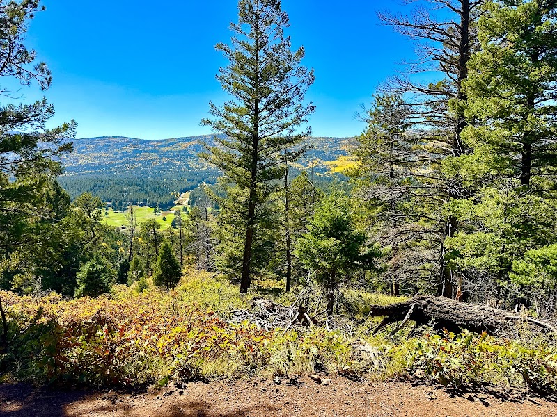
Stretching roughly 340 miles across New Mexico, the Continental Divide Trail (CDT) carves a fierce and independent path through some of the Southwest’s most untamed landscapes. Here, the trail is no polite stroll; it demands respect as it climbs and drops amid sweeping mesas, thick forests, and the jagged spine of the Sangre de Cristo Mountains. Hikers are drawn not just by distance, but by the trail’s personality — rivers daring you to cross, winds pushing forward with unyielding insistence, and landscapes fiercely themselves.
Starting near the southern border, the CDT quickly introduces you to the Challenge of elevation gain, often fluctuating between 7,000 and 12,000 feet. Sections near the San Juan Mountains test endurance with rugged terrain — rocky switchbacks and exposed ridgelines that sharpen alertness and pack weight management. Yet the trail never withholds rewards: panoramic overlooks stretch across desert basins and distant peaks, where sky and earth seem to stretch limitlessly.
Walk through ponderosa pine forests where sunlight sifts softly through branches, and the scent of piñon and juniper marks the air with an earthy signature. Streams weave boldly across the path—sometimes shallow and inviting, other times rushing with unexpected force, testing your river-crossing skills.
Timing is key. Spring snowmelt brings swollen creeks and slippery rocks; summer offers long days and dry heat but invites afternoon thunderstorms that demand quick shelter and caution. Fall chills the air and colors the trees, a quieter time that showcases wildlife ranging from mule deer to elusive black bears — but watch for early snow near the high passes.
Preparing for the CDT in New Mexico requires solid gear choices and navigation readiness. Footwear must balance sturdiness and breathability to handle rocky trails and sandy stretches. Hydration strategies include reliable water filtration, as natural sources can be scarce or seasonally unreliable. Carry adequate maps or GPS, as signage is sparse and the wilderness often presses back with uncompromising silence.
For those embracing both the physical challenge and the quiet grandeur, the CDT in New Mexico offers a journey of engagement. It’s a chance to test your limits, to respond to the land’s fierce rhythms, and to emerge with a deeper understanding of what wild means here — not a place to conquer, but one to move through with respect and presence.
Nearby Trips
All Adventures
Boat Charters
Water Activities
Adventures near Taos, New Mexico
Discover the unique and memorable adventures that make Taos, New Mexico special.
Frequently Asked Questions
How difficult is the New Mexico section compared to others on the CDT?
New Mexico’s section is generally considered challenging due to elevation gains, rugged terrain, and variable weather. It is less technical than some northern stretches but requires strong endurance and reliable navigation.
When is the best time to hike this section?
Late spring through early fall is ideal, with June to September offering the best balance of accessible trails and manageable weather. Early spring and late fall can be cold and unpredictable, while winter is mostly unsuitable for standard backpacking.
Are there resupply points along the New Mexico CDT?
Yes, towns like Taos and Questa offer good resupply options, but some sections between towns cover long distances without services. Planning food caches and delivery ahead of time is essential.
What wildlife should I expect to encounter?
Mule deer, elk, black bears, and various small mammals inhabit these forests. Rattlesnakes are also present, primarily in lower, warmer areas. Always maintain a safe distance and store food properly.
How accessible is the trailhead for New Mexico’s CDT section?
The southern trailhead near the border is remote but reachable via dirt roads from nearby towns. Taos serves as the primary gateway for many hikers due to its amenities and proximity.
Is the trail well-marked in New Mexico?
Markings are inconsistent. While some areas have clear blazes, many stretches require strong navigational skills and preparation to follow the route safely.
Recommended Gear
Lightweight Hiking Boots with Ankle Support
Durable and comfortable boots that protect your feet on rocky terrain and provide stability on uneven ground are vital for the New Mexico CDT’s varied landscapes.
Water Filtration System
A sturdy filter or purifier ensures access to safe drinking water where natural supplies can be scarce or contaminated.
Layered Clothing System
Insulating and moisture-wicking layers help manage temperature swings between sun-exposed ridges and chilly mountain nights.
Reliable GPS and Paper Maps
With sparse trail markings, dependable navigation tools can prevent getting lost in dense forest or remote ridgelines.
Local Insights
Hidden Gems
- "The Ghost Ranch area offers red rock formations and fossil sites just off the trail."
- "The remote Wheeler Peak Wilderness contains lesser-known high-alpine meadows and quiet, less-traveled ridgelines."
Wildlife
- "Keep watch for the elusive New Mexico jumping mouse in riparian zones."
- "Golden eagles soar above the high plateaus, offering dramatic wildlife watching from ridges."
History
"This trail crosses lands rich with Native American history, including sacred sites of the Taos Pueblo people and historic trading routes once critical to early settlers and indigenous groups."