Hidden Mountain Vistas and Secluded Waterfalls in Nantahala National Forest
Discover the less-traveled mountain trails and secret waterfalls of Nantahala National Forest. This guide unwraps practical route details and sensory highlights for an adventurous yet accessible wilderness experience.
Start Early to Avoid Midday Heat
Mountain temperatures can soar by midday, especially on exposed ridges. Begin your hikes early for cooler air and minimal crowds.
Wear Footwear with Good Traction
Trails include rocky and slippery sections near waterfalls and ledges—hiking boots with solid grip minimize slips and injuries.
Pack Sufficient Water and Snacks
Hydration is crucial on moderately strenuous hikes and during summer months. Bring enough water and energy-rich snacks for the entire journey.
Respect Wildlife and Stay on Trail
Avoid disturbing local wildlife and prevent trail erosion by sticking to established paths and observing animals from a distance.
Hidden Mountain Vistas and Secluded Waterfalls in Nantahala National Forest
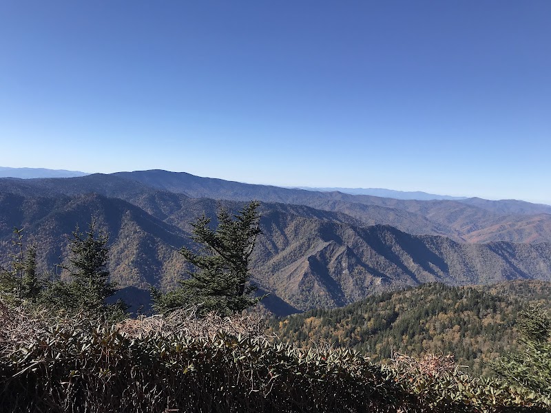
Nantahala National Forest stretches across more than half a million acres of western North Carolina, offering an underrated wilderness packed with rugged mountain views and quietly flowing waterfalls that refuse to crowd the beaten path. For hikers looking to engage with nature on their own terms, this forest sends a clear invite to explore its less frequented terrain where the mountains still hold their untamed rhythms.
Start with the Waterrock Knob Ridge Trail, a 3.2-mile loop with a steady 700-foot elevation gain that climbs through dense pine and hardwood stands. The trail’s quiet slopes open periodically to sharp, expansive views over the Blue Ridge’s undulating ridges. The air here pushes cool and crisp, flowing past you like a reminder of the wildness in these elevations. You’ll want sturdy hiking boots for the sometimes rocky footing, and a good hydration plan—the climb demands steady energy.
Next, head towards Juney Whank Falls. This hidden waterfall sits off the Juney Whank Falls Trail, a 1.8-mile out-and-back route beneath a cathedral of mixed forest. The descent is steep but manageable, with roots and stones acting as natural steps, and the sound of water daring your steps forward. The waterfall itself is a quiet cascade, plunging 45 feet into a shaded pool that invites a refreshing pause. Prepare for slick rocks near the falls; waterproof footwear with good traction is a must.
For a longer journey, consider the Tanawha Trail segment near Rough Ridge. Stretching about 4.5 miles round trip with a 900-foot elevation gain, this route reveals rocky balds and ledges that command expansive views over grand valleys and forest crowns. The terrain varies from packed dirt to rugged rock scrambles—practical gear and some scrambling experience will ensure safety and enjoyment.
Planning your trip? The best times to visit are spring through early fall when the forest edges awake with vibrant life and well-maintained trails. Early mornings offer the quietest conditions and most refreshing air, while late afternoon light sharpens the contours of distant peaks for photographers.
Water, footwear, and layered clothing are your essentials here. Trails can be deceiving; each bend and crest tests both resolve and respect for the mountains, which remain fiercely themselves—unpredictable and commanding. The Nantahala’s off-trail attractions offer both the thrill of discovery and grounded beauty, rewarding those prepared to meet its pace and moods with rare mountain moments and waterfall whispers that stay with you long after the hike ends.
Nearby Trips
All Adventures
Boat Charters
Water Activities
Adventures near Sylva, North Carolina
Discover the unique and memorable adventures that make Sylva, North Carolina special.
Frequently Asked Questions
Are these trails suitable for beginners?
Most trails discussed are moderate with manageable elevation gains, suitable for hikers with basic fitness and some trail experience. Beginners should prepare for uneven terrain and consider shorter routes like Juney Whank Falls.
What wildlife might I encounter?
Expect to see white-tailed deer, black bears (seen mainly at dawn or dusk), various songbirds, and possibly salamanders near streams and waterfalls.
Is there cell service within the forest?
Cell coverage is spotty and unreliable in many parts of Nantahala, especially along ridge trails and deep valleys, so prepare for limited connectivity.
What permits or fees are required?
Nantahala National Forest does not require a permit for day hiking. However, some trailheads may have parking fees or require adherence to local regulations.
Are dogs allowed on these trails?
Dogs are permitted but must be kept on leash due to wildlife and terrain hazards. Bring water for your pet and be mindful of ticks and insects.
What is the best way to reach trailheads?
Most trailheads are accessible via well-maintained forest service roads off US-74 near Sylva. High-clearance vehicles are recommended for rougher forest roads.
Recommended Gear
Hiking boots with ankle support
Protect your feet on rocky and root-filled trails with sturdy boots offering grip and stability.
Water reservoir or hydration bottles
Stay hydrated on long hikes; the forest canopy limits natural water sources and sunlight can raise body temperatures quickly.
Layered clothing
Temperatures fluctuate; breathable base layers combined with insulation and a waterproof jacket prepare you for changing conditions.
Trekking poles
Useful for balance during steep descents and rocky paths near waterfalls or ridge scrambles.
Local Insights
Hidden Gems
- "The small ledge viewing area east of Waterrock Knob Trail that few visitors find"
- "A moss-covered rock outcrop near the Juney Whank Falls base offering quiet birdwatching"
Wildlife
- "Pine marten sightings are rare but possible in remote areas"
- "Eastern box turtles frequent moist trail edges in late summer"
History
"Nantahala National Forest was established in the early 20th century and has ties to Appalachian logging history and early conservation efforts. Many trails follow paths once used by timber crews and local communities."