Trailblazing Through Routt: Navigating Clark’s Vast Footpaths in Routt National Forest
Routt National Forest in Clark, Colorado, offers extensive trails that challenge and reward hikers with shifting terrains and vibrant forest scenes. Whether you’re tinting your boots on shorter creek-side loops or tackling ridge-top routes, this destination demands respect and delivers panoramic views.
Hydrate Early and Often
The dry mountain air and steady ascent raise dehydration risks quickly. Start well-hydrated and refill often at creek crossings when safe.
Layer for Variable Weather
Temperatures shift drastically between shaded forest and exposed ridges; quick weather changes like afternoon storms are common.
Footwear with Good Traction
Rocky and root-laced trails call for sturdy boots with solid ankle support and reliable soles for uneven terrain.
Early Start Recommended
Begin hikes before 9 a.m. to avoid afternoon thunderstorm buildup typical in summer months.
Trailblazing Through Routt: Navigating Clark’s Vast Footpaths in Routt National Forest
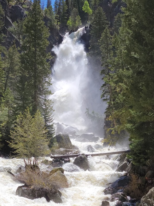
Routt National Forest near Clark, Colorado, challenges the adventurous spirit with an expansive network of trails designed for every level of hiker. The landscape shifts rapidly — from dense stands of spruce and fir that whisper underfoot, to open ridges offering vistas where the horizon dares you forward. Trails vary in length from short 3-mile loops to strenuous 15-mile routes, with elevation gains ranging up to 2,500 feet, demanding steady pacing and respect for the forest’s rugged character.
Among the best-known paths, the Buffalo Pass Trail climbs steadily for 7 miles, threading through wildflower-packed meadows before dropping to crystal-clear alpine streams that seem to push you onward. The terrain here mixes soft dirt paths with rocky patches, requiring sturdy footwear equipped for varied footing.
Those seeking a less crowded route can explore the Little Beaver Creek Trail, a gentler 4.5-mile trek with a modest 700-foot ascent. The trail keeps close to creek beds where the water murmurs its challenge amid the towering pines, offering a sense of calm purpose under the forest canopy.
Plan mid-morning to early afternoon excursions to avoid afternoon thunderstorms, which frequently push through during summer. Hydration is critical—carry at least two liters per person—and layering is wise, with temperatures swinging rapidly as elevations shift. Trailhead maps are available at the Forest Service office in Clark, and cell service is spotty, so offline maps or GPS devices come highly recommended.
This collection of trails is fiercely itself: uncompromising and alive. The forest doesn’t give itself over immediately but asks for patient attention. It rewards with open ridges offering panoramic views of the Park Range and the tantalizing promise of more trails beyond the next ridge. Prepare to meet the forest on its terms, respect its rhythms, and gain a foothold on a genuine Colorado adventure.
Nearby Trips
All Adventures
Boat Charters
Water Activities
Adventures near Steamboat Springs, Colorado
Discover the unique and memorable adventures that make Steamboat Springs, Colorado special.
Frequently Asked Questions
Are dogs allowed on Routt National Forest trails?
Yes, dogs are welcome but must be kept on a leash to protect local wildlife and other visitors. Make sure to bring waste bags and water for your pet.
Is it necessary to have a permit for hiking in Routt National Forest?
Most day hiking does not require a permit, but specific areas or activities such as camping or group events might. Always check current Forest Service regulations before your trip.
What wildlife might I encounter on the trails?
Expect to see mule deer, elk, and occasionally black bears or mountain lions. Early morning and evening hikes improve chances of spotting animals while reducing surprise encounters.
Can I bring mountain bikes on these trails?
Some trails allow mountain biking, but many are hiking-only to protect sensitive terrain. Verify trail designations to avoid restricted areas.
How do I prepare for sudden weather changes?
Layer clothing, carry rain gear, and start early to avoid afternoon storms. Always check local forecasts before heading out.
What should I do in case of an emergency in the forest?
Carry a whistle and a fully charged phone with offline maps. Know the nearest landmarks and trailheads, and if possible, hike with a companion to ensure help is available.
Recommended Gear
Sturdy Hiking Boots
Provides traction and ankle support essential for rocky and uneven trail conditions.
Hydration System (Water Bottles or Bladder)
Necessary to maintain hydration due to dry mountain air and exertion.
Layered Clothing
Allows adjustment to temperature changes and sudden weather shifts.
Offline GPS or Physical Map
Cell service can be unreliable; navigation tools are needed to stay on track.
Local Insights
Hidden Gems
- "Lookout Rock, a low-profile outcrop offering a peaceful vantage on the western forest edge."
- "Hidden Lake Trail’s untouched marshes attract rare bird species in spring."
Wildlife
- "Keep an eye on early black bear activity along riparian corridors during spring and fall."
- "Watch for American marten darting through dense underbrush in the quieter trail sections."
History
"The area preserves traces of Ute Native American use and mining history, with old cabins and rusted equipment visible along some less-traveled paths."