Explore Idaho’s Alpine Triangle, a demanding yet rewarding backcountry route linking Stanley, Challis, and Salmon. This guide equips adventurers with the practical knowledge and vivid details to prepare for a journey through rugged terrain, wild rivers, and expansive mountain views.
Hydrate with Reliable Water Sources
Carry a high-quality filter to safely use river water. The fast-flowing Salmon River and tributaries are plentiful but require purification.
Footwear for Mixed Terrain
Choose sturdy boots with good traction to navigate rocky ridges and soft forest floors. Waterproof options are helpful for river crossings.
Start Early to Maximize Daylight
Plan your hiking days from early morning to avoid afternoon storms and fully enjoy views during softer light periods.
Respect Wildlife and Maintain Distance
Expect encounters with deer, elk, and occasionally bears. Keep food sealed and remain calm to avoid startling animals.
Idaho's Alpine Triangle: The Ultimate Backcountry Route Through Stanley, Challis & Salmon
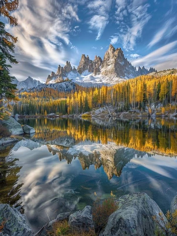
The Alpine Triangle in Idaho offers a rugged backcountry experience connecting three mountain towns—Stanley, Challis, and Salmon. This roughly 90-mile loop pits you against wild rivers, steep alpine meadows, dense forests, and limestone escarpments, with each segment daring you to engage with landscapes fiercely themselves. You'll start in Stanley, elevation 6,250 feet, where the Salmon River whispers through narrow canyons, before pushing east toward Challis. Expect to climb and descend around 7,500 feet total elevation gain over uneven terrain—rocky stretches that test your footing and shaded trails that carry the scent of pine and fir.
The route’s pace is dictated by the land around you: sudden bursts through open ridges offer sweeping views of the Sawtooth Range, while thick woods envelop you in quiet shadows, broken only by distant bird calls. Salmon’s wide river channels invite a pause, challenging you to measure your energy against the current’s rhythm.
Prepare for varied weather—warm days can shift to cool nights quickly. Hydration is crucial; rivers are plentiful but often swift, so a reliable water filter is a must. Footwear should grip on slick rock and soft dirt alike, and be ready for stretch of slog that make trekking poles more friend than extra weight. The best months for this trek are July through September when snow has melted and trails are most accessible.
With a balance of challenge and reward, the Alpine Triangle isn’t a trail to conquer but a route to engage with. Its character comes from how it shifts beneath your steps and the wildness pressing close. Respect the pace it demands, plan carefully, and it will reveal views and moments that stay with you long after your boots are rested.
Nearby Trips
All Adventures
Boat Charters
Water Activities
Adventures near Stanley, Idaho
Discover the unique and memorable adventures that make Stanley, Idaho special.
Frequently Asked Questions
What permits are required for hiking the Alpine Triangle?
No special backcountry permits are generally required to hike the Alpine Triangle, but visitors should check with the Boise National Forest and local ranger stations for any seasonal restrictions or fire regulations.
Is the route well-marked or will I need navigation skills?
The trail segments vary in marking; some parts are well-traveled while others require competent navigation with maps, GPS, or a reliable app as signs can be sparse.
Where is the best place to resupply or rest during the route?
Stanley is the prime hub with stores and amenities. Challis and Salmon offer smaller resupply points, but options are limited, so plan accordingly.
Are there any river crossings I should be concerned about?
Yes, certain sections involve fording parts of the Salmon River and tributaries; water levels can vary. Check conditions before hiking and bring appropriate gear to stay safe.
Can I camp anywhere along the route?
Dispersed camping is allowed in most areas, but some designated wilderness zones have specific rules. Always camp on durable surfaces and follow Leave No Trace principles.
What wildlife might I encounter on this trail?
Expect to see elk, mule deer, black bears, and a variety of bird species such as peregrine falcons and pine grosbeaks. Maintain respectful distance and secure food.
Recommended Gear
Water filtration system
Allows safe consumption from natural water sources encountered frequently on the route.
Hiking boots with ankle support
Provides stability on rugged trails that alternate between rocky and soft terrain.
Lightweight rain jacket
Protects against afternoon thunderstorms and variable mountain weather.
Trekking poles
Helps reduce joint strain on uneven ground and assists with river crossings.
Local Insights
Hidden Gems
- "Frenchman’s Bend Viewpoint offers a less-visited overlook of the Salmon River cutting through granite cliffs."
- "The hot springs near Sunbeam allow soothing soak after several days on the trail."
Wildlife
- "Mountain goats inhabit upper alpine ridges, often visible from clearings in late summer."
- "The rare wolverine has been spotted in the backcountry; sightings are extremely uncommon but not impossible."
History
"This route traces historical pathways used by Native American tribes and early explorers. The area holds significance for Shoshone and Bannock people as seasonal hunting and fishing lands."