Top Backpacking Trails in Utah’s Zion National Park: Canyon Adventures and Pine Forest Retreats
Zion National Park offers backpackers a unique blend of rugged canyon corridors and tranquil pine forests. This guide highlights the top trails, providing precise details and essential tips to help you navigate Zion’s diverse terrain confidently and safely.
Stay Hydrated and Carry Extra Water
Many Zion trails have limited water access or dry stretches. Bring at least 3 liters per day, and consider a water filter if you plan longer routes near streams.
Wear Supportive, Waterproof Footwear
Streams and wet crossings are common on Zion’s canyon trails. Comfortable, waterproof hiking shoes improve safety and comfort during those wet sections.
Start Early to Avoid Heat and Crowds
The desert sun intensifies by mid-morning. Starting at dawn reduces heat stress and allows more time for slower, cautious hiking in technical areas.
Reserve Permits in Advance
Certain routes like The Subway require permits to limit visitor impact. Book permits months ahead to secure your spot for peak seasons.
Top Backpacking Trails in Utah’s Zion National Park: Canyon Adventures and Pine Forest Retreats
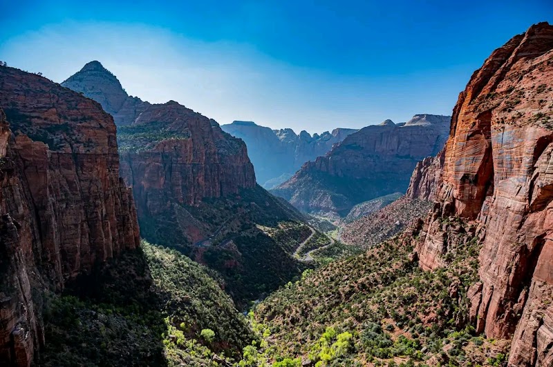
Zion National Park’s terrain shifts swiftly—towering sandstone cliffs give way to cool pine forests, each trail a distinct chapter in a story of raw, natural force. For backpackers craving variety, this is a ground where canyons dare you forward, and pine-scented trails invite measured steps. Below are the top trails to experience both aspects of Zion’s landscape, paired with practical insights to prepare for your journey.
1. The Subway (Left Fork of North Creek Loop) Distance: 9 miles round trip | Elevation Gain: ~1,200 ft | Terrain: Slot canyon, river crossings, scrambling
The Subway is a technical marvel of Zion—a narrow slot canyon carved with precision. Water dares you to keep pace as you wade, jump, and clamber through shimmering pools and slick rock. It’s a challenging route requiring a permit and some route-finding skill. Early spring or fall is ideal; summer heat combined with water currents can be tough.
2. West Rim Trail Distance: 16 miles point-to-point | Elevation Gain: 2,400 ft | Terrain: Mixed terrain, exposed ridges, forested sections
For those wanting big views with a balanced challenge, the West Rim Trail pushes high above Zion Canyon before threading into quiet pine forests. The elevation gain is steady, and the trail opens to panoramic overlooks that demand a pause to breathe and take in the raw cliffs and distant plateaus. Water is scarce here—carry ample supplies.
3. La Verkin Creek Trail Distance: 13.5 miles one way | Elevation Gain: 1,200 ft descent mostly | Terrain: Riverside, shaded woods, moderate stream crossings
La Verkin Creek winds through thick green pockets where the forest cools the air. The creek guides you gently, its voice steady against the brush and rocks, offering consistent shade and pockets for rest. This trail is practical for those seeking refuge from the desert heat and a less exposed route. Spring and fall keep conditions pleasant.
4. Pine Creek Canyon Distance: 12 miles round trip | Elevation Gain: 1,500 ft | Terrain: Forest paths, rocky ascents, creek-side walks
Pine Creek Canyon is the quieter companion to Zion’s busier trails. The forest feels alive—pines sway and whisper as you move deeper. The trail builds steadily through varied terrain, rewarding hikers with peaceful creek views and chances to spot local wildlife. It’s a solid choice for intermediate hikers who appreciate a mix of challenge and solitude.
Practical Tips:
- Hydration is critical; always carry more water than planned, especially on exposed routes.
- Wear sturdy footwear with good grip; stream crossings demand waterproof or quick-drying shoes.
- Start early to avoid midday sun and to manage time safely on longer trails.
- Permits are required for certain routes like The Subway; secure them in advance.
Zion’s fierce landscape doesn’t yield easily. It tests your preparation as much as determination. Choosing your trail thoughtfully and respecting nature’s pace ensures your adventure doesn’t just scratch the surface but connects you with one of Utah’s most compelling wild places.
Nearby Trips
All Adventures
Boat Charters
Water Activities
Adventures near Springdale, Utah
Discover the unique and memorable adventures that make Springdale, Utah special.
Frequently Asked Questions
Are permits required for all backpacking trails in Zion?
Permits are mandatory for overnight backpacking and certain popular routes like The Subway. Day hikes typically do not require permits, but restrictions can change seasonally, so always check ahead.
What wildlife can I expect to see on these trails?
Common sightings include mule deer, rock squirrels, and peregrine falcons. Early mornings may reveal tracks of mountain lions, though these predators avoid humans. Watch for rattlesnakes in warmer months along rocky stretches.
Is navigation difficult on Zion’s trails?
Main trails are well-marked, but some routes involve less defined paths and river crossings, notably The Subway. Familiarity with map reading and GPS is recommended for safety.
Where can I find less crowded viewpoints?
Hidden overlooks along the West Rim Trail beyond Scout Lookout offer expansive views with fewer visitors. La Verkin Creek’s forested sections provide peaceful detours from high-traffic areas.
What are some environmental concerns hikers should know about?
Zion’s ecosystems are fragile. Stay on designated trails, pack out all trash, and avoid disturbing wildlife. Water sources are limited and vulnerable—use filters responsibly to avoid contamination.
When is the best time of day for photography on these trails?
Early morning and late afternoon offer soft light that reveals texture in rock formations and creates dynamic shadows. East-facing canyons catch sunrise colors, while west-facing ridges glow during sunset.
Recommended Gear
Water Reservoir or Hydration Bladder
Allows hands-free hydration and carries enough water for long, dry stretches.
Lightweight Waterproof Hiking Shoes
Keeps feet dry and provides traction in wet canyon and creek environments.
Layered Clothing System
Allows adjusting to Zion’s temperature swings—from hot canyons to cool pines.
Headlamp or Flashlight
Useful for early starts and late finishes when daylight hours are shorter.
Local Insights
Hidden Gems
- "Scout Lookout for a quieter alternative to Angels Landing"
- "Hidden Canyon’s less trafficked upper ridge"
- "Kolob Arch via La Verkin Creek for dramatic views"
Wildlife
- "California condors occasionally soaring overhead"
- "Desert bighorn sheep spotted near Pine Creek"
- "Rufous-crowned sparrows in the pine forests"
History
"Zion's landscape features longstanding cultural significance with rock art and dwellings from the Ancestral Puebloans. Later, Mormon settlers established the nearby town of Springdale, shaping modern access and stewardship."