best trails near Roanoke, Virginia
Discover the best trails near Roanoke, Virginia, where diverse landscapes range from gentle river walks to challenging mountain routes. This guide offers practical insights and vivid descriptions to help you plan your next adventure in the Blue Ridge region.
Start early and stay hydrated
Begin hikes early in the day to avoid midday heat and bring plenty of water, especially for longer or steeper trails.
Wear sturdy, broken-in shoes
Choose footwear with good traction suited for uneven and sometimes slippery terrain to prevent injury.
Check weather forecasts
Mountain weather can change rapidly; always verify conditions before heading out and prepare for sudden rain or wind.
Use offline maps or GPS
Cell service is unreliable on remote sections; download maps or carry a physical copy to stay oriented.
best trails near Roanoke, Virginia
Exploring the Best Trails Near Roanoke, Virginia
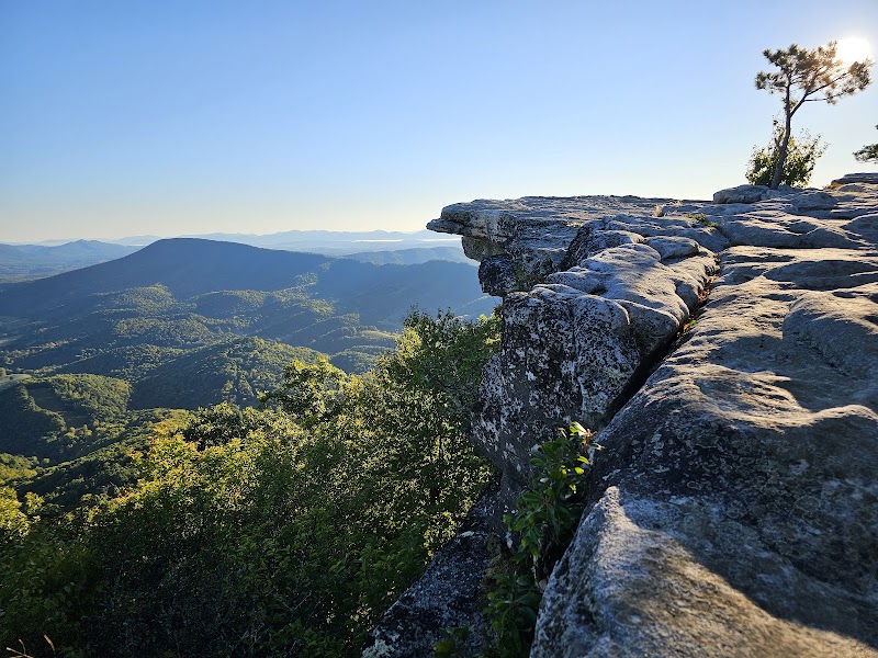
Roanoke, Virginia, offers hikers an authentic encounter with the Blue Ridge Mountains’ raw edges and quiet forests. The best trails near Roanoke embrace a variety of terrains—from easy river flats to challenging mountain climbs—each one beckoning with landscapes that shift from tranquil wooded corridors to panoramic ridgelines holding the skyline’s gaze.
What To Expect on These Trails
Expect forest paths alive with the rustle of wind and spotted with patches of sunlight filtering through oak and pine. The Roanoke River dares you to approach, its currents pushing forward, steady and relentless. Elevation gains vary but most hikes hold a practical challenge, rewarding each step with open clearings or views over the verdant valleys below.
Trails like the Mill Mountain Greenway combine accessibility with immersive nature, where city scenes momentarily yield to the sounds of twigs snapping and distant bird calls. For more skilled hikers, the Appalachian Trail segments just outside Roanoke offer a fierce but fair test, climbing rugged slopes where each foothold counts.
Planning Your Adventure
Proper preparation is key. Wear sturdy footwear suited for rocky or muddy stretches. Early morning or late afternoon hikes help avoid the heat and bring out wildlife encounters—white-tailed deer often pause just off the path, as though deciding whether you belong here. Hydration packs are a must; water sources can be limited depending on season.
Maps and trail markers are generally reliable, but cell reception fluctuates when deep in the wilderness. Carry a physical map or download offline GPS routes in advance. Keep an eye on weather—Virginia’s mountains can shift from sun to storm with little warning.
Beyond The Trails
This page showcases the best trails near Roanoke, Virginia with detailed guidance, and links below will lead you to the best adventures in Roanoke, Virginia for a full outdoor experience. Whether you seek the thrill of a ridge crest or a quiet walk beneath evergreen sentinels, Roanoke has a trail shaped for your pace and passion.
Nearby Trips
All Adventures
Boat Charters
Water Activities
Adventures near Roanoke, Virginia
Discover the unique and memorable adventures that make Roanoke, Virginia special.
Frequently Asked Questions
What are the best beginner-friendly trails near Roanoke?
Mill Mountain Greenway and Explore Park loop offer gentle terrain, well-marked paths, and rewarding views suitable for beginners and families.
Are dogs allowed on trails near Roanoke?
Dogs are permitted on many Roanoke-area trails but must be leashed. Always check specific park rules and bring water and waste bags.
When is the best time to hike for fall colors?
Mid-October to early November is peak foliage season near Roanoke, with leaves turning vivid reds, oranges, and golds.
Are the trails well marked and easy to navigate?
Most popular trails have clear markings and maintained paths, but for longer or backcountry routes, carrying a map or GPS is advised.
Can I find water sources along the trails?
Natural water sources exist but may not be reliable year-round. It's safest to bring sufficient water, especially during dry months.
Is there cell phone reception on the trails near Roanoke?
Cell signal varies; it’s generally available near trailheads but can drop off deeper into the backcountry. Offline navigation aids are recommended.
Recommended Gear
Sturdy hiking boots
Provides stability and grip for rocky or muddy sections common in mountain trails.
Hydration pack or water bottle
Essential to stay hydrated, especially on warm days or longer treks.
Layered clothing
Allows temperature regulation as mountain weather shifts.
Map or GPS device
Navigational tools are needed since cell service can be spotty on remote trails.
Local Insights
Hidden Gems
- "Dragon's Tooth Trail offers unique rocky outcrops and panoramic ridge views."
- "Tinker Cliffs, accessible from nearby, rewards hikers with extraordinary overlook points seldom crowded."
Wildlife
- "White-tailed deer often move quietly through the underbrush."
- "Look for pileated woodpeckers, whose drumming echoes through the forest."
- "Occasional black bear sightings in more remote areas, usually at dawn or dusk."
History
"Roanoke’s trails follow historic routes once used by Native American tribes and early settlers, with some sites near Civil War battlefields adding a layer of cultural significance."