Off the Grid: Jeeping the Alpine Loop Scenic Byway
The Alpine Loop Scenic Byway offers off-road enthusiasts an adventurous escape through Colorado’s rugged high country. Navigate rocky trails, soaring passes, and historic mining towns on this 65-mile jeep route designed for those ready to engage with a terrain as demanding as it is breathtaking.
Prepare Your Vehicle for Rocky Terrain
Ensure your jeep has high-clearance four-wheel drive, reliable off-road tires, and necessary recovery gear like tow straps and a winch. This route is rocky with uneven surfaces that challenge your rig’s capabilities.
Hydrate and Layer Clothing
Bring at least one gallon of water per person and dress in layers to manage temperature swings from valley bottoms to alpine passes. Weather can shift rapidly at high elevation.
Start Early to Avoid Afternoon Thunderstorms
Afternoon storms appear frequently in summer at high elevations. Begin your drive at sunrise to maximize daylight and stay clear of these unpredictable weather patterns.
Download Offline Maps and Carry Paper Backups
Cell signal disappears in many spots along the Loops. Use downloaded GPS maps and bring physical trail maps to ensure you don’t lose your way in the remote backcountry.
Off the Grid: Jeeping the Alpine Loop Scenic Byway
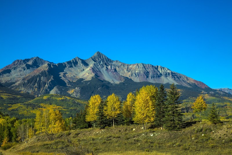
The Alpine Loop Scenic Byway carves a rugged path through Colorado’s high country, inviting jeepers and off-road enthusiasts to engage with a landscape that’s fiercely itself. Spanning roughly 65 miles of unpaved roads, this loop connects the historic mining towns of Ouray, Silverton, and Lake City, pushing vehicles—and drivers—to test their limits amid twisting mountain trails and towering peaks. Expect steep climbs and tight switchbacks, punctuated by glimpses of rivers daring you along the narrow ledges and forests that stand watch like patient guardians. Each turn offers a new angle on the wilderness, from snowmelt-fed creeks that chuckle beneath rocky fords to expanses of dense pine that offer brief reprieves from the sun.
Starting near Ouray (7,792 ft), the loop ascends past Engineer Pass and Cinnamon Pass, rising above 12,800 feet, where thin mountain air sharpens your senses and the world spreads wide below. These high points are more than just scenic overlooks—they’re testaments to endurance, demanding drivers respect the terrain’s unpredictable shifts of loose gravel and rocky obstacles. The terrain requires four-wheel-drive vehicles with high clearance and a skilled driver who understands recovery techniques and off-road safety.
Prepare wisely: early summer through early fall is the prime window, when snow has melted and trail conditions are stable. Pack water and layered clothing—temperatures at elevation can swing quickly, and the sun presses down harder up here. Rig your jeep with reliable tires suited for rocky paths, and bring a GPS or offline map alongside paper backups; cell service can disappear like a ghost around tight corners.
Timing is key. Start early to avoid afternoon storms common at high elevations and to secure daylight for longer stretches. Pit stops in Ouray or Silverton provide last-minute fuel and supplies, but once you’re on the Loop, the landscape calls for self-sufficiency. Respect the land by sticking to established trails, and watch for wildlife—mountain goats and mule deer often scan the roadsides, unbothered yet watchful.
This isn’t simply a drive; it’s a dialogue between machine, driver, and mountain. Each challenge—be it a steep incline or a narrow pass—asks for patience and preparation, inviting you to push forward with awareness. The Alpine Loop rewards with raw, untamed views, a chance to reboot in the alpine silence, and the satisfaction of meeting a terrain that will not be rushed or softened. For those ready to meet it on its own terms, the trip leaves an imprint far deeper than dust on metal.
Nearby Trips
All Adventures
Boat Charters
Water Activities
Adventures near Ouray, Colorado
Discover the unique and memorable adventures that make Ouray, Colorado special.
Frequently Asked Questions
Can anyone drive the Alpine Loop with a regular car?
No, the Alpine Loop requires a high-clearance, four-wheel-drive vehicle due to rocky sections, steep grades, and narrow passages. Regular cars risk damage or becoming stuck.
How long does it take to complete the Alpine Loop?
Most drivers take between 6 to 10 hours depending on stops, vehicle capability, and weather. Rushing is unsafe; allow time to navigate tricky sections and admire the surroundings.
Is this trail suitable for solo travelers?
While solo travel is possible, it’s recommended to travel with at least one other vehicle because some sections are remote with no cell service, making assistance essential in emergencies.
Are there places to refuel or resupply along the loop?
Fuel and supplies are available only in the towns of Ouray, Silverton, or Lake City. Plan accordingly before starting the loop as there are no services on the trail.
What wildlife might I encounter on the Alpine Loop?
Look for mountain goats, mule deer, marmots, and a variety of birds including golden eagles. Wildlife is generally wary but commonly seen near water sources or rocky outcrops.
Is camping allowed along the Alpine Loop?
Camping is permitted in designated dispersed sites within the San Juan National Forest. Always follow Leave No Trace principles and check local regulations before overnight stays.
Recommended Gear
Four-Wheel Drive Vehicle with High Clearance
Necessary to handle rocky, uneven terrain and steep grades safely.
Recovery Gear (tow straps, shovel, winch)
Equipment to self-recover or assist others when stuck or facing obstacles.
Layered Clothing
To adjust for rapid temperature changes and varying weather conditions at elevation.
Offline GPS Device or Trail Maps
Critical for navigation where cellphone coverage is unreliable or non-existent.
Local Insights
Hidden Gems
- "Blue Lakes Trail and Basin just off Engineer Pass offers a shimmering turquoise water contrast against rugged peaks."
- "The ghost town ruins near Animas Forks reveal early mining life and add depth to the historic journey."
Wildlife
- "Mountain goats frequent the upper rocky ledges near Cinnamon Pass, often sizing up adventurers from a safe distance."
- "Listen for the whistle of marmots on sunny rocks; they signal a thriving alpine ecosystem."
History
"The Alpine Loop follows routes forged during the Silver Boom of the late 19th century, weaving through mining towns where remnants of abandoned mills and stamp houses confront the passing of time."