Summit the Wild Majesty: Hiking Mount Greylock for Panoramic Multi-State Views
Experience the thrilling ascent to Mount Greylock, Massachusetts’ highest peak, where panoramic views stretch across four states. This guide balances vivid trail descriptions with practical advice to prepare you for a rewarding and manageable hiking adventure.
Start Early to Beat the Crowds and Heat
Begin your hike at dawn or early morning to enjoy cooler temperatures and a quieter trail, especially on weekends and peak seasons.
Bring at Least Two Liters of Water
Hydration is crucial on this 7-mile trek. Carry ample water and a portable filtration system if you want to refill from natural sources.
Wear Sturdy Footwear with Good Traction
Expect a mix of rocky and root-covered terrain that can be slippery when wet; trail runners or hiking boots with solid grip ensure safer footing.
Check Weather Before You Go
Mountain weather changes rapidly. Dress in layers, bring rain protection, and be prepared for wind at the summit to stay comfortable and safe.
Summit the Wild Majesty: Hiking Mount Greylock for Panoramic Multi-State Views
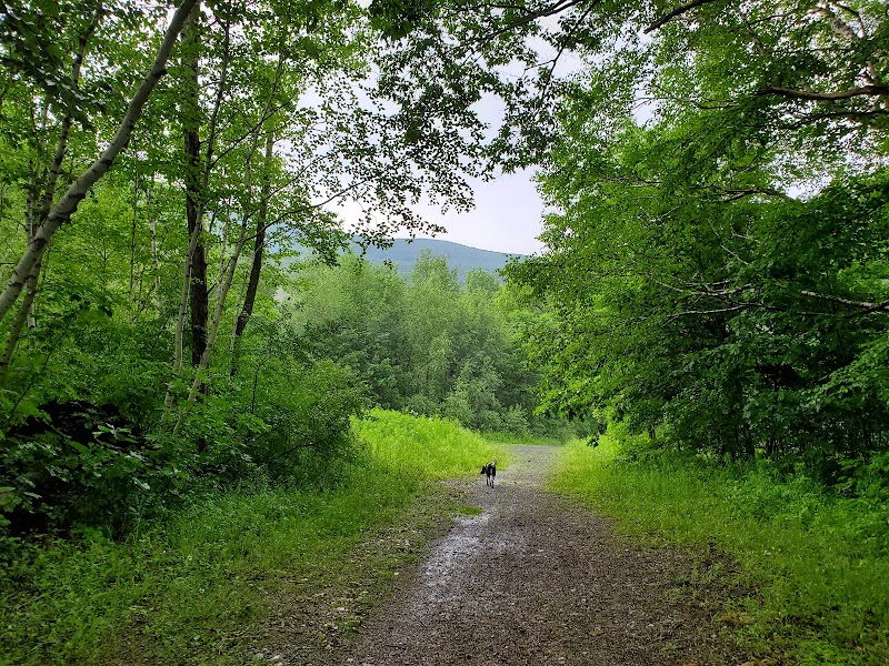
Mount Greylock stands as the highest point in Massachusetts, its summit a commanding vantage spilling views across four states on clear days. The hike here offers more than elevation; it’s an engagement with a landscape fiercely itself, where dense forests lean close and wind whips over rocky ledges daring you forward.
Starting at the base, expect roughly 7 miles round trip with an elevation gain near 2,000 feet—enough to test stamina without demanding technical climbing skills. Trails like the Appalachian and others wind through mixed hardwood forests where spring’s newborn leaves reach toward the sky and fall’s amber light filters through branches. Underfoot, roots grip earth and loose stones whisper of careful footing. The terrain varies—well-maintained paths mix with steeper stretches that reward effort with expanding views.
Hydration is non-negotiable. Water sources near trailheads provide a start, but bring at least two liters and a filtration method if you plan a longer trek. Footwear should be sturdy with good grip; the terrain can turn slick with dew or rain. Timing your ascent matters—early mornings typically offer cooler air and fewer crowds, while late afternoons can be brisk with the wind’s sudden charge.
At the summit, the iconic War Memorial Tower stands like a beacon. From here, vistas unfold—Vermont’s Green Mountains to the north, the Taconic Range westward, Connecticut’s hills to the south, and the distant Berkshires beneath. The sky often breathes with shifting layers of cloud and sunlight, creating a dynamic backdrop to the landscape’s calm spread.
Practical preparation meets wild reward. This hike requires respect: the mountain isn’t conquered; it’s encountered, each step an exchange with nature’s relentless character. With clear planning and measured vigor, summiting Mount Greylock becomes an adventure both accessible and richly satisfying.
Nearby Trips
All Adventures
Boat Charters
Water Activities
Adventures near North Adams, Massachusetts
Discover the unique and memorable adventures that make North Adams, Massachusetts special.
Frequently Asked Questions
How difficult is the hike to Mount Greylock’s summit?
The hike is moderately challenging with about 7 miles round trip and a 2,000-foot elevation gain. It requires good fitness and some experience on uneven terrain but no technical climbing skills.
Are there facilities at the summit?
Yes. The summit features the War Memorial Tower and a small visitor center with restrooms during the warmer months, plus picnic areas nearby.
Can I hike Mount Greylock in winter?
Winter hikes are possible but demand caution. Trails become icy and snow-covered, requiring winter gear like crampons and extra clothing layers for safety.
Is the trail dog-friendly?
Dogs are allowed but must be kept on leash to protect wildlife and other hikers.
What is the best time of day to summit for photography?
Early morning and late afternoon light offer the best photographic conditions with softer shadows and dynamic skies.
Are there alternative routes to the summit?
Several trails reach the summit, including the Appalachian Trail and the Thunderbolt Trail. Each varies in length and difficulty giving options based on your pace and preferences.
Recommended Gear
Trail Running Shoes or Hiking Boots
Provides traction and ankle support across variable rocky and root-laden pathways.
Water Bottle or Hydration Pack
Staying hydrated is critical, especially on warm, sunny days.
Layered Clothing
Allows adjustment to changing temperatures and wind, especially at the exposed summit.
Trekking Poles
Helpful for stability, particularly on steep or slippery trail sections.
Local Insights
Hidden Gems
- "The small pond near the base campsite offers a quiet spot for wildlife watching"
- "The Thunderbolt Ski Trail follows historic paths once used by adventurers racing the descent"
Wildlife
- "Look for black bears, white-tailed deer, and a variety of songbirds including northern parula warblers"
- "Rattlesnakes are rarely seen but can inhabit rocky ledges—stay alert"
History
"Mount Greylock’s summit features a 93-foot War Memorial Tower dedicated to Massachusetts veterans, blending natural and cultural heritage."