Backpacking the Sheltowee Trace: Kentucky's Longest Trail Through the Wild
The Sheltowee Trace offers a vast wilderness experience through Kentucky’s most rugged terrain, stretching over 300 miles from the Ohio River to Tennessee. This backpacking trail challenges adventurers with its varied landscapes and practical demands, perfect for those ready to meet the wild on its own terms.
Plan Water Resupplies Carefully
Water sources can be unreliable and vary by season. Carry enough water treatment options and confirm stream status ahead of time to avoid dehydration.
Wear Gripping Footwear
Expect mixed terrain: rocky ascents, slippery river crossings, and soft forest trails. Trail runners or sturdy hiking boots with solid grip are best.
Use Layered Clothing for Variable Weather
The weather shifts quickly on ridge tops and in forest hollows. Prepare with moisture-wicking base layers and waterproof outerwear.
Prioritize Navigation Skills
Trail markers can be sparse in some sections. Carry a map, compass, and GPS device and know how to use them to stay on course.
Backpacking the Sheltowee Trace: Kentucky's Longest Trail Through the Wild
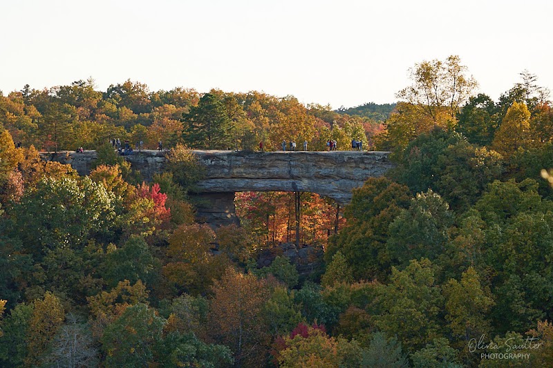
Stretching over 300 miles from northern Kentucky to the Tennessee border, the Sheltowee Trace offers an unfiltered encounter with the state’s most rugged wilderness. This trail threads through dense hardwood forests, rugged ridges, and alongside rivers that challenge your pace with their persistent currents. For backpackers seeking both solitude and complexity, the Sheltowee Trace stands as a demanding path that respects no shortcuts.
Starting near the Ohio River, the trail slips quietly beneath towering oaks and maples before climbing steep elevations near the Daniel Boone National Forest. Terrain shifts frequently—gritty, rocky ascents followed by soft earth paths cushioned with fallen leaves and pine needles. Along the way, sandstone cliffs peer down like watchful sentries, offering sweeping views that reward sweat and steady footwork.
Water is a constant partner, sometimes a gentle companion in clear streams, other times a bold force daring you to navigate carefully at crossings. Plan your water resupplies meticulously; while springs exist, their flow varies seasonally. Footwear needs to grip both wet rocks and dusty climbs—trail runners or light hiking boots strike the right balance.
Backpacking the Sheltowee Trace demands respect for the wilderness it inhabits. Weather shifts fast, so layering your clothing for changing temperatures and sudden rain is essential. Campsites range from primitive shelters to dispersed areas where you set your own zone of rest. Each step brings a conversation with nature — the rustling leaves, distant turkey calls, and the whisper of the wind in hollow branches all create a compelling rhythm.
Timing your journey plays a crucial role. Spring buds with wildflowers and vibrant greens; summer’s heat tests your endurance but fills the forest with life’s buzz; fall drapes the trail in color, making every ridge a photo opportunity; winter chills the air, challenging those who embrace cold-weather backpacking.
Navigating this trail is less about conquest and more about partnership with a force fiercely itself. Preparation, endurance, and a keen eye will unlock both the tangible sights and the intangible pulse of Kentucky’s wild heart. The Sheltowee Trace isn’t a trail to cross off—it’s a deep exchange with a landscape that doesn’t give up its secrets easily.
Nearby Trips
All Adventures
Boat Charters
Water Activities
Adventures near Morehead, Kentucky
Discover the unique and memorable adventures that make Morehead, Kentucky special.
Frequently Asked Questions
How long does it take to backpack the entire Sheltowee Trace?
Most thru-hikers complete the full trail in 10 to 14 days depending on pace and weather. Day hikers or section hikers can tackle parts in shorter trips.
Are there shelters or designated campsites along the trail?
Yes, the trail offers primitive shelters and dispersed camping areas, but many sections require self-sufficient wilderness camping, so plan accordingly.
Is the trail well-marked for navigation?
While marked with blazes and signage, some stretches have sparse markers. Carry maps, GPS, and compass as backup.
What are the biggest hazards on the Sheltowee Trace?
Steep terrain, unpredictable weather, insect activity, and water crossings during high flow are key challenges to anticipate.
Can I fish or swim along the Sheltowee Trace?
Fishing is permitted in many streams with proper licenses. Swimming is possible but exercise caution due to swift currents and seasonal water levels.
What wildlife might I encounter on this trail?
White-tailed deer, wild turkeys, black bears, and a variety of songbirds are common. Stay alert for snakes and practice safe wildlife etiquette.
Recommended Gear
Water Filtration System
Essential for treating water from streams and springs along the trail, ensuring safe hydration.
Sturdy Hiking Boots or Trail Runners
Required for protecting feet on varied terrain, providing grip on rocks and support on uneven ground.
Layered Clothing System
Allows adjustment for rapidly changing weather conditions from cool mornings to warm afternoons.
Compact Camping Stove
Useful for preparing hot meals and beverages, increasing comfort on multi-day backpacking trips.
Local Insights
Hidden Gems
- "The panoramic overlook at Raven Rock offers seldom-visited views of rugged ridgelines."
- "Buzzard’s Roost, a narrow sandstone cliff cave, provides dramatic geological interest off trail."
- "Little Laurel Creek Falls is a refreshing stop showcasing cascading water within shaded forest."
- "Pilot Knob shelter area has rich flora and often fewer hikers, offering peaceful campsite options."
Wildlife
- "Watch for timber rattlesnakes sunning on exposed rocks during warmer months."
- "Northern flying squirrels active at dusk add an unexpected encounter for night hikers."
- "Woodland salamanders come out during wetter periods and can be glimpsed under logs."
History
"The Sheltowee Trace follows paths once used by Native American tribes and early settlers. Its name honors Daniel Boone, 'Sheltowee' meaning 'Big Turtle' in Shawnee. Numerous relics and historic sites lie near sections of the trail."