The Great Idaho Bikepacking Loop offers an epic gravel bikepacking challenge through rugged mountains and deep forests, far from any cell signals. Experience raw solitude, relentless climbs, and breathtaking views on nearly 700 miles of winding trails.
Plan Your Water Stops Carefully
Water sources are sparse and unreliable along the route. Carry filtration gear and plan your refill points ahead to avoid dehydration.
Pack Layers for Mountain Weather
Temperatures shift rapidly from morning chill to afternoon warmth. Layering helps you stay comfortable and ready for sudden weather changes.
Bring Reliable Navigation Tools
Maps and GPS devices are crucial as cell service drops out in large sections. Download offline maps and carry a physical map as backup.
Prepare Your Bike for Rough Gravel
Tires with good tread and reinforced sidewalls reduce flats and improve control on rocky surfaces. Carry extra tubes and a repair kit.
The Great Idaho Bikepacking Loop: Gravel Roads, Rugged Mountains, and Zero Cell Service
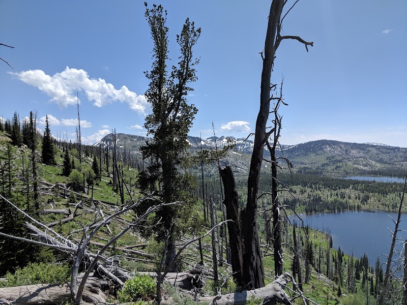
The Great Idaho Bikepacking Loop stretches nearly 700 miles through Idaho’s wild heart, challenging riders with a mix of gravel roads, steep mountain passes, and stretches where the silence is broken only by the churn of your tires on dirt. This route refuses to be tamed; it demands respect and readiness. If you’re chasing solitude far from cell signals, and an experience where nature dares you to keep moving forward, this is it.
Starting near the small town of McCall, the loop weaves through thick forests where pine trees lean over the trail like old friends watching your progress. Rivers cut across your path, pushing cool currents that invite you to pause, unwind, and refill. Elevation gains are relentless—expect to climb over 40,000 feet total, with technical sections that test your bike-handling skills on rocky, uneven gravel. Days can stretch to 60 or 70 miles between resupply points. Hydration and nutrition planning aren’t a luxury but a necessity.
Practical planning is as critical as the thrill of discovery. Pack lightweight, durable gear and bring reliable navigation tools since GPS signals can falter here. Cold mornings in the mountains shift swiftly to warmer afternoons, so layering is key. Footwear with solid tread is a must to handle varied terrain that ranges from smooth gravel paths to loose scree on long descents.
This loop moves through mountains fiercely protective of their silence. Wildlife like elk and black bears may cross your path without ceremony, reminding you that you’re a visitor. Camping spots offer dome-shaped clearings framed by towering idol-like trees—perfect for catching stars that scatter across the vast night sky.
Timing your ride between late June and early September maximizes good weather and minimizes snow hazards, but be prepared for sudden storms that can sweep through like a test. Cell service is near nonexistent; let that sink in. Each mile is an engagement with a landscape fiercely itself, offering challenge and reward to those who answer its call.
If you seek a trip defined by solitude, strenuous climbs, and wide-open spaces, the Great Idaho Bikepacking Loop delivers all that—and more. Bring your grit, your curiosity, and a readiness to embrace the unexpected. Here, adventure is not just in the miles but in the moments of silence and sweat, when the mountains seem to speak and you listen.
Nearby Trips
All Adventures
Boat Charters
Water Activities
Adventures near McCall, Idaho
Discover the unique and memorable adventures that make McCall, Idaho special.
Frequently Asked Questions
Is there cell phone coverage along the Great Idaho Bikepacking Loop?
Cell phone coverage is very limited or nonexistent for large stretches of the loop. Riders should prepare by downloading offline maps and carrying physical maps or GPS devices.
What level of experience is needed to attempt this bikepacking loop?
This loop is best suited to riders with intermediate to advanced gravel and mountain biking experience due to technical terrain, long daily distances, and remote conditions.
Where can I resupply food and water during the route?
Resupply points are few and far between, typically located in small towns such as McCall and Stanley. Plan carefully and carry extra provisions where necessary.
What wildlife might I encounter on the trail?
Elk, black bears, deer, and a variety of smaller mammals and birds inhabit the area. Staying alert and following wildlife safety guidelines is important.
When is the best time of year to ride the loop?
Late June to early September offers the most reliable weather conditions with minimal snow and passable trails.
Are there camping options along the loop?
Yes, dispersed camping is common. Look for designated sites or clearings away from water sources and follow Leave No Trace principles.
Recommended Gear
Hydration System with Filtration
Critical for staying hydrated; filtration allows you to use natural water sources safely.
Multi-layer Cycling Clothing
Allows quick adaptation to temperature swings from cold mornings to warm afternoons.
Durable Gravel Bike Tires
Enhances grip and puncture resistance on rough gravel and rocky surfaces.
Offline Navigation Devices or Physical Maps
Essential for route-finding due to minimal cell coverage.
Local Insights
Hidden Gems
- "Rattlesnake Gulch viewpoint offers panoramic views without the usual crowds"
- "Little Redfish Lake - a serene fishing spot often overlooked on the route"
Wildlife
- "Keep an eye out for mountain goats on rocky cliffs and osprey near river crossings"
History
"The loop traverses lands historically used by the Nez Perce tribe and early miners, with remnants of mining camps along abandoned sections."