Summiting Mount Whitney: The Ultimate Guide to California’s Tallest Peak
Mount Whitney, the tallest peak in the contiguous U.S., offers a challenging yet rewarding hike through California’s Sierra Nevada. From forested beginnings to high alpine terrain, this adventure combines stunning scenery with practical demands—perfect preparation ensures you experience the summit at its fullest.
Start Pre-Dawn to Beat the Heat and Crowds
Begin your hike early in the morning to avoid afternoon thunderstorms and experience cooler temperatures on the ascent.
Hydration Strategy Is Key
Carry at least 4 liters of water and consider a filtration system for snowmelt higher on trail; dehydration is a common risk at altitude.
Prepare for Altitude
Acclimate by spending time at higher elevations before the hike and recognize symptoms of altitude sickness early.
Wear Reliable Footwear
Use well-broken-in hiking boots with good ankle support to handle rocky, uneven terrain safely.
Summiting Mount Whitney: The Ultimate Guide to California’s Tallest Peak
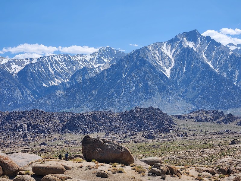
Mount Whitney stands as the tallest peak in the contiguous United States, a towering challenge that calls adventurers to test their endurance and skill. Rising to 14,505 feet, the hike from Whitney Portal near Lone Pine, California, is a nearly 22-mile round trip that rewards with panoramic views stretching from the Sierra Nevada to the Mojave Desert. The trail is fiercely alive, starting through shaded forests where the pines seem to whisper ancient stories. Streams crossing your path push forward with icy resolve, inviting careful steps.
The terrain changes with elevation: early miles wind through a forested incline, but as you climb higher, the environment sharpens. Granite boulders and scree fields demand steady footing, while the air thins and cools. The trail’s switchbacks engage legs and lungs alike, each turn revealing more of the vast landscape below. At Trail Crest, where elevation peaks just before the summit, the wind tests your balance and determination.
Reaching the summit is a moment charged with triumph but respect. Here, nature is fiercely itself—raw, open, and powerful. The breathtaking views are a testament to the journey, from snow-capped peaks to the stark, shimmering valley below.
To prepare, hydration must be rigorous—water sources dry up quickly above 10,000 feet, so carrying sufficient water or means to purify meltwater is essential. Sturdy footwear is non-negotiable; broken trail or rocky sections won’t forgive ill-equipped shoes. Start early to avoid afternoon storms, common in summer afternoons, and remember that altitude sickness is a real challenge, so listen to your body.
While the route is accessible to experienced hikers, it demands respect and readiness. The trail is not for novelty seekers but those willing to engage with a mountain that offers no shortcuts or illusions—only persistence and grit. Mount Whitney is not conquered, it’s met on its terms.
Nearby Trips
All Adventures
Boat Charters
Water Activities
Adventures near Lone Pine, California
Discover the unique and memorable adventures that make Lone Pine, California special.
Frequently Asked Questions
Do I need a permit to hike Mount Whitney?
Yes, permits are required year-round and must be obtained through a lottery system for peak season or reserved in advance. The quota system manages trail use to preserve the environment and hiker safety.
What is the best way to acclimate to the altitude?
Spend 1-2 days at intermediate elevations near Lone Pine or nearby higher elevation trails before attempting the summit, and ascend slowly on the hike to monitor any signs of altitude sickness.
Are there water sources on the trail?
Below 10,000 feet, there are some reliable streams early in the season. Above that, water is scarce or frozen most of the year, so carry enough or bring filtration for snowmelt.
How physically demanding is the hike?
The hike is long (about 22 miles round trip) with nearly 6,000 feet of elevation gain, requiring high stamina, strong legs, and cardiovascular fitness.
Can beginners attempt Mount Whitney?
It is recommended only for well-prepared, fit hikers with some high-altitude experience; beginners should train extensively and consider hikes at lower elevations first.
What wildlife might I encounter?
Expect marmots, pikas, and occasional bighorn sheep; birds like the Clark’s nutcracker are common. Keep a respectful distance and do not feed wildlife.
Recommended Gear
Hydration System with Filter
Keeps you hydrated where water sources vanish; filtration allows safe use of snowmelt or natural sources.
Sturdy Hiking Boots
Protects feet and ankles on rocky paths and scree fields, providing needed support.
Layered Clothing
Allows adjustments to rapidly shifting temperatures, essential for comfort and safety.
Trekking Poles
Help distribute the effort on steep climbs and descents, reducing fatigue and improving balance.
Local Insights
Hidden Gems
- "Army Pass offers stunning views of the south side of Whitney and the Alabama Hills below."
- "Lone Pine Lake, a serene alpine body of water along the trail, is a peaceful resting spot often overlooked."
Wildlife
- "Mountain yellow-legged frogs in isolated lakes."
- "Bighorn sheep grazing the higher ridges, elusive but rewarding to spot."
History
"Mount Whitney was first summited in 1873 by Charles Begole, A. H. Johnson, and John Lucas under the leadership of the California Geological Survey. The area holds cultural significance for the Owens Valley Paiute tribe."