Gravel & Ghost Towns: Bikepacking Through Colorado's Mining History
Explore Colorado’s mining past on a rugged gravel bikepacking route that threads through ghost towns and wild mountain terrain. This journey invites riders to tackle challenging climbs and variable surfaces while immersing in history and sweeping alpine views.
Carry Extra Water & Purification
Water sources can be scarce and unreliable along the route, especially in drier months. Bring at least 3 liters and a portable filter or purification tablets to stay hydrated.
Choose Wider Tires for Gravel
Opt for tires 2.2 inches or wider to handle loose gravel and rocky terrain comfortably without sacrificing rolling speed on packed dirt.
Start Early to Avoid Storms
Afternoon thunderstorms are common at elevation in summer. Early departures reduce risk from weather and help you cover maximum distance in daylight.
Pack Layered Clothing
Temperature swings from low valleys to high ridges require adaptable clothing—think moisture-wicking layers, insulating mid-layers, and a windproof shell.
Gravel & Ghost Towns: Bikepacking Through Colorado's Mining History
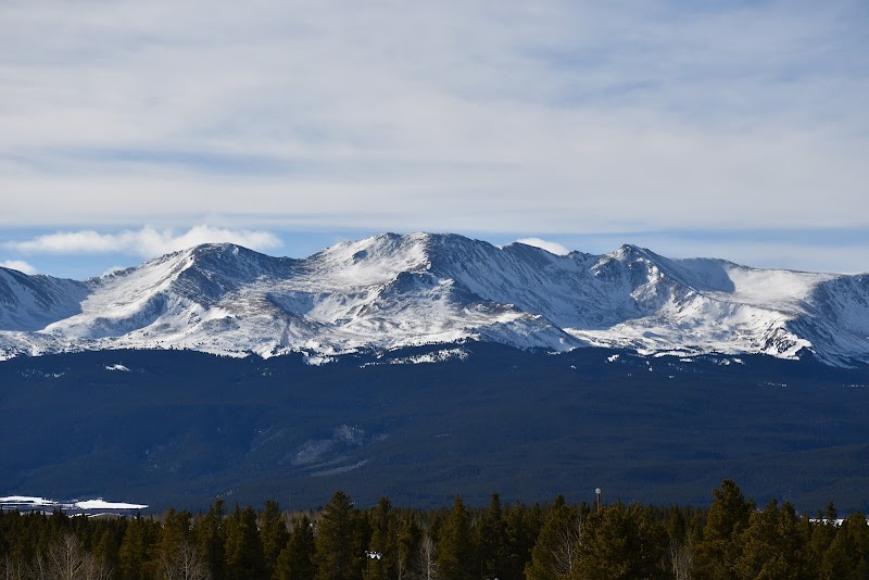
Bikepacking through Colorado’s rugged mining country is an adventure that mixes history, grit, and raw nature. The gravel roads here wind through scorched ridges, dense forests, and abandoned settlements where time has stalled—the ghost towns stand silently, daring riders to uncover their stories. Starting near Leadville, you’ll face 50-70 miles of variable terrain, ranging from rocky singletrack to hard-packed dirt roads, with elevation gains approaching 5,000 feet. These climbs push you upward through pines and aspens, where the currents of mountain streams whisper past, urging you forward toward old mining ruins and weathered cabins.
This journey is less about speed and more about discovery. The roads weave through haunting remnants of the mining boom—collapsed stamp mills, forgotten shafts, and rusty rail lines that once hauled precious ore. Each ghost town, from St. Elmo to Winfield, offers a tactile connection to Colorado’s extractive past paired with the austere beauty of high alpine desert. Tread carefully; nature here is fiercely itself—unpredictable weather changes and steep drop-offs require focus and respect.
Hydration and tire choice are your top priorities. Water sources can be sparse and unreliable, so carry at least three liters and filter options. Opt for wide tires (2.2 inches or more) to tame loose gravel and rocky patches while maintaining efficiency on smoother dirt. Start early to avoid afternoon thunderstorms, common at summit elevations. Layered clothing is vital: temperatures swing dramatically from sun-drenched valleys to shaded forested climbs.
Along the route, the forested sections hum with pines and firs, while open ridges reveal sweeping views of jagged peaks that seem to dare you higher. Wildlife such as mule deer and occasional elk move stealthily, their presence a reminder that you’re sharing this land with creatures adapted to thrive in tough conditions.
Prepare for solitude mixed with bursts of history. While some ghost towns attract visitors, most trails maintain quiet. Route navigation can be tricky as signage is minimal—phone GPS with offline maps or a detailed paper topo will be your best companions. This bikepacking trip is a strong challenge but rewards with gritty beauty, hands-on history, and the quiet pulse of Colorado’s wild heart.
Nearby Trips
All Adventures
Boat Charters
Water Activities
Adventures near Leadville, Colorado
Discover the unique and memorable adventures that make Leadville, Colorado special.
Frequently Asked Questions
How difficult is the route for a beginner bikepacker?
The route is challenging due to variable terrain and elevation gain. Beginners should have some gravel riding experience and be comfortable with long climbs and self-supported travel. Consider shorter segments to build skills.
Are ghost towns easy to access along the gravel roads?
Most ghost towns like St. Elmo lie just off the main gravel routes and are accessible by bike. Some may require short hikes or detours on singletrack, but clear signage is limited—detailed maps help.
What is the best way to navigate the route?
Use GPS devices with offline maps or detailed topographic maps. Mobile signal is spotty, so offline navigation apps or paper backups are essential.
Can I find water en route?
Natural water sources are limited and can be seasonal or contaminated. Bring enough water and a reliable filtration system to ensure safe drinking water.
When is the best time to visit the ghost towns by bike?
Late June through September offers the most stable weather and clear trail conditions. Early spring and late fall can be cold and snowy at higher elevations.
Are there camping options along the ride?
Dispersed camping is permitted in most of the national forest lands surrounding the route. Some ghost towns permit camping nearby, but amenities are minimal, so self-sufficiency is key.
Recommended Gear
Hydration System (3+ liter capacity)
Staying hydrated is critical, especially in dry mountain air and summer heat.
Gravel Bike with Wide Tires
Wide tires provide grip and comfort over mixed gravel and rocky terrain typical on ghost town routes.
Layered Clothing
Temperature swings demand versatile clothing to stay comfortable and dry.
Portable Bike Repair Kit
Essential for fixing flats or mechanicals where help is hours away.
Local Insights
Hidden Gems
- "Viewing the untouched ruins of Winfield, less visited and quieter than St. Elmo"
- "A secluded alpine meadow near Mosquito Pass with wildflower bursts and mountain views"
Wildlife
- "Mule deer browsing forest edges"
- "Occasional elk herds in early morning"
- "Raptors circling thermals near ridges"
History
"This network of gravel roads follows veins of Colorado’s late 19th-century mining boom, where precious metals shaped the state’s growth. Ghost towns here preserve original structures, revealing stories of boom, bust, and abandonment."