Lake Superior Trail Trek: Mastering the Superior Hiking Trail
The Superior Hiking Trail follows Lake Superior’s wild North Shore for over 300 miles, offering backpackers a rugged adventure through forests, cliffs, and lakeside views. Whether you’re a seasoned trekker or a casual hiker, this trail combines breathtaking scenery with practical challenges for an unforgettable outdoor experience.
Hydrate from Natural Water Sources
Streams and lakes are plentiful, but always filter or treat water to avoid illness.
Wear Trail-Ready Footwear
Expect rocky, uneven terrain requiring sturdy boots with solid grip and ankle support.
Start Early to Maximize Daylight
Longer summer days mean you can cover more miles safely and enjoy scenic viewpoints in optimal light.
Prepare for Weather Variability
Mountain and lakeside microclimates shift quickly; pack layers and rain protection even in summer.
Lake Superior Trail Trek: Mastering the Superior Hiking Trail
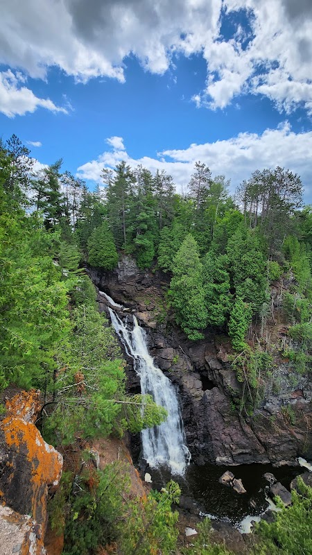
The Superior Hiking Trail (SHT) stretches over 310 miles beside Lake Superior’s rugged North Shore, inviting backpackers into a realm where wilderness pushes back and views reach to infinity. Each step presses into dense forests of pine and birch, crossing streams that dare you to keep pace. The trail is fiercely itself—rocky ridges roll like ancient waves, and the lake’s cold breath sweeps across cliffs, reminding you that you’re part of something vast and elemental.
Starting in Duluth, Minnesota, the SHT challenges with varied terrains: from gentle boardwalks over marshes to steep, rocky ascents with cumulative elevation gains totaling around 35,000 feet along the entire trail. Popular sections such as the Tettegouche State Park and Judge C.R. Magney State Park provide accessible day hike options or multi-day trips with well-maintained campsites. Plan for 12 to 14 days if you’re through-hiking.
Waterways spill into Lake Superior, their currents pushing forward with quiet insistence. Hydration is crucial—treat or filter lake or stream water regularly. Footwear should be durable with good ankle support; trail conditions range from loose gravel to slick roots and boulders. Timing your trek between June and September offers the most stable weather, with fewer midges and longer daylight.
Beyond logistics, the trail hums with life. Watch for black bears lumbering through underbrush, osprey stalking fish below cliffs, and wild blueberries ripening late summer. The deep forest smells of earth and resin, the breeze occasionally carrying a salty tang from the lake.
Challenges come too: sudden storms can blow across the open ridges, and some remote portions demand self-sufficiency in navigation and emergency preparedness. Respect this wild corridor—move deliberately, read the weather, and leave no trace.
The Superior Hiking Trail combines raw wilderness and practical pathways, making it a defining backpacking adventure for those ready to walk where the land is truly alive. With sturdy gear, a mindful pace, and a readiness to adapt, the SHT offers a tangible connection to one of America’s least tamed coastlines.
Nearby Trips
All Adventures
Boat Charters
Water Activities
Adventures near Duluth, Minnesota
Discover the unique and memorable adventures that make Duluth, Minnesota special.
Frequently Asked Questions
How long does it take to hike the entire Superior Hiking Trail?
Most thru-hikers complete the full 310-mile trail in 12 to 14 days, averaging around 22 to 26 miles per day, depending on fitness and trail conditions.
Is the Superior Hiking Trail accessible for beginners?
Sections of the trail are suitable for beginners, especially shorter day hikes near state parks like Tettegouche. Full thru-hikes demand more experience and preparation.
What kind of wildlife might I encounter?
Common sightings include black bears, white-tailed deer, osprey, and occasionally moose. Insects such as mosquitoes and black flies can be prolific during warmer months.
Are there reliable water sources along the trail?
Yes, multiple streams and lakes provide water, but it’s essential to treat or filter water before drinking due to natural contaminants.
What permits or fees are required?
There is no permit requirement to hike the trail itself, but some state parks and campsites along the route may charge fees or require passes.
What are the best months to hike the Superior Hiking Trail?
June through September are best for weather and trail conditions, with July and August offering the longest days. Early fall offers cooler temps and spectacular foliage but can bring early snow.
Recommended Gear
Sturdy Hiking Boots
Protects feet and ankles on rocky and uneven terrain.
Water Filter or Purification Tablets
Ensures access to safe drinking water from natural sources.
Layered Clothing System
Adapts to changing temperatures and weather conditions along the trail.
Lightweight Tent or Shelter
Provides protection from weather and insects during overnight stays.
Local Insights
Hidden Gems
- "McCarthy Beach State Park’s secluded campsites"
- "The Devil’s Kettle waterfall—where water disappears mysteriously"
- "The lonely ridge near Carlton Peak overlooking Lake Superior"
Wildlife
- "Watch for the majestic bald eagle circling above cliffs"
- "Listen for the call of the common loon echoing over quiet lakes"
History
"The Superior Hiking Trail follows old logging roads and Native American portage routes, reflecting the region’s rich timber and Ojibwe heritage."