Hiking Table Rock: Conquer South Carolina’s Blue Ridge Escarpment for Epic Views
Experience the rugged beauty and broad panoramas of Table Rock, a key peak in South Carolina’s Blue Ridge Escarpment. This moderate 4-mile round trip hike offers forested terrain and a rocky summit with commanding views, ideal for adventurers ready to connect with a fiercely natural landscape.
Start Early to Beat the Heat
Morning hikes offer cooler temperatures and clearer skies, reducing the risk posed by afternoon thunderstorms common in summer months.
Wear Sturdy Hiking Shoes
Traction and ankle support are vital due to exposed roots and granite slabs, ensuring safer footing on steep sections.
Carry at Least 2 Liters of Water
Hydration is critical; the trail's exposed summit and sustained climb can dehydrate you quickly, especially in warmer seasons.
Be Aware of Changing Weather
Mountain weather shifts fast—bring a lightweight rain jacket and check the forecast before setting out to avoid getting caught in storms.
Hiking Table Rock: Conquer South Carolina’s Blue Ridge Escarpment for Epic Views
Ascending Table Rock is a straightforward adventure in South Carolina’s Blue Ridge Escarpment that rewards effort with broad vistas and a rugged mountain experience. The trail begins in the forest, where pine needles cushion your steps and oaks lean over the path like silent guides. As you advance, the climb ramps up—steep rock faces and roots push you forward, testing steady footing and resolve. Covering just under 4 miles round trip with an elevation gain near 2000 feet, the trail demands a moderate level of fitness but remains accessible for many hikers who come prepared.
The terrain is a mix of packed dirt, exposed roots, and granite slabs that the mountain insists you respect. The air here has a cool clarity, whispering through rhododendron thickets and hickory groves. Midway, a series of switchbacks leads you closer to the summit’s edge, where stone outcrops dare you to step near and take in the panoramic landscape. The Blue Ridge Escarpment stretches out—rolling ridges and valleys unfolding with rich greens, especially vibrant in spring and fall.
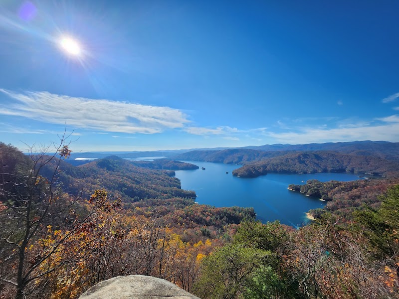
Reaching the peak, you encounter a sharp rocky dome that stands fiercely itself, a vantage point that commands sweeping views of Table Rock Reservoir and distant mountain ridges. Take a breath. The wind here acts like a vigilant companion, reminding you that nature holds its position with quiet power. Keep safety in mind and avoid the edges during strong gusts. Whether you’re here for a brisk morning climb or a late afternoon retreat, timing your hike to avoid midday heat and afternoon thunderstorms is wise.
Packing plenty of water and wearing sturdy footwear with good traction will keep you comfortable and sure-footed. Cell service can be spotty, so plan accordingly if you’re hiking solo or relying on digital maps. Local parking is at the Table Rock State Park main lot, where facilities offer a convenient start and end to your journey.
Table Rock isn’t just a destination—it’s an encounter with a landscape shaped by ancient geological forces. The mountain doesn’t yield easily, but it grants moments of clear-eyed beauty. For outdoors lovers craving a challenge coupled with accessible trail infrastructure, this hike sets a practical yet memorable outdoor adventure within South Carolina’s Blue Ridge Escarpment.
Nearby Trips
All Adventures
Boat Charters
Water Activities
Adventures near Clemson, South Carolina
Discover the unique and memorable adventures that make Clemson, South Carolina special.
Frequently Asked Questions
How difficult is the hike to Table Rock's summit?
It is classified as moderate with a 4-mile round trip distance and approximately 2000 feet of elevation gain. The trail includes rocky sections and some scrambling, suitable for hikers with a reasonable fitness level.
Is the trail well-marked and maintained?
Yes, the trail is well-marked and regularly maintained by Table Rock State Park. Trail junctions are clearly signed, but caution is advised on rocky, uneven sections.
Can beginners attempt this hike?
Beginners who are in good shape and prepared with proper gear can complete this hike. Starting early, pacing yourself, and taking breaks on the ascent help manage the moderate challenge.
Are dogs allowed on the trail?
Dogs are allowed on the trail but must be kept on a leash. Owners should bring water and watch for ticks and heat stress during summer.
When is the best time of day to hike for photography?
Early morning and late afternoon provide the best light for capturing the landscape, with less harsh shadows and calmer winds near the summit.
Is there cell phone reception on the trail?
Reception is spotty and unreliable in some sections, especially near the summit. Hikers should not rely on phone GPS and consider offline maps.
Recommended Gear
Hiking Boots with Good Traction
Provides ankle support and grip on mixed dirt and rocky terrain, vital for safe climbing and descents.
Hydration Pack or Water Bottles
Sustains energy and prevents dehydration; aim for at least 2 liters per person.
Layered Clothing
Allows adjustment to temperature changes, especially at the summit where winds can drop temperatures quickly.
Lightweight Rain Jacket
Protects against sudden showers or wind, common in mountain weather.
Local Insights
Hidden Gems
- "Hidden waterfall viewpoint on a side trail near the trailhead"
- "Small rock ledges below the summit that offer quiet solitude and partial views"
Wildlife
- "White-tailed deer often roam the forest floor, and timber rattlesnakes may be present in rocky areas during warmer months"
- "Listen for woodpeckers and warblers that dart through the rhododendron thickets"
History
"Table Rock's name derives from its flat-topped summit resembling a table. The mountain and surrounding lands were important to native Cherokee communities and later became a key conservation focus during the New Deal era."