Explore the rugged beauty of the Samuel H. Boardman Scenic Corridor, where coastal forests meet dramatic cliffs and hidden coves. This guide covers everything from trail options and terrain to practical tips ensuring your hike along the Oregon coast is both breathtaking and well-planned.
Start early to avoid crowds and capture morning light
Morning hikes provide calmer winds and better chances for clear ocean views, ideal for both photography and quiet reflection.
Wear layered clothing and sturdy shoes
The weather changes quickly near the coast; durable, slippery-resistant footwear and layers protect against damp, wind, and fluctuating temperatures.
Bring enough water and trail snacks
Most trails lack facilities; stay hydrated and energized, especially when tackling longer loops with elevation gains or uneven terrain.
Respect tide schedules for coastal access
Tide pools and beach stretches appear only at low tide. Check tide charts to plan visits and avoid being stranded or caught by rising waters.
Tracking the Oregon Coast: Hiking Samuel H. Boardman Scenic Corridor
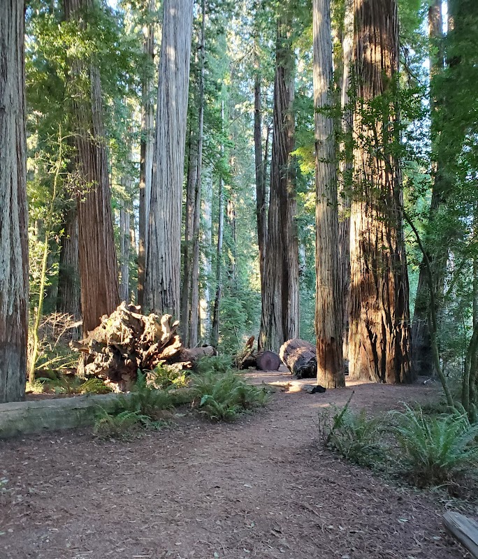
Stretching along Oregon’s southwestern coast near Brookings, the Samuel H. Boardman Scenic Corridor invites hikers to engage with a fiercely dynamic coastline where cliffs and coves shift under relentless wind and wave. This 12-mile corridor offers a series of interconnected trails ranging from short, sharp spur hikes to longer treks, each delivering raw views of the Pacific Ocean’s restless surge. The terrain is a blend of forested paths weaving through Sitka spruce and shore pine, grounding you in damp earth and salt-tinged air, while sporadic clearings put panoramic ocean vistas at arm’s length.
The primary trailhead near the town of Brookings launches you into a landscape that challenges and rewards in equal measure. Distances vary—easy access points like the Arch Rock Loop provide a manageable 1.5 miles with minimal elevation changes, while trails like the Natural Bridges Loop extend to roughly 4.2 miles with moderate climbs and rocky sections demanding good footing. Expect elevation gains of 200 to 600 feet, enough to fatigue the legs but under the threshold of strenuous climbs. Terrain toggles between soft, moss-covered earth and exposed roots, requiring sturdy hiking shoes with good traction.
Water and wind are constant actors here. Coastal winds push hikers toward the interior forest, where shade unfolds beneath a dense canopy, contrasting sharply with open viewpoints where the ocean seems to dare you closer. Tides accentuate the drama, revealing hidden tide pools and offshore stacks during low tide—perfect moments for a pause. Early mornings offer calm seas and less wind, while afternoons bring stronger gusts and shifting cloud cover, painting skies with both cobalt and slate.
Practical preparation is key. Carry at least 2 liters of water and layers to protect against sudden drops in temperature and wind. Waterproof footwear isn’t a bad idea during the wetter months. Start hikes early to catch daylight on the coast’s most photogenic spots. Facilities are sparse; pack out all trash and respect fragile vegetation.
The corridor is not just a collection of scenic overlooks but a place of continuous movement and quiet resilience. Hikers here meet an environment fiercely itself, demanding attention and respect but granting unforgettable rewards—sweeping coastal panoramas, the aroma of salty forests, and a reminder that some journeys pulse not with ease, but with the thrill of presence in an untamed world.
Nearby Trips
All Adventures
Boat Charters
Water Activities
Adventures near Brookings, Oregon
Discover the unique and memorable adventures that make Brookings, Oregon special.
Frequently Asked Questions
How long is the main hiking route through Samuel H. Boardman Scenic Corridor?
The corridor offers multiple trails ranging from short 1.5-mile loops to longer 4-6 mile loops. Full exploration across several connected trails can total 12 miles.
Are dogs allowed on the trails?
Yes, dogs are allowed but must be kept on-leash to protect local wildlife and preserve trail safety.
What is the best time of day to see wildlife or tide pools?
Early morning to mid-morning is best for wildlife activity and low tide reveals tide pools rich with marine life.
Is the trail accessible in winter months?
Yes, but expect wet and slippery conditions with shorter daylight hours. Proper gear and caution are necessary.
Do I need a permit to hike here?
No permit is required to hike the corridor, but parking may require a day-use fee depending on the lot.
Are there restroom facilities along the trail?
Restrooms are limited and mostly located at major trailheads; plan accordingly.
Recommended Gear
Waterproof hiking boots
Keeps feet dry and securely planted on slippery roots and rocks, especially during wet fall hikes.
Layered clothing (windbreaker and moisture-wicking base)
Adjust layers to shifting coastal weather, protecting against wind chill and moisture.
Hydration system (minimum 2L water)
Staying hydrated is crucial, as potable water sources are not available on trail.
Portable tide chart or app
Essential for planning beach explorations and avoiding hazardous tide conditions.
Local Insights
Hidden Gems
- "Secret Beach Cove accessible only at low tide near Natural Bridges"
- "Lone Ranch Beach viewpoint offers less trafficked panoramic views southward"
Wildlife
- "Roosevelt elk occasionally graze near forest edges"
- "Harbor seals haul out on offshore rocks and tide pools"
History
"Named after Samuel H. Boardman, Oregon’s first highway director, the corridor preserves coastal lands acquired during the mid-20th century to protect scenic and ecological values."