Best Scenic Day Hikes Near Pisgah National Forest: Exploring Hidden Waterfalls and Ridge Lines
Discover Pisgah National Forest’s top day hikes where hidden waterfalls challenge your path and ridge lines offer commanding views. This guide balances vibrant trail descriptions with practical tips to help you plan your ideal outdoor adventure.
Start Early to Beat Afternoon Storms
Mountain weather in Pisgah can shift rapidly; beginning hikes before 9 a.m. reduces risks and lets you enjoy cooler conditions on steeper climbs.
Hydrate and Carry a Water Filter
Streams are plentiful but treat water before drinking—either filter or bring enough water to stay fully hydrated.
Wear Supportive Footwear with Good Traction
Trails alternate between slick rocks near waterfalls and loose dirt on ridges; trail shoes or boots with ankle support minimize slips and ankle twists.
Keep Maps or GPS Handy
Cellular signals can vanish in deeper forest sections. Having offline maps or GPS devices reduces navigational risks.
Best Scenic Day Hikes Near Pisgah National Forest: Exploring Hidden Waterfalls and Ridge Lines
Pisgah National Forest invites you to trace paths where waterthreads dare through mossy boulders and ridge lines carve the horizon with rugged precision. This guide covers the best day hikes offering a blend of calm forest trails, sudden waterfall surprises, and panoramic ridge views, ideal for anyone looking to engage with the landscape on its own terms.
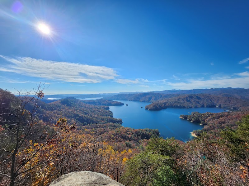
Start with the John Rock Trail, a moderate 3.5-mile round trip ascending roughly 1,000 feet. The path winds through spruce and fir, the trees standing like watchful guardians while the wind pushes softly at your back. The reward lies in the sweeping views over Looking Glass Rock and the valley below—clear and vast when the sun hits midday. The terrain is mostly packed dirt with some rocky steps, so solid footwear is necessary.
Next, the Graveyard Fields Loop spans 3.2 miles and offers a gentler elevation change around 500 feet. Its name echoes from an 1800s clearing, but today the trail ambles beside cascades that sing with chilly urgency and beneath rhododendron tunnels. Watch your footing over wet rocks near waterfalls, and prepare for the occasional mist that clings like breath to the forest.
For a longer challenge, the Art Loeb Trail section from Campbell Creek to Pilot Cove covers roughly 6 miles one way with an elevation gain near 1,900 feet. Here, the terrain toughens: rocky, steep at times, with ridge lines that put you face to face with the fierce blue ridge mountains stretching endlessly. The breeze high here feels like an active force, urging hikers forward or warning against complacency.
Hydration is key—streams can be refreshing but treat them cautiously or carry a filter. Start hikes early for cooler temperatures and avoid the afternoon when slopes may heat or storms build. Footwear with solid tread and ankle support will help with wet, uneven paths. Layer clothes for quickly changing mountain weather, and carry a map or GPS since cell signals fade in deep forest pockets.
Each trail interacts closely with its environment. Waterfalls don’t merely flow but push and challenge, forests offer shelter and whisper caution. Ridge lines do not just open views but demand respect for their raw exposure. Pisgah welcomes hikers of all levels, from casual ramblers to those craving high-altitude rewards. Choose the hike that fits your pace, prepare well, and the forest’s stories will unfold steadily, wildly, and with clear purpose.
Nearby Trips
All Adventures
Boat Charters
Water Activities
Adventures near Brevard, North Carolina
Discover the unique and memorable adventures that make Brevard, North Carolina special.
Frequently Asked Questions
Are dogs allowed on these trails?
Most trails in Pisgah National Forest welcome dogs but be sure to keep them on leash and watch for wildlife, especially during sensitive seasons.
What’s the best time to see waterfalls at their peak flow?
Spring is ideal as melting snow and rains boost waterfall volumes; early mornings offer the clearest views before trail crowds arrive.
Are there any safety concerns with the ridge trails?
Ridges are exposed to strong winds and sudden weather changes, so check forecasts, dress accordingly, and avoid if storms are expected.
Is camping available near these day hikes?
Pisgah offers several backcountry camping areas, but day hikes are primarily designed for same-day return; check local regulations for campground access.
What wildlife might I encounter on these hikes?
Expect to see white-tailed deer, various songbirds, and sometimes black bears; carry bear spray if hiking remotely and respect wildlife distances.
Are these trails accessible year-round?
Yes, but winter conditions can make some routes icy and hazardous. Spring through fall provides the safest and most rewarding experiences.
Recommended Gear
Trail Running Shoes or Hiking Boots
Offer grip and ankle support essential for rocky and wet terrain.
Hydration System or Water Bottles
Keep fluids accessible to maintain energy and balance, especially on longer or hotter days.
Light Layered Clothing
Allows quick adaptation to temperature shifts and wind near ridges.
Water Filter or Purification Tablets
Useful if you plan to refill from streams safely during longer hikes.
Local Insights
Hidden Gems
- "Hidden swimming holes under Slickrock Falls"
- "Quiet viewpoint near Calloway Peak off the Art Loeb Trail"
- "Old logging roads turning into peaceful side paths along Daniel Ridge"
Wildlife
- "Black bears roaming low valleys in early morning"
- "Eastern box turtles frequenting shaded wetland edges"
- "Migratory songbirds like the cerulean warbler passing through in spring"
History
"Pisgah National Forest includes lands that once supported extensive logging in the early 1900s. Many ridges and valleys bear old railroad grades repurposed as hiking trails today."