Explore over 190 miles of dynamic trails in Boise’s Ridge to Rivers system, where foothills and cityscape converge. Find routes for all skill levels marked by forest shade, rugged climbs, and panoramic ridges that reward preparation and curiosity.
Stay Hydrated and Fueled
Carry at least 2 liters of water, especially in summer, and pack high-energy snacks to sustain your energy on longer loops.
Wear Sturdy Hiking Shoes
Select footwear with good traction and ankle support to tackle rocky terrain and loose dirt sections with confidence.
Plan Your Route Ahead
Download the trail maps or apps beforehand; the Ridge to Rivers network is extensive, and signals can be patchy.
Start Early or Late
Avoid midday heat in summer by hiking during cooler, golden-hour times to maximize comfort and views.
Trailblazing Boise’s Ridge to Rivers: Adventure and Insight in the Foothills
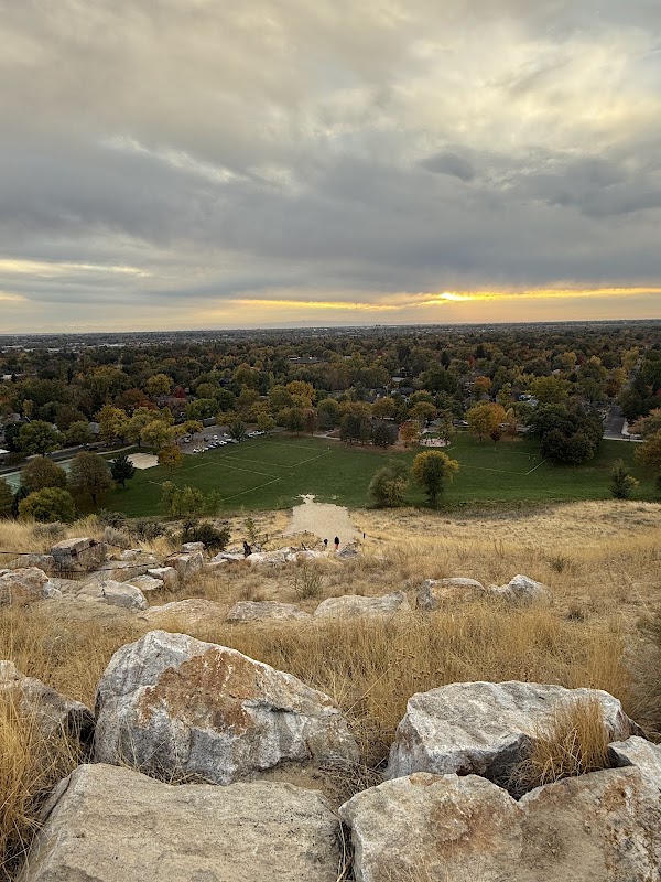
Boise’s Ridge to Rivers trail system spans over 190 miles, winding through the forested foothills that edge the city. It’s a network alive with rugged trails, steady climbs, and open ridgelines that challenge and invite hikers of all kinds. Starting from trailheads like the Table Rock or Military Reserve, you’ll encounter terrain that shifts from dense pine groves where sunlight sifts softly through the canopy, to open rock faces revealing the city tucked below like a well-guarded secret. The trails push you to engage with an environment fiercely itself—dry sagebrush at your side daring you forward, and creek crossings that ripple with insistent currents.
Distances vary widely, from short loops around 3 miles to extensive journeys topping 15 miles, with elevation gains ranging between 500 to 1,200 feet depending on your route. This variability makes Ridge to Rivers approachable for beginners while still offering seasoned hikers satisfying challenges.
The foothills’ weather tends toward dry and crisp in spring and fall, but summers can heat quickly, turning the earth dusty and the shade precious. Hydration is not optional here; the trails ask for steady water intake and sturdy footwear with good grip to handle rocky patches and occasional loose dirt. Early mornings or late afternoons are prime windows for avoiding heat while soaking in the golden light flooding the ridges.
Maps and trail markers are well maintained, but the system’s complexity calls for preparation: download trail maps ahead, note your starting and ending points, and carry a portable phone or GPS device. Wildlife sightings of mule deer and red-tailed hawks are frequent, a sign the environment here has control over its own rhythm.
Most hiking routes invite a pace that lets you absorb the interplay between Idaho’s rugged foothills and the urban edges of Boise. Keep your camera ready for sweeping views at spots like Camel’s Back or Hulls Gulch, where cliffs drop sharply to the valley below. Ridge to Rivers is not a trail system to conquer but to listen to, with every rocky step and wind-swept crest a conversation with the hills.
Nearby Trips
All Adventures
Boat Charters
Water Activities
Adventures near Boise, Idaho
Discover the unique and memorable adventures that make Boise, Idaho special.
Frequently Asked Questions
How difficult are the Ridge to Rivers trails?
They vary from easy beginner loops to moderate routes with significant elevation gain. Most typical outings require good fitness and some experience with uneven terrain.
Are dogs allowed on the Ridge to Rivers trails?
Yes, dogs are allowed but must be kept on leash to protect wildlife and other hikers.
What wildlife might I see on these trails?
Common sightings include mule deer, red-tailed hawks, rattlesnakes in summer, and smaller mammals like rabbits and squirrels.
Is there drinking water on the trail?
No reliable water sources exist on most trails, so bring all the water you’ll need.
Are the trails marked and easy to follow?
Yes, but the network is extensive and interwoven, so carrying a map or GPS is recommended.
When is the best time to hike to avoid crowds?
Weekday mornings and later afternoons during spring or fall provide the quietest conditions.
Recommended Gear
Hydration Pack or Water Bottles
Keeps you hydrated in the dry foothills; larger capacity preferred for longer routes.
Trail Running or Hiking Shoes
Grip and ankle support are key for rocky, uneven terrain.
Light Windbreaker or Layered Clothing
Provides protection against cool winds sweeping through the ridges.
Compact Trail Map or GPS Device
Essential for navigating the extensive trail network where cell service can falter.
Local Insights
Hidden Gems
- "Seaman's Gulch trailhead offers a quieter entry with periodic views of the Boise River."
- "Kaboom Trail, a lesser-known connector, provides challenging elevation with rewarding summit vistas."
Wildlife
- "Keep an eye out for the elusive Northern Goshawk, a local raptor nesting in denser forest patches."
- "Rattlesnakes sun themselves on exposed rocks during warmer months—watch your step."
History
"The Ridge to Rivers system overlays historic grazing lands and indigenous pathways once traveled by Shoshone-Bannock tribes."