The Ridge to Rivers trail system offers an expansive hiking experience in the Boise Foothills just minutes from Nampa. With varied terrain, scenic ridges, and accessible trailheads, it’s a practical yet invigorating escape for hikers of all levels.
Bring ample water
Trailheads and routes often lack water sources; carry at least two liters per person to stay well-hydrated.
Wear sturdy hiking shoes
The variable terrain includes loose rocks and packed dirt paths – shoes with good traction prevent slips and protect ankles.
Start early or late
Temperatures soar midday especially in summer; early morning or late afternoon hikes provide cooler, more comfortable conditions.
Use trail maps and apps
Multiple intersecting trails can confuse; a reliable map or GPS app helps you stay on course and safely navigate the system.
Ridge to Rivers: Hiking Boise Foothills’ Dynamic Trail System Just Outside Nampa
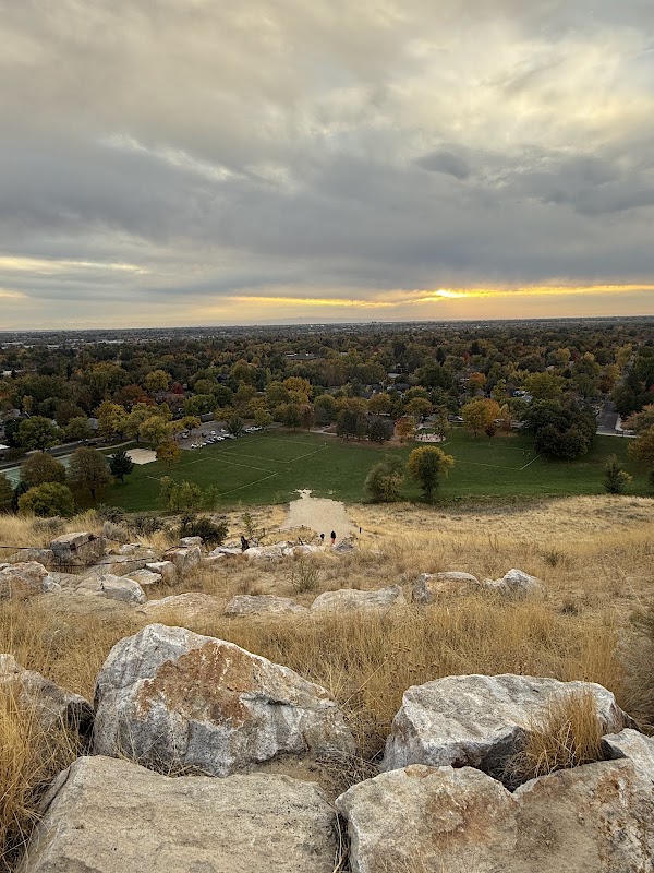
The Ridge to Rivers trail system in Boise Foothills unfurls like a lively grid of adventure just a short drive from Nampa, Idaho. With over 190 miles of interconnected trails, this network invites hikers to walk paths where the terrain converses boldly — rocky ridges press upward while forest stretches out with whispering pines and sagebrush. Approaching on foot, you’ll engage with these foothills that are fiercely themselves: slopes rising and dipping in rhythms shaped by wind and time.
Start your hike at common trailheads like the Military Reserve or Hulls Gulch to enjoy a tangible connection to the landscape’s layers. Average trail distances vary from quick 3-mile loops to epic 10+ mile routes covering ridgelines and valleys. Expect elevation gains ranging between 500 to 1,200 feet depending on your route, enough to coax your lungs into deeper breaths but not overwhelm.
Rock and dirt intermingle on dry trails, a mix of packed earth, loose stones, and occasional wooden boardwalks paralleling creek crossings where water dares you onward. Trees lean over narrow paths, offering shade and the rustle of life—mountain chickadees flitting alongside, squirrels alert to your presence.
For those planning, hydration is key—several trailheads lack potable water sources, so bring at least two liters. Sturdy footwear with good grip will handle the varied soil and occasional loose rock. Early morning or late afternoon hikes offer cooler temps and softer light, a practical window to enjoy vistas without midday sun sapping energy.
Respect the land’s pace. The Ridge to Rivers trails are not a challenge to conquer but a force engaging your senses and stamina. Whether you’re a casual stroller or a determined trail runner, the foothills’ trails unfold with a steady pulse, a mix of open ridges that release panoramic views of Boise Valley and shaded forest corridors that hold cool secrets.
Parking is usually ample but can fill quickly on weekends, so plan accordingly. Dogs are welcome but must be leashed. Maps and navigation apps are recommended as trail intersections can be intricate.
In essence, Ridge to Rivers invites its visitors into Boise’s foothills with whatever pace they bring, balancing rugged natural beauty with practical accessibility—an outdoor playground tempered by terrain that commands attention and respect. Prepare well, watch your step, and let the foothills push you into their rhythm.
Nearby Trips
All Adventures
Boat Charters
Water Activities
Adventures near Boise, Idaho
Discover the unique and memorable adventures that make Boise, Idaho special.
Frequently Asked Questions
How do I access the Ridge to Rivers trail system from Nampa?
From Nampa, it’s about a 30-minute drive east on I-84 and local roads to various Boise Foothills trailheads. Military Reserve and Hulls Gulch are popular starting points accessible via Boise city streets.
Are dogs allowed on the Ridge to Rivers trails?
Yes, dogs are welcome but must be kept on leash to protect local wildlife and other hikers.
What level of fitness do I need to hike these trails?
Most trails range from easy to moderate with elevation gains up to 1,200 feet. Casual hikers with reasonable fitness can enjoy the system, while more challenging routes exist for seasoned hikers.
Is there cell phone service along the trails?
Service can be spotty in more remote or steep areas, so download maps in advance and prepare accordingly.
Can I mountain bike on Ridge to Rivers trails?
Several trails are multi-use and open to mountain bikers, but some sections are hiking-only. Check the Ridge to Rivers official map for bike-friendly routes.
What wildlife might I see during my hike?
Expect to encounter mule deer, coyotes, various songbirds, and occasionally raptors working the thermals above ridges.
Recommended Gear
Hydration pack or water bottles
Staying hydrated is vital as water availability on trails is limited.
Hiking boots or trail shoes
Provides support and grip over rocky and uneven surfaces.
Sun protection (hat, sunglasses, sunscreen)
Protects against harsh sun exposure on exposed ridges and open trails.
Layered clothing
Allows adjustment to shifting temperatures and protects against wind and chill.
Local Insights
Hidden Gems
- "The summit of Table Rock offers one of the most rewarding panoramic views, especially near sunset."
- "Hidden pockets of native bitterbrush bloom distinctively in early spring along the lower trails."
Wildlife
- "Watch for raptors like red-tailed hawks gliding overhead on warm afternoons."
- "Mule deer and occasional bobcats use the foothills as part of their natural habitat."
History
"The Boise Foothills have ancient roots tied to indigenous tribes and early settlers. Several trails cross historic mining areas from the late 1800s, remnants of Idaho’s frontier past."