Traverse North Carolina’s Wild Heart: The 1,100-Mile Mountains-to-Sea Trail
Cross more than 1,100 miles from the Outer Banks to the Great Smoky Mountains on North Carolina’s Mountains-to-Sea Trail. Navigate towering peaks, coastal dunes, and farmland, all while experiencing a trail alive with challenges, ferry rides, and breathtaking overlooks. Whether you're aiming for a day trek or the entire journey, this route offers adventure grounded in preparation and discovery.
Choose Footwear for Varied Terrain
Expect rocky mountain paths, sandy coastal stretches, and muddy forest floors. Durable, waterproof boots with solid ankle support will serve you best across these changing conditions.
Hydrate Continuously
Sections in the lowlands can be hot and humid, increasing dehydration risk. Carry ample water and use refill points wisely; some stretches have limited fresh water access.
Check Weather and Trail Conditions
Mountain weather changes fast—storms appear without warning and might make trails slick; coastal sections can flood during storms. Always have updated forecasts before setting out.
Utilize Ferry and Side Trails
Ferries connect the Outer Banks sections, while side trails offer views without major detours. Plan schedules around ferry times to avoid long waits and optimize your hiking day.
Traverse North Carolina’s Wild Heart: The 1,100-Mile Mountains-to-Sea Trail
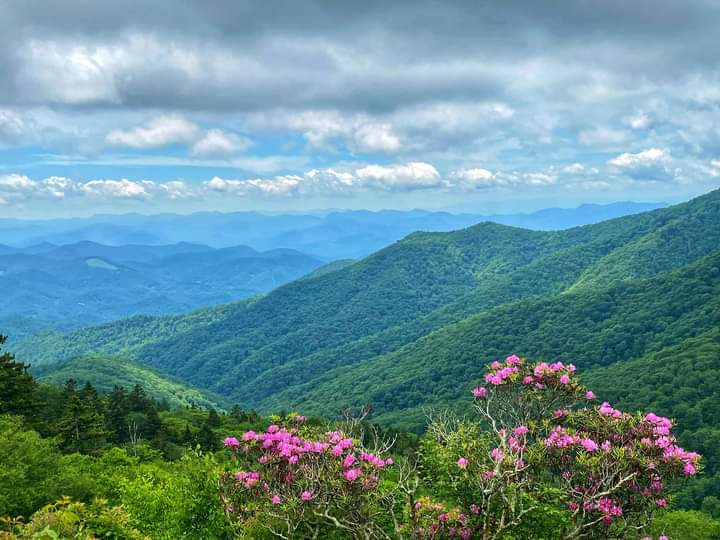
Stretching from the wind-sculpted dunes of Jockey's Ridge on the Outer Banks to the mist-covered peaks of Clingman's Dome in the Great Smoky Mountains, North Carolina’s Mountains-to-Sea Trail challenges and rewards with its rugged passage through forests, farms, and coastal breezes. This 1,100-plus-mile trail dares you to cross the highest point east of the Mississippi—Mount Mitchell—where panoramic views push you to breathe deeper and move onward.
The trail is alive with variety. Ferry rides link you to barrier islands, side paths pull you to cliffs and overlooks, and temporary road segments weave through rural life until volunteers complete the permanent route. It’s a trail relentlessly carving through landscapes fiercely themselves. Whether day-hiking forested sections or stretching weeks to complete longer portions, this journey is shaped by your pace and ambition.
Planning is key: elevation gain fluctuates dramatically, from nearly flat coastal stretches to steep ascents above 6,600 feet at Mount Mitchell. Wear boots that grip wet roots and rocky slabs, pack layers for rapidly shifting mountain weather, and prepare for sections under the southern sun where hydration is your lifeline. Trail markers guide you, but keep a map handy when routes ride beside roads or bicycle paths.
Each segment invites discovery. Historic mining towns offer rest and local flavor. Wildflowers bloom in hidden hollows. Streams and rivers seem to test your resolve with currents urging swift crossings. Overnight shelters stand as waypoints, yet wilderness often demands self-reliance.
From the salty air that pulls at your sleeves on the coast to the dense spruce-fir forests breathing cool, fragrant air in higher elevations, this trail presents an adventure that respects nature as an equal force. Completing all segments grants a place on an exclusive register—a trophy not just of miles traveled but of a journey through a state fiercely diverse and endlessly wild. Step onto the Mountains-to-Sea Trail—where North Carolina reveals itself one worn bootstep at a time.
Nearby Trips
All Adventures
Boat Charters
Water Activities
Adventures near Asheville, North Carolina
Discover the unique and memorable adventures that make Asheville, North Carolina special.
Frequently Asked Questions
Is the Mountains-to-Sea Trail suitable for beginners?
While some lowland and coastal sections are beginner-friendly, the trail overall includes steep elevation changes and rugged terrain that require moderate to advanced hiking experience and preparation.
Where can I resupply food and water on the trail?
Towns like Asheville, Black Mountain, and New Bern serve as major resupply points. Water sources exist along the way but often need treatment, so plan to refill and filter when possible.
Are pets allowed on the trail?
Pets are generally allowed but must be leashed. Some sensitive environmental areas may have restrictions, so check local regulations before setting out with your companion.
Can I complete the entire trail in one trip?
Most hikers break the trail into sections due to its length and diversity; completing the entire trail requires several weeks and extensive planning for logistics, weather, and physical endurance.
What safety precautions should I take?
Carry a first aid kit, monitor weather closely, stay hydrated, use maps or GPS devices, and inform someone of your itinerary. Mountain sections can be remote with limited cell service.
Are there guided tours or group hikes available?
Some local clubs and outfitters offer guided day hikes or section hikes along parts of the trail, but a full guided thru-hike is uncommon. Volunteering with trail organizations is also a way to experience the route.
Recommended Gear
Waterproof Hiking Boots
Stay stable and dry across rocky, wet, and muddy trail conditions from mountains to coast.
Layered Clothing System
Manage temperature swings especially at high elevations and during autumn mornings and nights.
Hydration System with Filter
Continuous hydration is critical, and water sources vary in quality; filtering ensures safe drinking water.
Compact Emergency Shelter
For winter hikers or sudden storms in remote sections, a lightweight shelter can be lifesaving.
Local Insights
Hidden Gems
- "The Crabtree Falls overlook offers a near-secret waterfall view rarely crowded even during peak seasons."
- "The serene lands around Linville Gorge provide quiet campsites away from the main trail flow."
Wildlife
- "Black bears are common in mountainous segments; proper food storage and respect for wildlife are crucial."
- "Coastal segments support migratory shorebirds and occasional dolphin sightings near ferry crossings."
History
"Parts of the trail cross historic Cherokee lands and old mining communities, weaving a narrative that connects natural and cultural heritage."