Best Backpacking Routes in the Great Smoky Mountains National Park: Adventure Awaits Near Asheville
The Great Smoky Mountains National Park offers some of the Southeast's premier backpacking routes just a short drive from Asheville. Experience challenging climbs, lush forests, and sweeping views while equipped with practical advice to make your adventure safe and rewarding.
Stay Hydrated and Treat Water
Carry at least 2 liters of water and bring a filter or purification tablets. Streams may look clear but carry natural microbes that won’t respect your thirst.
Wear Sturdy Hiking Boots
Trail surfaces vary from slick rocks to exposed roots. Solid ankle support and good tread decrease injury risk on uneven terrain.
Start Early to Avoid Afternoon Storms
Summer weather often brings rapid afternoon thunderstorms. Getting on the trail early maximizes clear, safe hiking windows.
Layer Clothing for Variable Weather
Mountain weather shifts fast—packs should include moisture-wicking layers and a water-resistant shell to keep you ready for rain or cooling temperatures.
Best Backpacking Routes in the Great Smoky Mountains National Park: Adventure Awaits Near Asheville
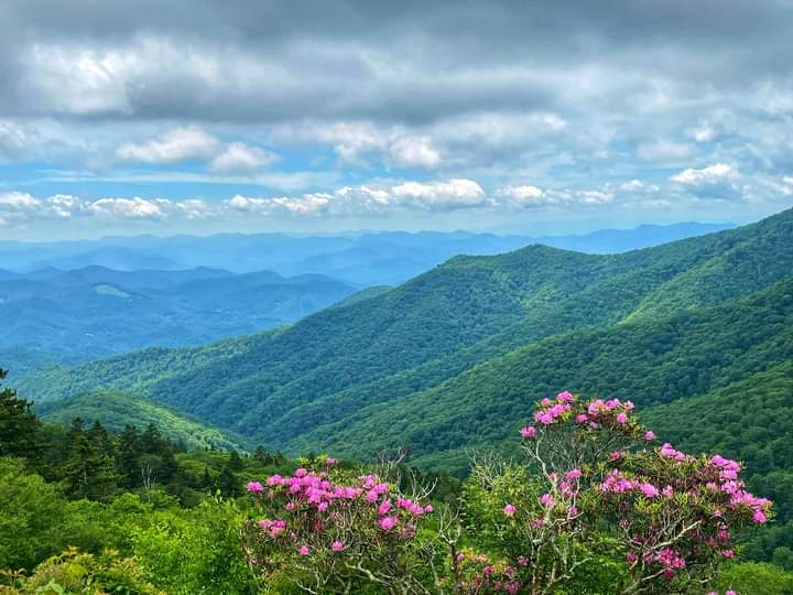
The Great Smoky Mountains National Park stretches across the Tennessee-North Carolina border, offering backpackers an unfiltered encounter with nature’s raw pulse—just an hour's drive from Asheville. Here, backpacking trails weave through ancient hardwood forests where branches creak in the mountain breeze and streams challenge your resolve with their icy currents.
Appalachian Trail to Charlie’s Bunion (8 miles round-trip, 1,700 ft elevation gain) climbs steadily through rhododendron tunnels before opening onto a rocky outcrop where winter winds test your grip and views unfold over the Blue Ridge. Its constant incline demands stamina but rewards with panoramic vistas that fuel every step. Trail surfaces vary from exposed roots to slick granite slabs—solid hiking boots and trekking poles help steady your pace.
For those seeking longer immersion, the Forney Ridge Trail to Andrews Bald (6.8 miles round-trip, 1,050 ft elevation gain) offers a gentler climb with shaded forest paths that calm and cool. The bald itself presents wide-open meadows where clouds drift low, testing your sensitivity to weather shifts and calling for layered clothing. It’s an ideal route for moderate backpackers who appreciate a balance of challenge and tranquility.
The Deep Creek Loop (7.4 miles, 1,200 ft elevation gain) introduces dynamic terrain—rocky creek crossings daring you to stay dry, and cascading waterfalls that drum a steady rhythm. The trail’s natural orchestra guides your pace, reminding you that the mountains are alive with sound and movement. Suitable for intermediate hikers, this route demands steady footing and a readiness for sudden weather changes.
Preparation is key across all routes: carry at least 2 liters of water, treat natural sources with purification methods, and schedule your hike for early mornings to dodge afternoon thunderstorms common in warmer months. Footwear with solid ankle support and traction is essential; weather can turn sharply, so pack quick-dry layers and a reliable rain shell.
As daylight wanes, the forest seems to breathe around you, shadows lengthening and the scent of earth and pine rising. The Smokies insist on respect—every ridge and river is fiercely itself, offering not just trails but conversations with a landscape that remembers every footfall. Whether you’re pressing for a summit or wandering through quiet meadows, this is a mountain to engage with thoughtfully, equipped and alert. Your backpack carries gear; your mind, readiness.
Nearby Trips
All Adventures
Boat Charters
Water Activities
Adventures near Asheville, North Carolina
Discover the unique and memorable adventures that make Asheville, North Carolina special.
Frequently Asked Questions
Are permits required for backpacking in the Great Smoky Mountains?
Yes, overnight backpacking requires a permit which can be obtained from park visitor centers or online. Permits regulate campsite use to protect the environment and improve visitor safety.
What wildlife might I encounter on these backpacking routes?
Black bears are common but generally avoid humans; sightings are often from a distance. You may also see white-tailed deer, wild turkeys, and seasonal songbirds.
Are the trails dog-friendly?
Pets are not allowed on most backcountry trails in the park to protect wildlife and fragile habitats.
What safety precautions should I take at stream crossings?
Check water depth and current strength before crossing. Use trekking poles for balance and cross at shallow, wider spots when possible.
Where can I find lesser-known viewpoints along these routes?
Along the Forney Ridge Trail, a short spur leads to Gregory Bald, offering quieter but equally stunning views compared to Andrews Bald.
Is there cell phone coverage on these trails?
Coverage is spotty to nonexistent in backcountry areas—plan accordingly and carry a map and compass for navigation.
Recommended Gear
Hiking Boots
Provide ankle support and grip needed for rocky, uneven trails.
Water Purification System
Ensures safe hydration from mountain streams.
Layered Clothing
Adapts to rapidly changing mountain weather, including moisture-wicking base layers and waterproof shells.
Trekking Poles
Useful for balance across uneven terrain and reducing impact on knees during descents.
Local Insights
Hidden Gems
- "Gregory Bald for panoramic views without the crowds"
- "Hen Wallow Falls on the Deep Creek Loop offers a quieter waterfall experience"
Wildlife
- "Black bears"
- "Peregrine falcons nesting on cliff faces"
- "Eastern box turtles"
History
"The park’s forests have recovered from early 20th-century logging; many trails follow old logging roads repurposed by early conservation efforts."