
Mýrdalsjökull Glacier Adventures
Mýrdalsjökull is one of Iceland's most renowned glaciers, famed for its stunning ice cap that covers the active volcano Katla. It offers extraordinary ice hiking and adventure opportunities amidst Icelandic natural beauty.
About Mýrdalsjökull Glacier
Mýrdalsjökull Glacier, located in the South of Iceland, is the fourth largest glacier in the country, covering approximately 232 square miles (600 km²). The glacier's most notable feature is its thick ice cap that conceals the active volcano Katla, which has erupted frequently over the years, influencing the surrounding landscape. The area offers diverse recreational activities such as glacier hiking, ice climbing, and exploring ice caves during winter months. The diverse habitat around the glacier supports a variety of flora and fauna, and its dramatic scenery attracts photographers and adventure seekers from around the world. Visitors can enjoy awe-inspiring views of the surrounding rugged mountains and nearby black sand beaches, adding to the majestic character of the glacier.
Highlights
The stunning views from the glacier's edge overlooking Iceland's southern coast.
Challenging ice climbing on the glacier's dramatic frozen ridges.
The active Katla volcano beneath the glacier, a geological wonder.
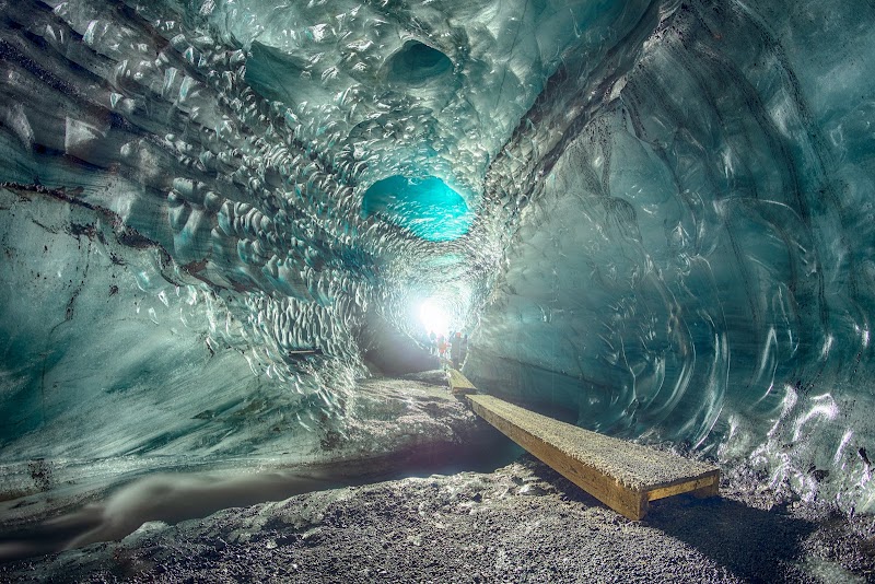
Exploring the mesmerizing ice caves formed during winter.
Notable Natural Features
Katla Volcano
An active subglacial volcano located beneath the ice cap, known for its powerful eruptions.
Ice Caves
Accessible during winter months, these caves offer stunning natural ice formations.
Black Sand Beaches
Located nearby, providing a stark contrast against the white, icy landscape of the glacier.