THE ADVENTURE COLLECTIVE® · Independent discovery and booking for outdoor travel

A 30-minute scenic flight from Waiheke Aerodrome puts vineyards, beaches, and Rangitoto’s volcanic cone into sharp relief. Fast, accessible, and rich with panorama—this air tour is the clearest way to read Waiheke’s landscape before you step ashore.
A 30-minute scenic flight from Waiheke Aerodrome puts vineyards, beaches, and Rangitoto’s volcanic cone into sharp relief. Fast, accessible, and rich with panorama—this air tour is the clearest way to read Waiheke’s landscape before you step ashore.
We lift off from Waiheke Aerodrome and the island rearranges itself beneath you: a patchwork of vineyards, a shoreline that alternates between wind-swept cliffs and broad, pale beaches, and the blunt cone of Rangitoto rising like a dark, young island off the northeastern horizon. In thirty minutes the pilot eases the Cessna into slow, deliberate arcs so every passenger gets a clear view; the wind becomes a companion, the ocean a mirror—at once intimate and immense.
Verified experiences and guided adventures in the surrounding area.
Operated by Auckland Seaplanes · Waiheke Island, Auckland
We lift off from Waiheke Aerodrome and the island rearranges itself beneath you: a patchwork of vineyards, a shoreline that alternates between wind-swept cliffs and broad, pale beaches, and the blunt cone of Rangitoto rising like a dark, young island off the northeastern horizon. In thirty minutes the pilot eases the Cessna into slow, deliberate arcs so every passenger gets a clear view; the wind becomes a companion, the ocean a mirror—at once intimate and immense.
Waiheke’s modern identity is stitched to two things you’ll see clearly from the air: wine and coastline. Vineyards planted on terraces follow ridgelines that were carved by ice-age seas and more recent volcanic events. Rangitoto, the youngest volcano in the Auckland volcanic field, erupted around 600 years ago and still reads as fresh basalt against the harbor’s blue. Māori have navigated these waters for centuries; you’ll spot pa sites and coastal groves that map old travel routes between islands.
The island’s vineyards—planted since the late 19th century and reborn after the 1980s boutique wine boom—look different from above: small parcels with neat rows hugging gullies. Beaches such as Oneroa and Onetangi appear as pale slashes, and sheltered bays tuck yachts like coins in a velvet pocket. Marine life can interrupt the view: dolphins often trail the ferry routes, and shearwaters ride the thermals.
Practicalities matter. The flight departs from Waiheke Airport (171 Carsons Road) after arriving by Fullers360 ferry; the operator provides curbside pickup at the ferry terminal if requested. The entire loop is 30 minutes—long enough for a comprehensive overview but short enough that motion-sensitive travelers should plan ahead. Flights can be cancelled for weather or low passenger numbers; operators request passenger weights for balance and infants must sit on laps.
For travelers, timing is everything. Morning flights offer softer light over vineyards; late afternoon gives deeper contrast and a warmer palette on the coastline. Bring a windbreaker and secure your camera—the plane is small and breezes sneak through when doors open on the ground. Respect safety briefings: this is an easy, accessible aerial introduction to Waiheke, but it still moves you through a working harbor and volcanic landscape.
In short: this is an efficient, sensory-rich way to read Waiheke’s geography and culture in one sweep. It’s ideal for first-time visitors who want context before exploring on foot or by car, and for photographers who want a fresh vantage on vineyards, volcanic forms, and the start of the Hauraki Gulf’s edge.
easy.
30 minutes.
No special fitness required; suitable for most travelers though those with serious spinal or heart conditions should avoid
The tour is a fixed 30-minute scenic flight departing from Waiheke Aerodrome.
After arriving by Fullers360 ferry, head to Waiheke Airport (171 Carsons Road); pickup from the ferry terminal can be arranged if requested.
Yes—infants must sit on an adult’s lap; advise the operator at booking.
Yes—operators cancel for bad weather or insufficient passengers; cancel at least 24 hours in advance for a full refund per policy.
No—this tour is not recommended for travelers with spinal injuries or poor cardiovascular health.
Yes—weight is requested during booking so the pilot can safely balance the aircraft.
Rangitoto’s eruption roughly 600 years ago shaped the eastern harbor; Māori and later European settlers used the island’s sheltered bays for travel and farming.
Operators follow weather and safety guidelines to limit noise and disturbance; visitors should avoid low passes and respect marine-life viewing distances.
Auckland Seaplanes operates guided outdoor trips and adventures with an emphasis on safety, stewardship, and memorable experiences.
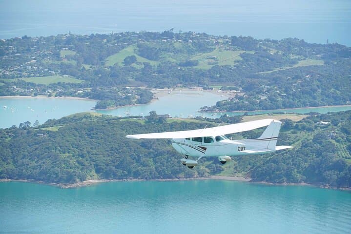
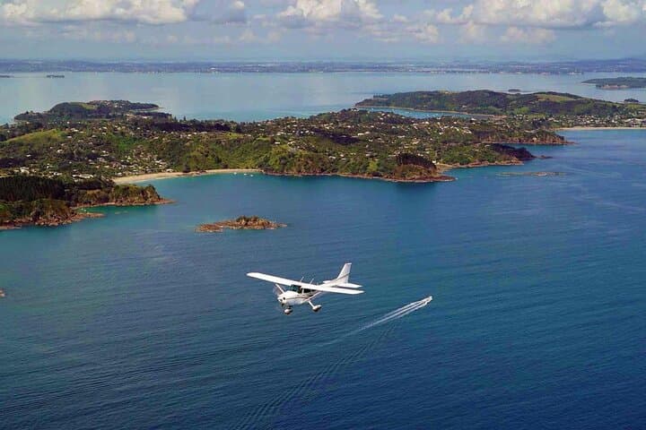
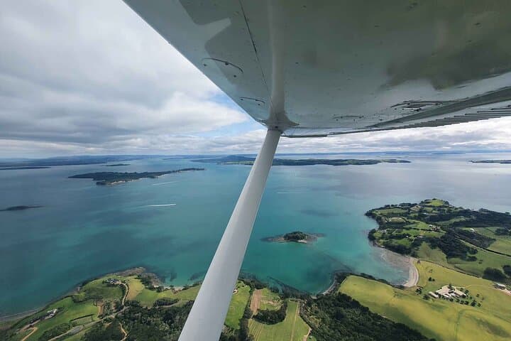
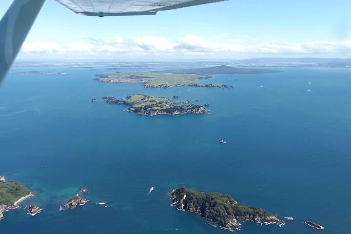
We lift off from Waiheke Aerodrome and the island rearranges itself beneath you: a patchwork of vineyards, a shoreline that alternates between wind-swept cliffs and broad, pale beaches, and the blunt cone of Rangitoto rising like a dark, young island off the northeastern horizon. In thirty minutes the pilot eases the Cessna into slow, deliberate arcs so every passenger gets a clear view; the wind becomes a companion, the ocean a mirror—at once intimate and immense.
We lift off from Waiheke Aerodrome and the island rearranges itself beneath you: a patchwork of vineyards, a shoreline that alternates between wind-swept cliffs and broad, pale beaches, and the blunt cone of Rangitoto rising like a dark, young island off the northeastern horizon. In thirty minutes the pilot eases the Cessna into slow, deliberate arcs so every passenger gets a clear view; the wind becomes a companion, the ocean a mirror—at once intimate and immense.
Waiheke’s modern identity is stitched to two things you’ll see clearly from the air: wine and coastline. Vineyards planted on terraces follow ridgelines that were carved by ice-age seas and more recent volcanic events. Rangitoto, the youngest volcano in the Auckland volcanic field, erupted around 600 years ago and still reads as fresh basalt against the harbor’s blue. Māori have navigated these waters for centuries; you’ll spot pa sites and coastal groves that map old travel routes between islands.
The island’s vineyards—planted since the late 19th century and reborn after the 1980s boutique wine boom—look different from above: small parcels with neat rows hugging gullies. Beaches such as Oneroa and Onetangi appear as pale slashes, and sheltered bays tuck yachts like coins in a velvet pocket. Marine life can interrupt the view: dolphins often trail the ferry routes, and shearwaters ride the thermals.
Practicalities matter. The flight departs from Waiheke Airport (171 Carsons Road) after arriving by Fullers360 ferry; the operator provides curbside pickup at the ferry terminal if requested. The entire loop is 30 minutes—long enough for a comprehensive overview but short enough that motion-sensitive travelers should plan ahead. Flights can be cancelled for weather or low passenger numbers; operators request passenger weights for balance and infants must sit on laps.
For travelers, timing is everything. Morning flights offer softer light over vineyards; late afternoon gives deeper contrast and a warmer palette on the coastline. Bring a windbreaker and secure your camera—the plane is small and breezes sneak through when doors open on the ground. Respect safety briefings: this is an easy, accessible aerial introduction to Waiheke, but it still moves you through a working harbor and volcanic landscape.
In short: this is an efficient, sensory-rich way to read Waiheke’s geography and culture in one sweep. It’s ideal for first-time visitors who want context before exploring on foot or by car, and for photographers who want a fresh vantage on vineyards, volcanic forms, and the start of the Hauraki Gulf’s edge.