THE ADVENTURE COLLECTIVE® · Independent discovery and booking for outdoor travel

A high-altitude day hike from Cusco to Vinicunca (Rainbow Mountain) and the adjacent Red Valley, combining mineral-striped slopes, Andean views and Quechua cultural touches. Expect a long day with significant altitude and variable trail surfaces.
A high-altitude day hike from Cusco to Vinicunca (Rainbow Mountain) and the adjacent Red Valley, combining mineral-striped slopes, Andean views and Quechua cultural touches. Expect a long day with significant altitude and variable trail surfaces.
A pale, high wind meets you before the colors do: thin air that pricks lungs and flutters a borrowed jacket as you step onto the trailhead at 4,630 m. The path climbs through ochre slopes and sheep-scattered meadows, and the ridgelines open like pages—first the broad sweep of Ausangate’s snow shoulders, then the banded face of Vinicunca, stripes of iron, copper and carbonate standing vertical against the sky.
Verified experiences and guided adventures in the surrounding area.
Operated by Apu Ausangate Trek · Cusco, Cusco
A pale, high wind meets you before the colors do: thin air that pricks lungs and flutters a borrowed jacket as you step onto the trailhead at 4,630 m. The path climbs through ochre slopes and sheep-scattered meadows, and the ridgelines open like pages—first the broad sweep of Ausangate’s snow shoulders, then the banded face of Vinicunca, stripes of iron, copper and carbonate standing vertical against the sky.
Geologically the “rainbow” is straightforward: layered mineral sediments uplifted and exposed, stained by iron oxides, chlorites and other elements over millennia. Culturally the range sits on Quechua lands carved by pastoral life; guides here often speak Quechua and point out ancestral stone corrals and grazing alpacas. The modern surge of visitors is recent—Vinicunca rose to fame in the last decade—yet the surrounding valleys still hold quiet towns where breakfast is local bread and coca tea.
In practice this is a long day: a 3-hour drive from Cusco, a 1.5–2 hour ascent, an hour at the viewpoint and a fast return. Expect rocky, sometimes muddy trails and sharp altitude change—pace matters more than speed. Bring layered clothing for sun and wind, a hydration system and sunscreen; sit with your guide if you feel lightheaded and use coca leaves or tea as locals do. Start early to avoid afternoon clouds and aim for the dry season (May–Sept) for the clearest views. Walk deliberately, leave no trace, and allow extra time for photography and short cultural exchanges in the highland hamlets en route.
moderate.
15–16 hours (door-to-door).
Able to hike 2–3 hours roundtrip on uneven ground at high altitude; good cardiovascular fitness recommended and prior acclimatization helpful.
Physically it’s moderate—short but steep sections over uneven ground; the real challenge is altitude so acclimatization and a steady pace are key.
There is an entrance fee for Vinicunca; most operators include it in the tour price and handle payment at the trailhead.
Symptoms range from headache and nausea to dizziness; descend, rest, hydrate, and seek medic support if symptoms worsen—guides carry basic first-aid and oxygen on many tours.
Legally you can access the trail independently, but most visitors use a guided tour for logistics, transport, and local knowledge—also helpful for language and safety.
The slopes sit within Quechua-speaking highlands; pastoral economies and Inca-era routes have shaped the region for centuries.
Heavy visitation causes trail erosion and waste issues; stick to designated paths, pack out trash, and choose operators supporting local conservation efforts.
Apu Ausangate Trek operates guided outdoor trips and adventures with an emphasis on safety, stewardship, and memorable experiences.


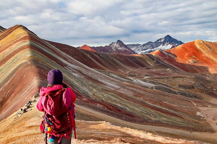

A pale, high wind meets you before the colors do: thin air that pricks lungs and flutters a borrowed jacket as you step onto the trailhead at 4,630 m. The path climbs through ochre slopes and sheep-scattered meadows, and the ridgelines open like pages—first the broad sweep of Ausangate’s snow shoulders, then the banded face of Vinicunca, stripes of iron, copper and carbonate standing vertical against the sky.
A pale, high wind meets you before the colors do: thin air that pricks lungs and flutters a borrowed jacket as you step onto the trailhead at 4,630 m. The path climbs through ochre slopes and sheep-scattered meadows, and the ridgelines open like pages—first the broad sweep of Ausangate’s snow shoulders, then the banded face of Vinicunca, stripes of iron, copper and carbonate standing vertical against the sky.
Geologically the “rainbow” is straightforward: layered mineral sediments uplifted and exposed, stained by iron oxides, chlorites and other elements over millennia. Culturally the range sits on Quechua lands carved by pastoral life; guides here often speak Quechua and point out ancestral stone corrals and grazing alpacas. The modern surge of visitors is recent—Vinicunca rose to fame in the last decade—yet the surrounding valleys still hold quiet towns where breakfast is local bread and coca tea.
In practice this is a long day: a 3-hour drive from Cusco, a 1.5–2 hour ascent, an hour at the viewpoint and a fast return. Expect rocky, sometimes muddy trails and sharp altitude change—pace matters more than speed. Bring layered clothing for sun and wind, a hydration system and sunscreen; sit with your guide if you feel lightheaded and use coca leaves or tea as locals do. Start early to avoid afternoon clouds and aim for the dry season (May–Sept) for the clearest views. Walk deliberately, leave no trace, and allow extra time for photography and short cultural exchanges in the highland hamlets en route.