THE ADVENTURE COLLECTIVE® · Independent discovery and booking for outdoor travel

Drive the Pacific coastline from Los Angeles to Tijuana for a one-day photoshoot that pairs dramatic border imagery with Baja surf-town energy. Expect coastal cliffs, a border wall meeting the sea, and colorful Rosarito beaches ideal for golden-hour shots.
Drive the Pacific coastline from Los Angeles to Tijuana for a one-day photoshoot that pairs dramatic border imagery with Baja surf-town energy. Expect coastal cliffs, a border wall meeting the sea, and colorful Rosarito beaches ideal for golden-hour shots.
The day opens with a coastal highway and an ocean that seems to pull the car along—windows down, salt air pushing stories through the cabin. By late morning the border appears not as a line on a map but as a meeting of textures: rusted steel rising out of surf, spray carving letters into rock, fishermen hauling nets where currents remind you who’s really in charge.
Verified experiences and guided adventures in the surrounding area.
The day opens with a coastal highway and an ocean that seems to pull the car along—windows down, salt air pushing stories through the cabin. By late morning the border appears not as a line on a map but as a meeting of textures: rusted steel rising out of surf, spray carving letters into rock, fishermen hauling nets where currents remind you who’s really in charge.
This route stitches together California’s beach towns with Baja California’s coastal culture. Geologically the coastline is a study in uplifted cliffs and sandy spits, where cliff-side vistas on the Scenic Toll Road (Carretera 1D) give way to wide, wind-swept beaches at Rosarito. Historically the border area has been shaped by migration, trade and the maritime industries of both nations; Playas de Tijuana’s shoreline hosts the unusual sight of a border wall meeting the ocean, a stark human line against a vast Pacific backdrop.
Culturally the day balances urban San Diego neighborhoods and Old Town with Baja’s vibrant street food, music and beach recreation in Rosarito—tacos, seafood, horseback rides and ATV runs all coexist along one shoreline.
Practical guidance: bring a valid passport, a charged camera with extra memory, and expect a long day (12–15 hours) largely driven by road with multiple short shoots and walks. Border wait times vary—plan buffer time and avoid peak crossing hours. Sun protection and comfortable shoes matter; some ideal photos require walking on uneven sand or concrete. Respect local signage and private property, and allow time for a relaxed late-afternoon shoot in Rosarito when light softens and colors warm.
moderate.
12–15 hours.
Suitable for most fitness levels—largely vehicle-based with short walks on sand, stairs, or uneven surfaces
Yes; a valid passport is required for entry into Mexico and for return to the United States.
Public beach areas like Playas de Tijuana and Rosarito are commonly photographed; follow your guide’s directions, avoid restricted zones, and stay aware of surroundings.
The full loop is a long day—expect 12–15 hours depending on traffic and border wait times; the itinerary includes stops in San Diego, Tijuana and Rosarito.
Lunch is included per the itinerary, but plan for small purchases or snacks at local vendors during extra stops.
This stretch of coast reflects long histories of maritime trade and cross-border communities; Playas de Tijuana and nearby settlements grew from fishing villages into bustling seaside towns tied to both sides of the border.
Coastal erosion and marine debris are ongoing concerns; respect posted signs, avoid disturbing nesting birds, and dispose of trash properly to protect shorelines.
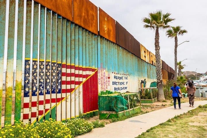
The day opens with a coastal highway and an ocean that seems to pull the car along—windows down, salt air pushing stories through the cabin. By late morning the border appears not as a line on a map but as a meeting of textures: rusted steel rising out of surf, spray carving letters into rock, fishermen hauling nets where currents remind you who’s really in charge.
The day opens with a coastal highway and an ocean that seems to pull the car along—windows down, salt air pushing stories through the cabin. By late morning the border appears not as a line on a map but as a meeting of textures: rusted steel rising out of surf, spray carving letters into rock, fishermen hauling nets where currents remind you who’s really in charge.
This route stitches together California’s beach towns with Baja California’s coastal culture. Geologically the coastline is a study in uplifted cliffs and sandy spits, where cliff-side vistas on the Scenic Toll Road (Carretera 1D) give way to wide, wind-swept beaches at Rosarito. Historically the border area has been shaped by migration, trade and the maritime industries of both nations; Playas de Tijuana’s shoreline hosts the unusual sight of a border wall meeting the ocean, a stark human line against a vast Pacific backdrop.
Culturally the day balances urban San Diego neighborhoods and Old Town with Baja’s vibrant street food, music and beach recreation in Rosarito—tacos, seafood, horseback rides and ATV runs all coexist along one shoreline.
Practical guidance: bring a valid passport, a charged camera with extra memory, and expect a long day (12–15 hours) largely driven by road with multiple short shoots and walks. Border wait times vary—plan buffer time and avoid peak crossing hours. Sun protection and comfortable shoes matter; some ideal photos require walking on uneven sand or concrete. Respect local signage and private property, and allow time for a relaxed late-afternoon shoot in Rosarito when light softens and colors warm.