THE ADVENTURE COLLECTIVE® · Independent discovery and booking for outdoor travel

Two days of steady climbing from Imlil to Mount Toubkal’s 4,167 m summit, returning to Marrakech. Expect rocky trails, early starts, a mountain refuge overnight, and sweeping High Atlas views.
Two days of steady climbing from Imlil to Mount Toubkal’s 4,167 m summit, returning to Marrakech. Expect rocky trails, early starts, a mountain refuge overnight, and sweeping High Atlas views.
Morning in Marrakech smells of coffee and diesel; within an hour the city gives way to olive groves and the road climbs into the High Atlas. By Imlil the air is cooler, stone houses crouch on terraces, and mule trains pick their way up trails that have carried people and goods for centuries. The refuge at 3,207 m perches like a weathered watchtower below the pale ridge of Toubkal, Morocco's highest point at 4,167 m.
Verified experiences and guided adventures in the surrounding area.
Operated by Smart Morocco Tours Excursions · Imlil, Marrakesh-Safi
Morning in Marrakech smells of coffee and diesel; within an hour the city gives way to olive groves and the road climbs into the High Atlas. By Imlil the air is cooler, stone houses crouch on terraces, and mule trains pick their way up trails that have carried people and goods for centuries. The refuge at 3,207 m perches like a weathered watchtower below the pale ridge of Toubkal, Morocco's highest point at 4,167 m.
Geology here is blunt and ancient granite—jagged ridgelines carved by glacial action and winter freezes. The area is culturally Berber: small villages, terraces, and the Sidi Chamharouch shrine punctuate the trail. Guides and muleteers remain the human backbone of ascents, moving at a steady, practical pace.
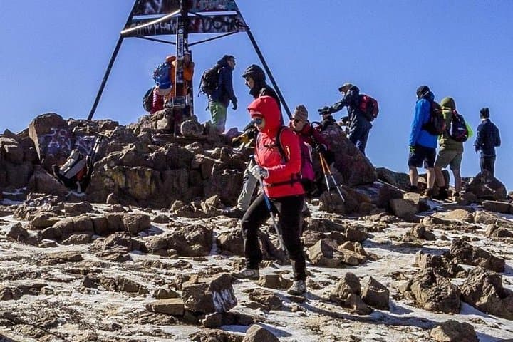
Expect two full days of hiking: day one climbs from Imlil (≈1,740 m) to the refuge—about 5–6 hours and 1,400–1,500 m of elevation gain on rocky switchbacks. Day two starts pre-dawn for the 900–1,000 m push to the summit across scree and short steep sections, then a long descent back to Imlil and transfer to Marrakech.
Practical tips: acclimatize in Marrakech/Imlil if possible, carry 2–3 L of water, use sturdy boots and trekking poles for scree, and pack an early-start headlamp. Weather can flip quickly—sunny valleys can still hold wind and snow near the summit outside summer months. Guides handle logistics and meals; bring personal layers, snacks, and small bills for tips. The route rewards persistence with vast High Atlas panoramas and close-up views of Berber life, making the effort feel earned.
challenging.
2 days.
Good aerobic fitness with experience on sustained uphill hikes; comfortable with long days and altitude exposure.
It’s a challenging but non-technical trek; expect sustained uphill hiking, 5–6 hours day one and an early summit push day two with steep sections and scree.
No technical gear is required in summer; in late fall to spring, crampons or an ice axe may be needed if snow and ice are present and your guide will advise.
Fit beginners with prior long-day hiking experience can succeed with a guide, but you should be prepared for altitude, long days, and uneven terrain.
Typical inclusions are transfers from Marrakech, full board on the trek, accommodation at the refuge, a local guide, and mule support as listed by the operator.
The High Atlas has long been home to Amazigh (Berber) communities; mule tracks and terraced fields trace centuries of mountain life and trade routes.
Sticking to established trails, packing out waste, and following guide instructions helps protect fragile mountain soils and water sources; the region has growing ecotourism efforts to support local communities.
Smart Morocco Tours Excursions operates guided outdoor trips and adventures with an emphasis on safety, stewardship, and memorable experiences.
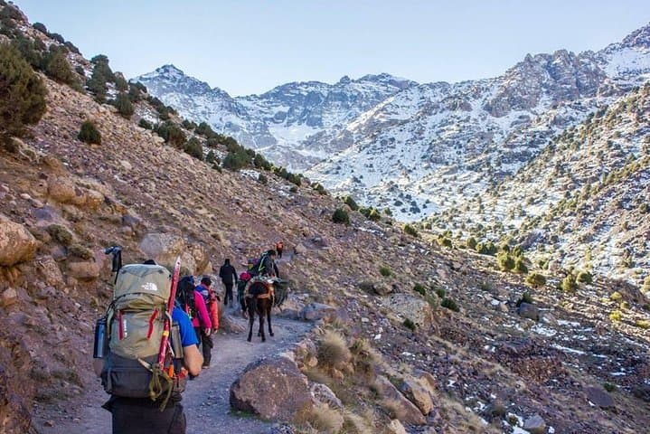


Morning in Marrakech smells of coffee and diesel; within an hour the city gives way to olive groves and the road climbs into the High Atlas. By Imlil the air is cooler, stone houses crouch on terraces, and mule trains pick their way up trails that have carried people and goods for centuries. The refuge at 3,207 m perches like a weathered watchtower below the pale ridge of Toubkal, Morocco's highest point at 4,167 m.
Morning in Marrakech smells of coffee and diesel; within an hour the city gives way to olive groves and the road climbs into the High Atlas. By Imlil the air is cooler, stone houses crouch on terraces, and mule trains pick their way up trails that have carried people and goods for centuries. The refuge at 3,207 m perches like a weathered watchtower below the pale ridge of Toubkal, Morocco's highest point at 4,167 m.
Geology here is blunt and ancient granite—jagged ridgelines carved by glacial action and winter freezes. The area is culturally Berber: small villages, terraces, and the Sidi Chamharouch shrine punctuate the trail. Guides and muleteers remain the human backbone of ascents, moving at a steady, practical pace.
Expect two full days of hiking: day one climbs from Imlil (≈1,740 m) to the refuge—about 5–6 hours and 1,400–1,500 m of elevation gain on rocky switchbacks. Day two starts pre-dawn for the 900–1,000 m push to the summit across scree and short steep sections, then a long descent back to Imlil and transfer to Marrakech.
Practical tips: acclimatize in Marrakech/Imlil if possible, carry 2–3 L of water, use sturdy boots and trekking poles for scree, and pack an early-start headlamp. Weather can flip quickly—sunny valleys can still hold wind and snow near the summit outside summer months. Guides handle logistics and meals; bring personal layers, snacks, and small bills for tips. The route rewards persistence with vast High Atlas panoramas and close-up views of Berber life, making the effort feel earned.