THE ADVENTURE COLLECTIVE® · Independent discovery and booking for outdoor travel

Take a guided autumn trek to Trolltunga and stand on the dramatic rock shelf above Ringedalsvatnet. This full‑day hike blends glacial geology, Norse heritage and fall color with expert guidance for a safer, richer experience.
Take a guided autumn trek to Trolltunga and stand on the dramatic rock shelf above Ringedalsvatnet. This full‑day hike blends glacial geology, Norse heritage and fall color with expert guidance for a safer, richer experience.
A crisp wind brushes the plate-like rock as you round the last bend: Trolltunga—Troll's Tongue—juts out over Ringedalsvatnet, a flat slab anchored like a daring promise. In autumn the cliffs throw back copper and gold; the lake below goes dark, reflecting a sky that feels both vast and immediate.
Verified experiences and guided adventures in the surrounding area.
A crisp wind brushes the plate-like rock as you round the last bend: Trolltunga—Troll's Tongue—juts out over Ringedalsvatnet, a flat slab anchored like a daring promise. In autumn the cliffs throw back copper and gold; the lake below goes dark, reflecting a sky that feels both vast and immediate.
This ledge is a remnant of glacial sculpting from the last Ice Age; glaciers carved the langstrath of fjords and left the horizontal shelf that became Trolltunga. The region sits inside traditional Vestland farming and fishing country with Norse roots—routes here were long used by locals long before it became an international hiking draw.
Expect a strenuous out-and-back on well-worn mountain trails across open tundra, scree fields and short steep pitches. The trail climbs roughly 800–900 m with exposed sections where weather moves fast; in autumn daylight is reduced and temperatures drop. An experienced guide on an autumn departure reads the land—route choice, microclimate and photo windows—and connects the hike to local history and practical risk management.
Practically: plan for a full day (the operator lists ~10 hours), bring waterproof layers, sturdy boots, a headlamp and extra food. Hydrate before the climb and pace uphill to conserve energy for the exposed ridge and the final approach. Leave no trace, follow your guide’s instructions on photo-time at the edge, and be prepared for quick weather shifts—this is mountain terrain, not a park boardwalk.
challenging.
8–10 hours.
Good aerobic fitness with experience on sustained uphill hikes; able to carry a daypack and manage uneven terrain for long periods.
Typical guided trips run 18–22 km round trip with roughly 800–900 m total elevation gain, taking about 8–10 hours depending on pace and conditions.
Guided groups accept varying abilities, but participants should have prior day-hike experience and decent fitness; unstable footing and long duration make it challenging for true novices.
Guides monitor conditions; tours may be rerouted, delayed or canceled for safety—expect instruction on alternatives or refunds per operator policy.
Yes—there’s usually a queue; follow guide directions for safe photo time and avoid stepping beyond marked safe areas.
Trolltunga formed as glaciers retreated at the end of the last Ice Age; the area has long-standing Norse cultural ties and mountain farming traditions.
Trail erosion and litter are local concerns—stick to marked routes, pack out waste, and travel with licensed guides to minimize impact.
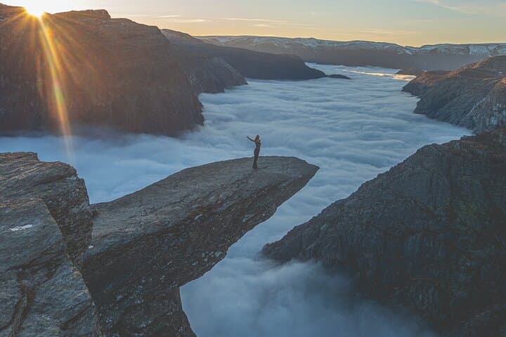
A crisp wind brushes the plate-like rock as you round the last bend: Trolltunga—Troll's Tongue—juts out over Ringedalsvatnet, a flat slab anchored like a daring promise. In autumn the cliffs throw back copper and gold; the lake below goes dark, reflecting a sky that feels both vast and immediate.
A crisp wind brushes the plate-like rock as you round the last bend: Trolltunga—Troll's Tongue—juts out over Ringedalsvatnet, a flat slab anchored like a daring promise. In autumn the cliffs throw back copper and gold; the lake below goes dark, reflecting a sky that feels both vast and immediate.
This ledge is a remnant of glacial sculpting from the last Ice Age; glaciers carved the langstrath of fjords and left the horizontal shelf that became Trolltunga. The region sits inside traditional Vestland farming and fishing country with Norse roots—routes here were long used by locals long before it became an international hiking draw.
Expect a strenuous out-and-back on well-worn mountain trails across open tundra, scree fields and short steep pitches. The trail climbs roughly 800–900 m with exposed sections where weather moves fast; in autumn daylight is reduced and temperatures drop. An experienced guide on an autumn departure reads the land—route choice, microclimate and photo windows—and connects the hike to local history and practical risk management.
Practically: plan for a full day (the operator lists ~10 hours), bring waterproof layers, sturdy boots, a headlamp and extra food. Hydrate before the climb and pace uphill to conserve energy for the exposed ridge and the final approach. Leave no trace, follow your guide’s instructions on photo-time at the edge, and be prepared for quick weather shifts—this is mountain terrain, not a park boardwalk.