THE ADVENTURE COLLECTIVE® · Independent discovery and booking for outdoor travel

A full-day private drive from Tbilisi along the Georgian Military Highway to Gudauri and Stepantsminda, with stops at Jvari, Zhinvali Reservoir, Ananuri, and the 14th-century Gergeti Trinity Church. Expect dramatic mountain panoramas, short hikes, and a mix of medieval and Soviet-era sites.
A full-day private drive from Tbilisi along the Georgian Military Highway to Gudauri and Stepantsminda, with stops at Jvari, Zhinvali Reservoir, Ananuri, and the 14th-century Gergeti Trinity Church. Expect dramatic mountain panoramas, short hikes, and a mix of medieval and Soviet-era sites.
You leave Tbilisi as the city amber light thins and the Georgian Military Highway climbs, windows framing serrated ridgelines and rivers that seem to race you east. The first stop is Jvari, a compact stone church on a windy promontory where Aragvi and Mtkvari (Kura) meet; the view feels like a map drawn in relief.
Verified experiences and guided adventures in the surrounding area.
Operated by Kartutours · Stepantsminda, Mtskheta-Mtianeti
You leave Tbilisi as the city amber light thins and the Georgian Military Highway climbs, windows framing serrated ridgelines and rivers that seem to race you east. The first stop is Jvari, a compact stone church on a windy promontory where Aragvi and Mtkvari (Kura) meet; the view feels like a map drawn in relief.
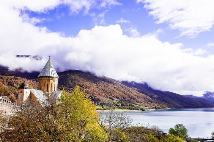
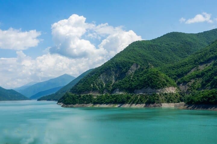
The route threads past Zhinvali Reservoir — a Soviet-era dam holding back a trout-blue basin — then to Ananuri, a castle complex that once housed the eristavis of Aragvi and whose towers still throw long shadows over the Aragvi river valley. Higher up, Gudauri opens as an alpine sweep: broad slopes, ski lifts, and the Soviet-era Friendship Monument, a curved concrete lookout that frames the mountains.
From Gudauri the road continues to Stepantsminda; a short 4x4 climb carries you to Gergeti Trinity Church, a 14th-century stone chapel poised above the valley at high elevation with panoramas of the Greater Caucasus peaks.
Geology here is active uplift — folded metamorphic and sedimentary layers carved by glacial ice — which gives the landscape its abrupt cliffs and long views. Culturally the corridor is a crossroad: medieval fortresses, Orthodox monasteries, and traces of Soviet infrastructure.
Practically: expect a long day (6–9 hours) of driving punctuated by short walks, some uneven surfaces, and a dusty 4x4 approach to Gergeti. Dress in layers for sun and wind, bring water and sun protection, and allow extra time for photos and acclimatizing to higher elevations. Early departures and private transport make the most of the light and reduce time at crowded viewpoints.
moderate.
6–9 hours.
Moderate fitness: comfortable with several short walks, vehicle transfers, and brief stints at altitude.
Yes — the tour is rated easy for fitness; much of it is by vehicle with short walks, but consider mobility limitations for uneven surfaces at viewpoints.
The typical day-trip covers transportation; entrance fees for some sites may be paid on-site — check the operator details at booking.
Expect roughly 120–260 km round trip depending on route and stops, with several hours spent on winding mountain roads; total time is about 6–9 hours.
Altitudes reach around 2,200–3,300 m at Gudauri and the Gergeti overlook; most travelers are fine, but if you have heart or respiratory issues take it easy and inform the operator.
Gergeti Trinity Church dates to the 14th century and became a cultural symbol for local mountain communities; Ananuri served as the seat of the Dukes (eristavis) of Aragvi in medieval times.
High-alpine flora and grazing lands are fragile—stay on existing paths, avoid disturbing pastoral areas, and pack out all trash to minimize your footprint.
Kartutours operates guided outdoor trips and adventures with an emphasis on safety, stewardship, and memorable experiences.
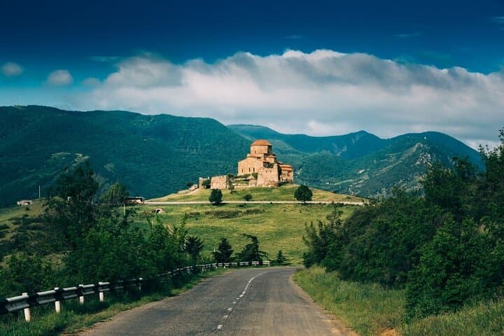
You leave Tbilisi as the city amber light thins and the Georgian Military Highway climbs, windows framing serrated ridgelines and rivers that seem to race you east. The first stop is Jvari, a compact stone church on a windy promontory where Aragvi and Mtkvari (Kura) meet; the view feels like a map drawn in relief.
You leave Tbilisi as the city amber light thins and the Georgian Military Highway climbs, windows framing serrated ridgelines and rivers that seem to race you east. The first stop is Jvari, a compact stone church on a windy promontory where Aragvi and Mtkvari (Kura) meet; the view feels like a map drawn in relief.
The route threads past Zhinvali Reservoir — a Soviet-era dam holding back a trout-blue basin — then to Ananuri, a castle complex that once housed the eristavis of Aragvi and whose towers still throw long shadows over the Aragvi river valley. Higher up, Gudauri opens as an alpine sweep: broad slopes, ski lifts, and the Soviet-era Friendship Monument, a curved concrete lookout that frames the mountains.
From Gudauri the road continues to Stepantsminda; a short 4x4 climb carries you to Gergeti Trinity Church, a 14th-century stone chapel poised above the valley at high elevation with panoramas of the Greater Caucasus peaks.
Geology here is active uplift — folded metamorphic and sedimentary layers carved by glacial ice — which gives the landscape its abrupt cliffs and long views. Culturally the corridor is a crossroad: medieval fortresses, Orthodox monasteries, and traces of Soviet infrastructure.
Practically: expect a long day (6–9 hours) of driving punctuated by short walks, some uneven surfaces, and a dusty 4x4 approach to Gergeti. Dress in layers for sun and wind, bring water and sun protection, and allow extra time for photos and acclimatizing to higher elevations. Early departures and private transport make the most of the light and reduce time at crowded viewpoints.